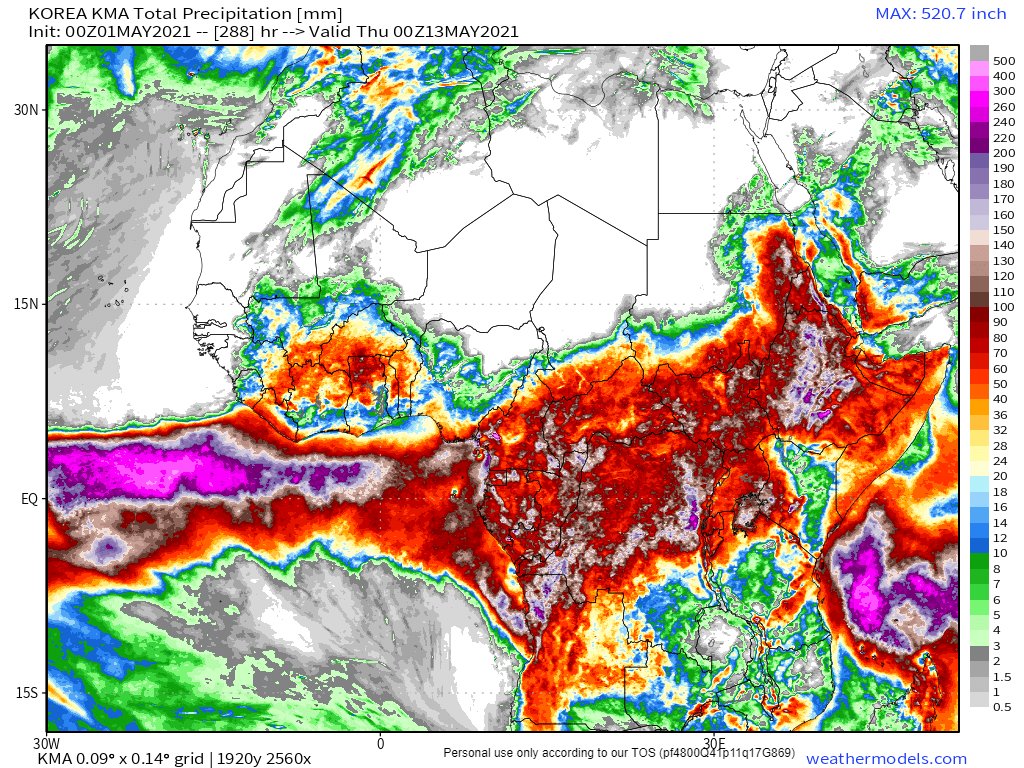
In the world of Africa/Europe/MiddleEast weather today has been quite spectacular, in a new and revealing way. And the star of the show has been the #WestAfricaWaterPlume.

See also.. a thread from this morning....
.. and for a full backgrounder this thread from April 27th.
The plume has now stolen the European stage entering stage left and heading directly towards Moscow. The precipitation animation below is from @Meteoblue. Rain reports are not 100% accurate as they are satellite & not radar driven.

But as for #DesertRain?
There has been a lot.
Another view, same scene from @zoom_earth....

While there is a gap between the African Plume and the mushroom shaped area of storms headed to Moscow, they are moving in lock-step.
This image is from April 19th. The last time this happened. Similarities are obvious, but for the incurious:

In both events we see a percussion cup of storms on the bottom of the storm complex which is being pushed by the plume. In both the pushing is causing precipitation.
Its worth considering the differing scales of these two events.

The first one was pretty disruptive. It's a big part of why its still frosty and 2 degrees in the morning in Western France on the last day of Spring

This event is much much bigger.
And how long will it last?

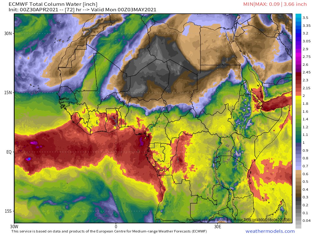
The precipitable water forecasts say we can expect the 1000km wide river of aerial water to keeps flowing till at least Tuesday.

Africa:
Europe:
We now have a new 90 hour ECMWF forecast to midnight Monday - and its still going strong to the end.....
The 10-day 30th April 00hr forecast which is still fresh shows what looks like a firehose of West African wet heading north till Thursday midday. And it doesn't stop then, it just slows down and changes direction.
Ends.... for now.

(continuing story)

• • •

Missing some Tweet in this thread? You can try to force a refresh
 

Keep Current with Alastair Thompson

Alastair Thompson Profile picture

Stay in touch and get notified when new unrolls are available from this author!

Read all threads

This Thread may be Removed Anytime!

PDF

Twitter may remove this content at anytime! Save it as PDF for later use!

Try unrolling a thread yourself!

how to unroll video
  1. Follow @ThreadReaderApp to mention us!

  2. From a Twitter thread mention us with a keyword "unroll"
@threadreaderapp unroll

Practice here first or read more on our help page!

More from @althecat

1 May
There is something glorious about the images that @zoom_earth captures. I especially like the large symmetrical and fairly stationary area of cloud in the North Atlantic in this image.

Today's May 1sy Forecasts for #Ethiopia and #MiddleEast rainfall follow. Image
The main action today was in Europe where the strengthening #WestAfricaMonsoon #WMA has today had a spectacular impact on European Weather.

A detailed thread covering those events can be found here.
Today's North African long range (12 day) rain forecast is taken from the Korean KMA model as it looks to be a lot closer to what we are seeing in the skies today. Image
Read 5 tweets
1 May
I have been tracking the cause of the suddenly extreme weather which is currently underway for past month. The immediate cause is described in this thread

There was a precursor event from April 17-19.

This one is a lot bigger.
And it is far from over. There is at least three more days of incoming #WestAfricaWaterPlume
Read 11 tweets
1 May
The transformation of #WestAfricanPlume's presentation overnight is extraordinary. It's line has moved 1000kms east. It's still running as hot as last night.

A rough estimate of the speed of the cloud movement last night put it an over 220 kms per hour. Image
To comprehend the scale of this thing a series of three animations follows.
Africa and Western Europe...
Read 27 tweets
1 May
This #WestAfricaWaterPlume thingamy is ruining May in Europe. /1 ImageImageImageImage
The wet Atlantic air is set to make its way up into the arctic and settle a low pressure system over Scandinavia.

Together these two factors result in a continuous flow of cold air from the arctic over Scandinavia and North Sea and the UK.
I spent May 2017 in Glasgow and it was glorious. By the end we were getting 29 degree days and everyone was out in the Botanic Gardens with shirts off.

And in Geneva the past two years it’s been a bit thunderstormy, but only in the afternoon. ImageImageImageImage
Read 4 tweets
30 Apr
Today's #ArabianStorms went in a different direction during the day, but ended up in a familiar place in the end.

Today's #MiddleEast and #Ethiopia #HornOfAfrica rain forecasts follow in the thread below.
In the animation above you can see a flow of clouds from Sudan to Oman. This flow actually originates to the South West in the Central African Republic. Here you see the CAR to Khartoum leg of the journey.
Over the day this stream of moisture intensified powering storms in Oman, which then split into two streams, one heading north over Iran and one to the East to India.
Read 13 tweets
30 Apr
The #WestAfricaWaterPlume is rather spectacular in its presentation this morning. Roughly the size of Mexico and growing rapidly - a massive river of moisture which has just reached Italy.
This view shows satellite estimations of rainfall. Again the European @ECMWF weather model appears to have massively underestimated this event. Also on the face of what we can see so far it is turning Eastwards - which is not what many models were predicting.
Here are the current ECMWF predictions as of now, at midnight today, and at midnight Saturday and Sunday.
Read 7 tweets

Did Thread Reader help you today?

Support us! We are indie developers!


This site is made by just two indie developers on a laptop doing marketing, support and development! Read more about the story.

Become a Premium Member ($3/month or $30/year) and get exclusive features!

Become Premium

Too expensive? Make a small donation by buying us coffee ($5) or help with server cost ($10)

Donate via Paypal Become our Patreon

Thank you for your support!

Follow Us on Twitter!