The transformation of #WestAfricanPlume's presentation overnight is extraordinary. It's line has moved 1000kms east. It's still running as hot as last night.
A rough estimate of the speed of the cloud movement last night put it an over 220 kms per hour.
A rough estimate of the speed of the cloud movement last night put it an over 220 kms per hour.
https://twitter.com/althecat/status/1388406421885235201

To comprehend the scale of this thing a series of three animations follows.
Africa and Western Europe...
And a view including Eastern Europe, Russia, central Asia the Middle East and North Africa.
Since the arrival of #WestAfricaWaterPlume over night on Thursday, the weather map of Europe has completely changed, twice.
The weather that was there has been shunted aside, to the North, West and East.
The following 4 tweets show this visually.
The weather that was there has been shunted aside, to the North, West and East.
The following 4 tweets show this visually.
Four images 28/4 to 1/5 at midday follow. In the first below at midday on Wednesday 28th April you see the beginnings of this 2nd major plume event in the bottom left.
Top right you see the aftermath of the last - significantly smaller - plume event which took place 17-19 April
Top right you see the aftermath of the last - significantly smaller - plume event which took place 17-19 April

Midday a day later this animation shows two plumes bottom right. The faster moving one is heading more northwards and this is now over Europe. The other one is headed towards the black sea.
By midday yesterday the plume is already having a massive impact on Europe and Russia where a large storm complex is being pushed northwards rapidly.
[See thread below
[See thread below
https://twitter.com/althecat/status/1388130961737621509?s=20for detail of what happened yesterday.]
This animation shows from 3pm-6pm last night.
9pm to midnight,
Today, 1st May a.k.a #MayDay 6am to 9am
And from 9am to 12pm.
this shows rain across Europe as per @meteoblue as at 12.35pm today. Will be interesting to see how this develops as more and more water is applied to the system.

There are weather warnings across all of Western Europe. meteoalarm.eu

I just checked with friends, its "pissing down" in Geneva and has been for a couple of days. The weather was supposed to be "glorious" as of a week ago.
Climate is what you expect, weather is what you get. So what come's next in this #ClimateChange #EuropeStorms weather event?
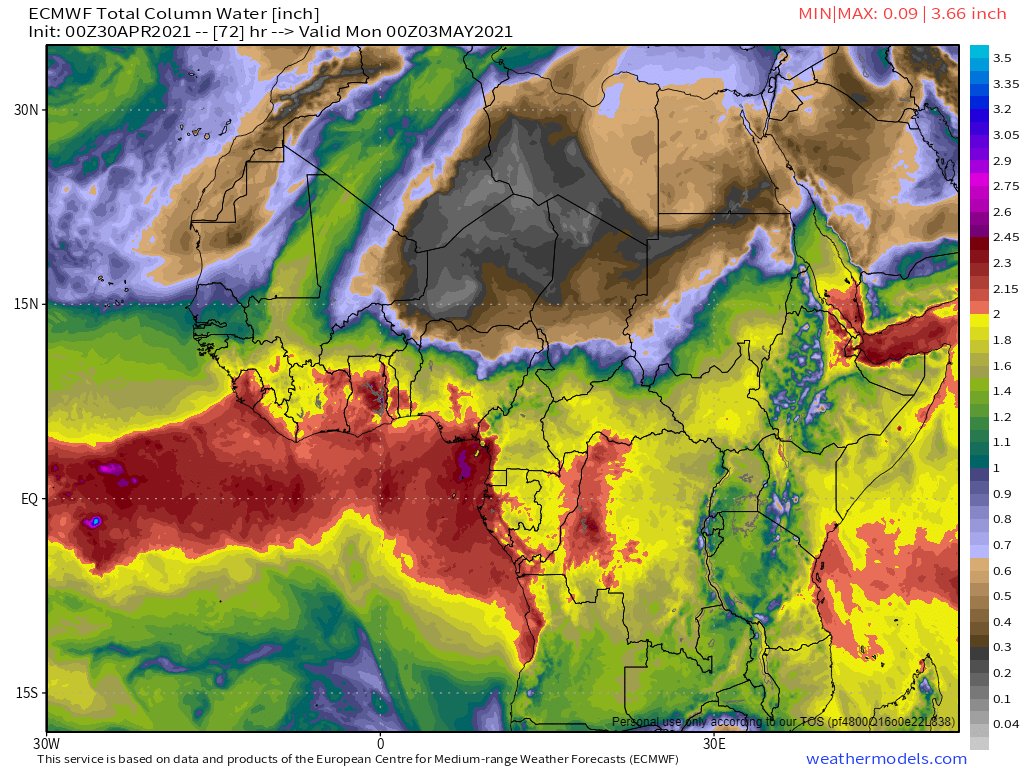
1. The driver of this is the #WestAfricaWaterPlume you can see below in the latest @ECMWF precipitable water 10 day forecast, and Its not over yet.
1. The driver of this is the #WestAfricaWaterPlume you can see below in the latest @ECMWF precipitable water 10 day forecast, and Its not over yet.
2. I ended up doing a second thread with a section looking forward about what is likely to happen in Europe over the coming week here:
https://twitter.com/althecat/status/1388457550472007681?s=20
Continuing today's series of three hourly animations of #WestAfricaWaterPlume here is today at 3pm. It contains some interesting features which are worth zooming in on.
It was not that obvious earlier, but if you look more closely it is clear there are multiple different layers to this weather - also that we have two distinct West African water plumes here, not one. They are on different trajectories and at different altitudes.
The satellite pictures are unclear because what is happening underneath is distinct and separate.
In this closeup you see the plumes as they leave Algeria, heading simultaneously to France & Spain on the left and Italy on the right.
In this closeup you see the plumes as they leave Algeria, heading simultaneously to France & Spain on the left and Italy on the right.
The second huge surprise is that the plume on the right seems to be doing a U-Turn back towards #Africa. There is a possibility this may bring significant rain to #Egypt. Notably this was not in any of the forecasts - but nor was the the two plume complexity.
This is one of two views of what is happening in Northern Europe. At the bottom you see the #Cairo bound plume making its turn. Curling around from the right to top left you see the other plume also making a turn. But what is that in the top left heading NW?
Here's another, clearer view. Some of the weather at the bottom of the stack is making a break for the North Sea, trying to get out of the way.
A close up of what's going on in the North Sea. The breakaway Danish cloud is unlikely to go far as it is running into a strong, cold, northerly wind.
As the sun starts to set the picture has suddenly come a lot clearer as the two plumes have now very significantly diverged. It is also now obvious that the entire system has started to move East.
And that's all for tonight folks.
Thanks for watching those who have been. I think today is a historic day in European Meteorology. It may take a few days or years to understand mind. /ends
Thanks for watching those who have been. I think today is a historic day in European Meteorology. It may take a few days or years to understand mind. /ends

@threadreaderapp unroll
• • •
Missing some Tweet in this thread? You can try to
force a refresh