#AwesomeClimate
This edition of my weekly look at #OurChangingClimate looks at the astonishing atmospheric rivers around the planet and their impacts on us all.
We begin in the Sahara, where an Amazon powered atmospheric river is projecting water all the way to the Levant.
This edition of my weekly look at #OurChangingClimate looks at the astonishing atmospheric rivers around the planet and their impacts on us all.
We begin in the Sahara, where an Amazon powered atmospheric river is projecting water all the way to the Levant.
Each observation consists of at least 48 hours observation of the area in question - abover we see Dec 3-4, below Dec 4-5. [Satellite imagery comes from @zoom_earth]
@zoom_earth Our trip around the globe moves south to take a look at the West African Monsoon 3-5 December. The monsoon is generating an atmospheric river which heads southeast over Southern Africa.
These tropical processes as you see here (Dec 4-5) are highly predictable, varying a little in intensity, but all producing colossal amounts of airborn moisture which then travels colossal distances creating our climate.
Our next picture takes a look at Southern Africa where that atmospheric river is bringing significant rain in a band which is slowly moving north eastwards.
Again above is December 3-5 and below December 4-5. Long range forecasts published last week showed this atmospheric continuing this movement north east and eventually bringing much needed rain to Madagascar.
https://twitter.com/althecat/status/1465367230363938831?s=20
And now we move East and take a look at the mighty Amazon Monsoon, which is strengthening. On the RHS you can see it generating the massive atmospheric river which crosses the Sahara which we saw at the beginning of this thread.
On the LHS you can see the tropical water flow to the West which eventually arrives in South East Asia where it strengthens again over land before continuing its westward journey across the Indian Ocean to bring the water that powers the African monsoon.
Before moving further westward we will head north and look how the tropical Atlantic is projecting moisture directly northwards, where it gets picked up by the jet stream and taken to Europe.
Here we see the Eastward progress of that massive atmospheric river over Iceland. It is right now arriving in West Ireland and will soon bring rain to the UK. When we move further west we will see the influence of the North Pacific water flows on these process.
But first we will look at what happens when water flows from the Amazon, North Atlantic and the West African Monsoon arrive in Europe.
Here we see 24 hours till early this afternoon today. In both the north and south hemisphere, away from the tropics the atmospheric flow is West to East. [See more about this in last week's thread below
https://twitter.com/althecat/status/1465353562679037956?s=20]
Continuing our voyage West here we see the north Pacific. On the extreme RHS we can see North America wich is experiencing a very persistent massive atmospheric river flow of moisture arriving over British Columbia and the North West of the U.S.
Later we will see the origins of the atmospheric river stream on the LHS, which has been produced by a late season super typhoon South of Japan.
But first a closer look at what's happening in the North West of the U.S. where a persistent flow is bringing what I presume is massive amounts of snow to the Rocky Mountains and the Pacific Coastal mountains in British Colombia. Here we begin on December 1st.
December 2nd...
December 3-4
... and December 4-5. As I say this pattern is very persistent. And if you scroll up and have a look at the North Atlantic imagery you can see that a lot of this moisture/energy is crossing Canada and participating in the storm activity over the North Atlantic.
This pattern does appear to be weakening towards the end, which will probably be a bit of a relief to those in its path.
On the other side of the Pacific here we see a key influence on this pattern where Typhoon Nyatoh has been active for the past three days.
On the other side of the Pacific here we see a key influence on this pattern where Typhoon Nyatoh has been active for the past three days.

We have three days of animations of this storm as it illustrates how massive an impact cyclones can have on weather many thousands of KMs away from where they are.
This is because they project so much moisture into the atmosphere, to extraordinary high altitudes. Eventually this water has to return to the earth somewhere, but that can at times be many thousands of kms away.
Also notable is the reversal in direction of the Nyatoh's path.
Also notable is the reversal in direction of the Nyatoh's path.
And then today we see Nyatoh, finally petering out. But its impact will be experienced for many days to come over Canada, and possibly also Europe.
South of West Pacific is one of the biggest monsoons in the world over South East Asia. Like the other monsoons it is predictably and constantly active, migrating south with the change in seasons.
Here we can see it powering another late season cyclone in the top left corner in the Bay of Bengal. But before taking a closer look at India we will move south east to Australia and NZ where the building monsoon is already having some pretty persistent impacts.
The weather in Australia and NZ is impacted by both the West African Monsoon and the SEA Monsoon. NZ more so by the later. Last year these patterns brought considerable flooding to both countries. And more flooding can likely be expected this year based on what we see here.
On the RHS here we can see a cold southerly coming north into the Tasman Sea colliding with a tropical northerly coming in over NZ from the North West.
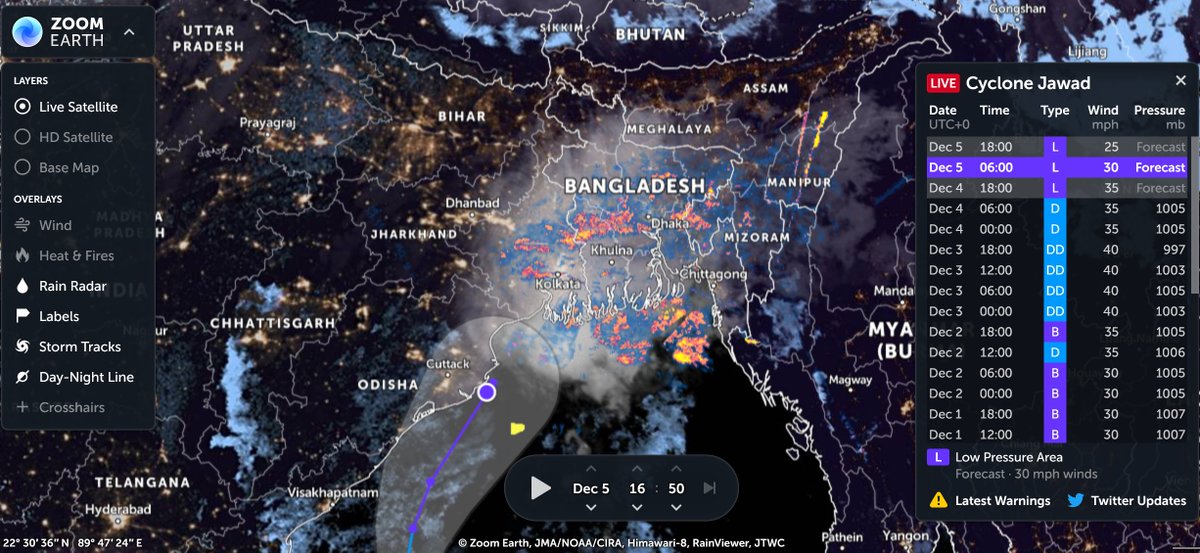
And we end with a closer look at another late season cyclone, Cyclone Jawad which is on a dangerous trajectory into very climate change vulnerable parts of India and Bangladesh. Fortunately it is not particularly powerful in wind terms, albeit carrying massive amounts of water.

Here we see Jawad's development 3-4 December. Towards the end you can see its significant outflows heading north eastwards, this will probably bring rain and snow to China in coming days.
The final animation in this thread shows Cyclone Jawad approaching but the East India coastline, but not making landfall, wile weakening.
And finally an update. While Jawad has weakened so much as a storm that it has no track forecast here, its trajectory remains over water and to the north over Bangladesh you can see its impact in rain terms.
I am planning to continue this weekly series of weather/climate change related threads depending on available time. If you enjoyed this thread please follow.
/ENDS
@Threadreaderapp unroll
/ENDS
@Threadreaderapp unroll
P.S. Last weeks thread is here >>
https://twitter.com/althecat/status/1465325786806824961?s=20
• • •
Missing some Tweet in this thread? You can try to
force a refresh