,
21 tweets,
7 min read
Read on Twitter
Apropos the fortifications of Leith, here's my estimate of the outline of the walls put up by the French who occupied Leith for Mary of Guise from 1548-1560. Nothing remains but some of the modern street alignments still faithful to them
John Street Lane, for instance, curiously almost exactly follows the line of the eastern bastion. 

And the gushet of Baltic Street too


Given 1560 was the age of artillery, I imagine the fortifications were not the sort of tall stone walls of the medieval, but broad earth and rubble breastworks to absorb cannon shot and give an advantageous firing position
They would have been probably topped with a walkway protected by a paling and reinforced with gabions - that is a big wooden fence behind earth-filled wicker cages - and protected from assault by ditches (which also were the source of the spoil for the walls)

These were fortifications thrown up by military engineers in a hurry to protect whatever lay behind. English Civil War fort remains give you an idea of what they may have looked like

There's an article in the journal "Fort" specifically about the Leith fortifications and the NLS hold a copy, so I'll try and get up there to see what that has to offer on the subject.
Thanks to a few people who've pointed me in the direction of some sources! I've rejigged the map with some improved thinking, the main ramparts are in bright red, ditch at the foot of the glacis (slope) in pale red, the palings (fences) in brown and trenches in blue

What I hadn't appreciated was that these fortifications are apparently the oldest instance (by some 10 years) of "modern" (gunpowder age) fortifications in the British isles. They were engineered by an eminant Italian, Piero di Strozzi
di Strozzi was in the pay of the French army, hence him finding his way to Scotland with their troops. He engineered fortifications at Haddington during which time he was shot by a musket. He had to be carried round the works at Leith held aloft on a chair carried by 4 women
The walls were faced in stone or timber, which was quickly liberated as building materials after the French left in 1560. The core of rubble and earth took some 250 years to finally be flattened and indeed defines many features of modern Leith such as Great Junction Street
Even more extensive than the French fortifications was the siege system of redoubts and trenches surrounding Leith that the besieging English forces (and their Scottish protestant allies) constructed. These formed a ring from Madeira Street to the Links colonies via Pilrig Park
Here's an estimation of the scale and position of the English siege works in red (French positions in le blue). The thicker lines are the redoubts ("mounts"), the thinner the trenches / palings.
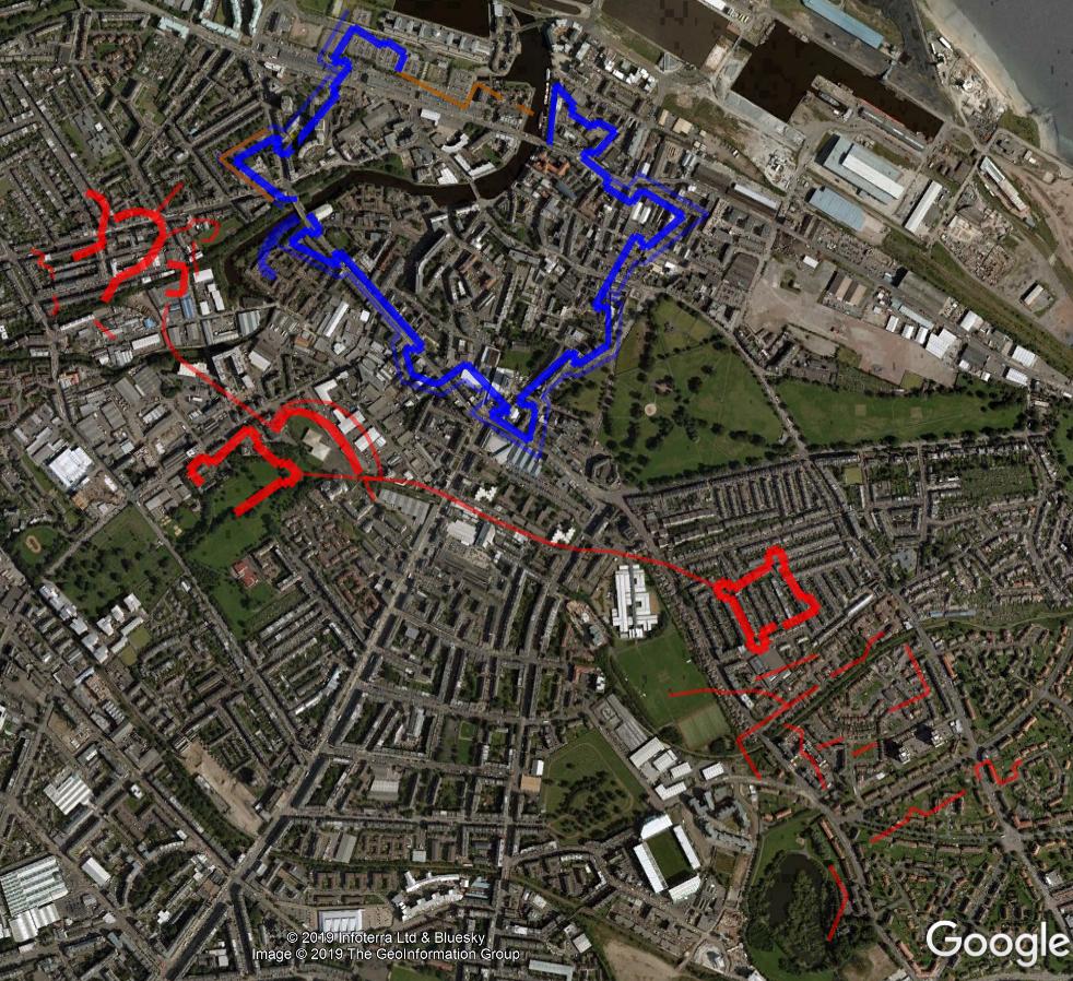
You can see from this that yes, those 2 hills on the Links are nothing whatsoever to do with the siege positions.
The boundaries of Leith Mount, a former villa house and grounds, was also defined by one of the bastions with their distinctive arrowhead form. The ground is now occupied by Leith Library / Theatre and the care home in grounds of former "DK" High School


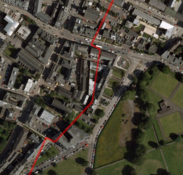
The more you look again at the street plan of Leith (before modern redevelopments), the more the pentagonal outline of Cromwell's Citadel is just blindingly obvious.

Even on the modern map.

We can be fairly sure where the key features of the outside of the Citadel were from documentary descriptions, and handily a little bit of it remains! The east-facing entrance port and wall fragments remain to this day.


And the early 19th c. maps record the outline of the southern ramparts and bastions, as well as reference to "Cromwell's Dyke" (one of the inner wall faces perhaps?)

Roy's maps (1750s) suggest the Citadel was more of a diamond shape, but I think that's probably because the northern face was on the shoreline and therefore didn't require such significant fortification and thus there were only 3 corner bastions to the west, south and east.


Maybe something like this then