#30DayMapChallenge
Map 1: Points
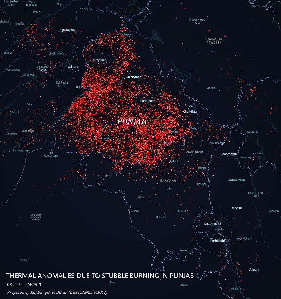
Thermal anomalies observed across Northern India in the last one week. These are primarily stubble-burning crop fire incidents in #Punjab.
Map 1: Points
Thermal anomalies observed across Northern India in the last one week. These are primarily stubble-burning crop fire incidents in #Punjab.
#30DayMapChallenge
Map 2: Lines (Only one line though 😋)
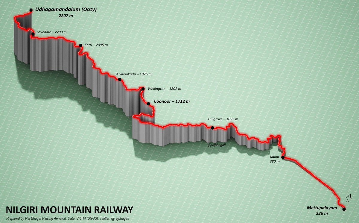
#Viz shows the elevation profile of Nilgiri Mountain Railway in Tamil Nadu which is an UNESCO world heritage site
Map 2: Lines (Only one line though 😋)
#Viz shows the elevation profile of Nilgiri Mountain Railway in Tamil Nadu which is an UNESCO world heritage site
#30DayMapChallenge
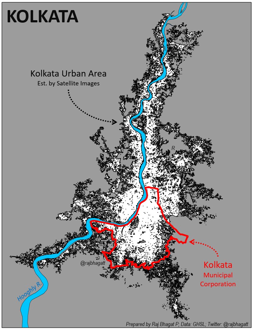
Map 3: Polygons
#Map shows 3 Polygon layers for #Kolkata City
1. Municipal corporation -in 🔴
2. Kolkata Urban Area -Satellite est. -in ⬛️
3. Hooghly River -in 🔵
DYK: More than 2/3rds of Kolkata's urban agg population lives outside the Kolkata Corporation?
Map 3: Polygons
#Map shows 3 Polygon layers for #Kolkata City
1. Municipal corporation -in 🔴
2. Kolkata Urban Area -Satellite est. -in ⬛️
3. Hooghly River -in 🔵
DYK: More than 2/3rds of Kolkata's urban agg population lives outside the Kolkata Corporation?
#30DayMapChallenge
Map 4: Hexagons
#Map shows the religious landscape of #Kerala. The colour of the hexagon denotes the share of places of worship belonging to each religion.
Red-Hinduism; Blue-Christianity; Green - Islam
Created with @osm_in data on places of worship
Map 4: Hexagons
#Map shows the religious landscape of #Kerala. The colour of the hexagon denotes the share of places of worship belonging to each religion.
Red-Hinduism; Blue-Christianity; Green - Islam
Created with @osm_in data on places of worship

#30DayMapChallenge
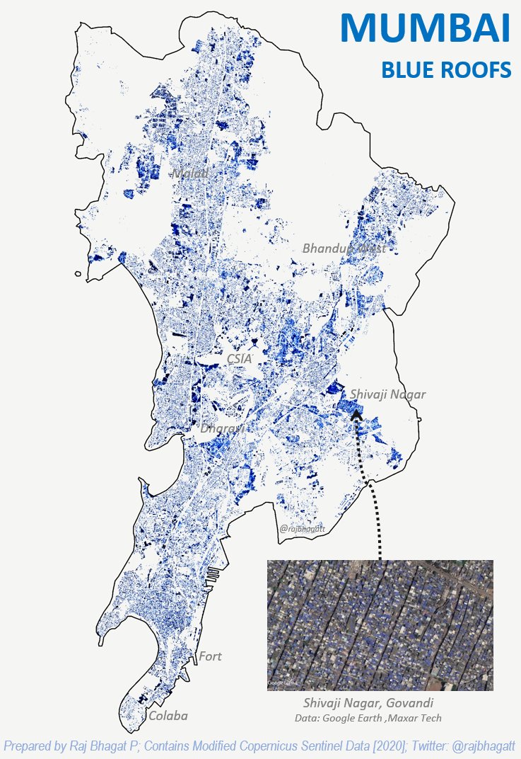
Map 5: Blue
Blue domintes #Mumbai's roofing scene. Map shows areas where blue coloured roofs are prevalent. Created based on a simple processing of @CopernicusEU Satellite images
More:
Map 5: Blue
Blue domintes #Mumbai's roofing scene. Map shows areas where blue coloured roofs are prevalent. Created based on a simple processing of @CopernicusEU Satellite images
More:
https://twitter.com/WRIIndia/status/1319165743804469248
#30DayMapChallenge
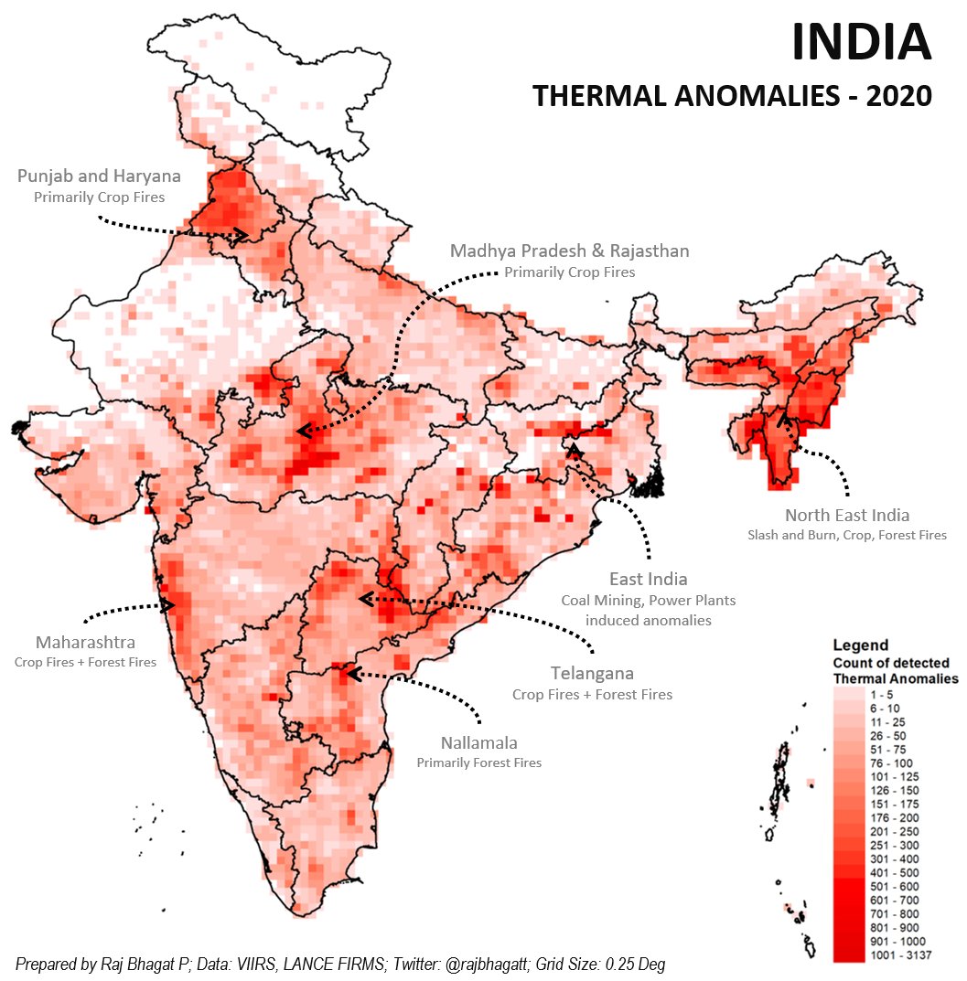
Map 5: Red
#Map shows thermal anomalies detected over India in 2020. Includes various causes such as Crop fires, Forest fires, power plants, and even landfill fires. Remember - 2 more months to go.
MadhyaPradesh is one of the leaders but hardly gets noticed
Map 5: Red
#Map shows thermal anomalies detected over India in 2020. Includes various causes such as Crop fires, Forest fires, power plants, and even landfill fires. Remember - 2 more months to go.
MadhyaPradesh is one of the leaders but hardly gets noticed
#30DayMapChallenge
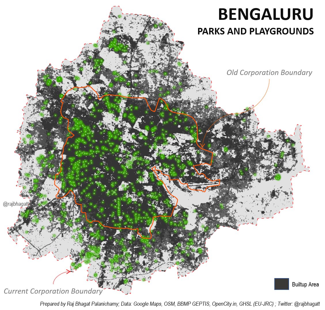
Map 7: Green
#Map shows locations of ~1400 parks & playgrounds in #Bengaluru using GMaps, OSM, BBMP lists etc shown with backdrop of builtup area. Most of the well maintained parks are within old corp. Lakes, Private spaces fulfill the requirements outside
Map 7: Green
#Map shows locations of ~1400 parks & playgrounds in #Bengaluru using GMaps, OSM, BBMP lists etc shown with backdrop of builtup area. Most of the well maintained parks are within old corp. Lakes, Private spaces fulfill the requirements outside
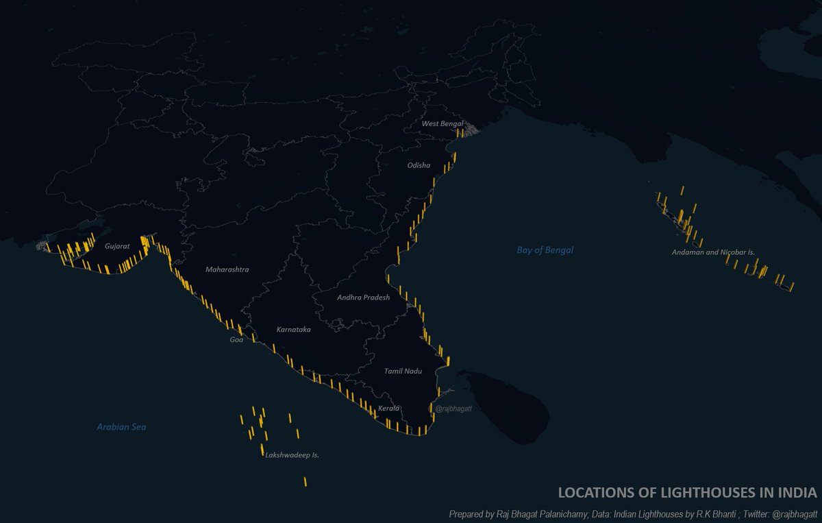
#30DayMapChallenge
Map 8: Yellow
#Map shows locations of lighthouses in India. 170 Lighthouses have been marked in this.
Map 8: Yellow
#Map shows locations of lighthouses in India. 170 Lighthouses have been marked in this.
#30DayMapChallenge
Map 8: Monochrome
#Viz shows exaggerated elevation of Inter-Tidal zone in Kutch (Gujarat) between Mundra & Kandla. The sea oscillates as much as 5 Kms in certain sections between high & low tides. This month the sea level due to tide varied by 7 meters!
Map 8: Monochrome
#Viz shows exaggerated elevation of Inter-Tidal zone in Kutch (Gujarat) between Mundra & Kandla. The sea oscillates as much as 5 Kms in certain sections between high & low tides. This month the sea level due to tide varied by 7 meters!

#30DayMapChallenge
Map 10: Grid
#Viz shows locations where cyclones, depressions start! Colour denotes the number of the systems that started in the respective grid cell (Size: 0.25 deg). Based on IMD data
Map 10: Grid
#Viz shows locations where cyclones, depressions start! Colour denotes the number of the systems that started in the respective grid cell (Size: 0.25 deg). Based on IMD data

#30DayMapChallenge
Map 11: 3D
#Viz of Bengaluru shows elevation profile of the city based on processing and digitizing multiple satellite images. The grey dots are buildings that could be classified/identified (A million objects are there)
Repost :)
Map 11: 3D
#Viz of Bengaluru shows elevation profile of the city based on processing and digitizing multiple satellite images. The grey dots are buildings that could be classified/identified (A million objects are there)
Repost :)

#30DayMapChallenge
Map 12: Map not made with GIS Software
#Map was prepared with Microsoft Excel and shows India's vegetation (as measure of EVI). This was created by adjusting formatting of cell (BG & Font colour). Inset shows @msexcel sheet
Anything can be used to make a map!
Map 12: Map not made with GIS Software
#Map was prepared with Microsoft Excel and shows India's vegetation (as measure of EVI). This was created by adjusting formatting of cell (BG & Font colour). Inset shows @msexcel sheet
Anything can be used to make a map!

#30DayMapChallenge
Map 13: Raster
No! It's not a convoluted rainbow..
#Viz shows the lower course of Kosi River in #Bihar where different colours indicate the course of the river in different years. The river is one of the most dynamic!
Map 13: Raster
No! It's not a convoluted rainbow..
#Viz shows the lower course of Kosi River in #Bihar where different colours indicate the course of the river in different years. The river is one of the most dynamic!

#30DayMapChallenge
Map 14: Climate Change
One of the glacial lakes in Sikkim, Lhonak has been expanding since 1960s. So far, lake has grown by 2 Kms as detected by multiple satellite images.
#Viz shows 3D view as in GoogleEarth. Inset shows glacial lake in old satellite image
Map 14: Climate Change
One of the glacial lakes in Sikkim, Lhonak has been expanding since 1960s. So far, lake has grown by 2 Kms as detected by multiple satellite images.
#Viz shows 3D view as in GoogleEarth. Inset shows glacial lake in old satellite image

#30DayMapChallenge
Map 15: Connections
Viz shows internet upload speed as in second quarter 2020 from @Speedtest. At this point , I am convinced that temporal comparison of this data would help monitor Urbanization in #India!
Map 15: Connections
Viz shows internet upload speed as in second quarter 2020 from @Speedtest. At this point , I am convinced that temporal comparison of this data would help monitor Urbanization in #India!

#30DayMapChallenge
Map 16: Island(s)
River #Kaveri has a lot of islands in it. Three of the largest islands host a Ranganathaswamy temple in them (marked in orange). 2 of the 3 islands are named in similar fashion (#srirangam) & the other has waterfalls on either side!
#cauvery
Map 16: Island(s)
River #Kaveri has a lot of islands in it. Three of the largest islands host a Ranganathaswamy temple in them (marked in orange). 2 of the 3 islands are named in similar fashion (#srirangam) & the other has waterfalls on either side!
#cauvery

#30DayMapChallenge
Map 17: Historical Map
During World War I, German Cruiser SMS Emden raided Indian Ocean & bombed Madras (#Chennai) making it only site of WWI in India
The ship was so feared that d word "Emden" entered Tamil & other lngs' lexicon. meaning: tough, street smart
Map 17: Historical Map
During World War I, German Cruiser SMS Emden raided Indian Ocean & bombed Madras (#Chennai) making it only site of WWI in India
The ship was so feared that d word "Emden" entered Tamil & other lngs' lexicon. meaning: tough, street smart

#30DayMapChallenge
Map 18: Landuse
#TamilNadu uses nearly 6% of it's land to artificially store water in the form of tanks & lakes (around 45000). This is the highest for any state. Inset shows parts of Ramanathapuram, Sivagangai, Pudukottai dists which have high concentration
Map 18: Landuse
#TamilNadu uses nearly 6% of it's land to artificially store water in the form of tanks & lakes (around 45000). This is the highest for any state. Inset shows parts of Ramanathapuram, Sivagangai, Pudukottai dists which have high concentration

• • •
Missing some Tweet in this thread? You can try to
force a refresh