
Europe has cleared out, the Western Sahara plume has finally slowed down to a crawl and the Leviathan low (as I call it remains in place over the Black Sea. Also there is an interesting burst of activity in the Horn of Africa.
Today's #NorthAfrica & #MiddleEast forecasts follow.
Today's #NorthAfrica & #MiddleEast forecasts follow.
As you can see in this animation there was some intense convection over the the #Ethiopian highlands and Sudan today, certainly more than we have seen for a fair few days.
Here we see a wider angle view of today' convection over the horn before sunset. This storm is continuing strongly into the night. Question of the day is, is this signalling the beginning of the big rainy season for the horn.
This animation relates to the wider picture in the tweet before last and it also relates to the big rains. In this animation at the end you see at the end that the picture stabilises with steady mid-altitude winds (10kms) from India to the horn.
The animation is from the GFS model and covers 10 days. These three show slightly low altitude winds 300hpa vs 250hpa in the GFS in 10 days time. All four models see the position stabilising - and I think this is what we are looking for to power the big rainy season. 


Here are today's 12-day and 10-day rainfall forecasts for the broader region. The first one you see is the 12-day KMA forecast. The other three are 10 day forecasts. Significant amounts of rain are falling north of the 15 degree line both the KMA and CMC forecasts now.


And speaking of rain heading north this animation shows clouds sending moisture north from the large storm over the horn today.
Here are three 48 hour forecasts for #NorthAfrica which include the rain clouds shown heading north up the Sudanese Red Sea Coast in the previous tweet.


10-Day rainfall forecasts for June 14th of the #HornOfAfrica including, #Somalia, #Somaliland, #Djibouti, #Ethiopia and parts of #Sudan and #SouthSudan.
+ bonus 12-day forecast from KMA.
+ bonus 12-day forecast from KMA.


48 hour rainfall forecasts for June 14th of the #HornOfAfrica including #Somalia, #Somaliland, #Djibouti, #Ethiopia and parts of #Sudan and #SouthSudan.


The Arabian Peninsula was quieter today than it has been since the beginning on June with just a few small clouds forming over Oman and the Yemen Red Sea Coast.
10-Day June 14th, accumulated rain forecasts for the #MiddleEast from the GFS, CMC & KMA weather models.
#ArabianStorms
#KSA #Yemen #Oman #Jordan #Sudan #Iran #Syria #GERD #Sudan #DesertRain
الله أعلم
#ArabianStorms
#KSA #Yemen #Oman #Jordan #Sudan #Iran #Syria #GERD #Sudan #DesertRain
الله أعلم


48 Hour June 14th (today and tomorrow), accumulated rain forecasts for the #MiddleEast from the GFS, CMC & KMA weather models.
#ArabianStorms
#KSA #Yemen #Oman #Jordan #Sudan #Iran #Syria #GERD #Sudan #DesertRain
الله أعلم
#ArabianStorms
#KSA #Yemen #Oman #Jordan #Sudan #Iran #Syria #GERD #Sudan #DesertRain
الله أعلم


. @Arab_Storms has no new live storm videos from the Arabian Peninsula for today but he does have some spectacular ones from Europe over the past few days. The first is from Spain yesterday.
https://twitter.com/Arab_Storms/status/1404176600686604299?s=20
This one is from Ukraine yesterday.
https://twitter.com/Arab_Storms/status/1404171278513229825?s=20
And this one is also from Spain.
https://twitter.com/Arab_Storms/status/1404496377439207429?s=20
There were further significant storms in Northern Spain today. as you can see in this satellite animation. And while things are a lot quieter than they have been recently over Morocco, there is still a fair bit going on.
Also as these images show. Just because you can't see clouds, that doesn't mean that water is not moving through the area.

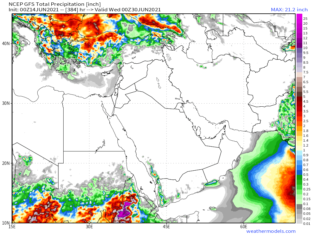
And finally, June 14th 16-day (GFS) and 12-day (KMA) accumulated rainfall forecasts for the Middle East.
The GFS is again showing rains over the Arabian Sea getting very close to Yemen. This 16 day forecast also shows very heavy rains in #Ethopia in bottom left.
The GFS is again showing rains over the Arabian Sea getting very close to Yemen. This 16 day forecast also shows very heavy rains in #Ethopia in bottom left.

/ENDS
@Threadreaderapp unroll
@Threadreaderapp unroll
• • •
Missing some Tweet in this thread? You can try to
force a refresh


