
This week's rainfall forecasts for the #HornOfAfrica, #NorthAfrica and the #Middle East follow.
Image: Typhoon INFA over China showing the lights of Tokyo where the world is gathered to celebrate youth & excellence and the unity of the nations of the world at the Olympics.
Image: Typhoon INFA over China showing the lights of Tokyo where the world is gathered to celebrate youth & excellence and the unity of the nations of the world at the Olympics.
Here we see Japan again and tropical storm #Nepartak which is on route towards the Olympics.
#Nepartak is a child of #INFA's gyre and you can see an atmospheric river coming from #INFA's outflows which leads directly to her.
#Nepartak is a child of #INFA's gyre and you can see an atmospheric river coming from #INFA's outflows which leads directly to her.
This weekly thread is the sequel to the daily threads published April-July in solidarity with the efforts to complete the 2nd filling of the #GERD dam under difficult circumstances.
There hasn't been a clear view of the #GERD in the past week sadly, just a glimpse.
There hasn't been a clear view of the #GERD in the past week sadly, just a glimpse.


Today's picture showing the big picture.
1. The Indian Monsoon is still sending a lot of moisture west.
2. #ArabianStorms continue on a daily basis
3. The Ethiopia Highlands rains remain intense.
1. The Indian Monsoon is still sending a lot of moisture west.
2. #ArabianStorms continue on a daily basis
3. The Ethiopia Highlands rains remain intense.

Here we see a 10 day animation of PWAT over North Africa from the CMC model.
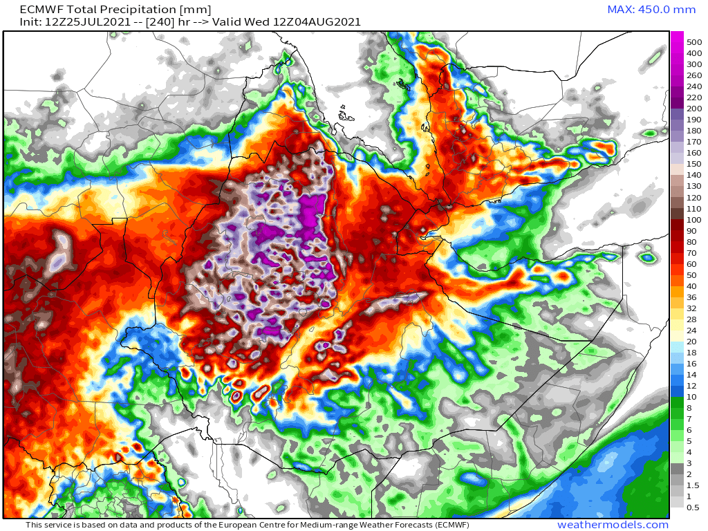
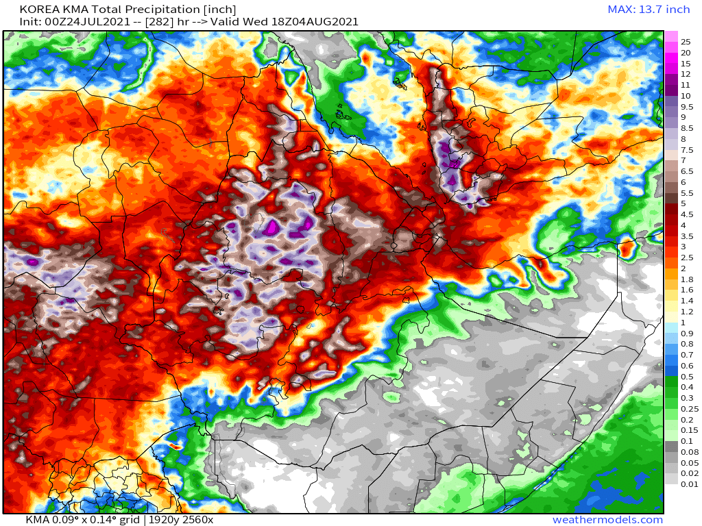
Today's 10-Day Rainfall forecasts for North Africa from July 25th through August 3rd.
GFS, ECMWF, CMC and KMA models.
GFS, ECMWF, CMC and KMA models.


48-hour #NorthAfrica rainfall forecasts (today and tomorrow from the same 4 models).


Finally for #NorthAfrica we have the long-range 16-day (GFS) and 12-day (KMA) forecasts


A 24 hour animation of clouds and storms over the Arabian Peninsula and Horn of Africa today.
This is a new plot, a ten day Ethiopian Precipitable water forecast. This forecasts the quantity of water that is in the atmosphere over the #HornOfAfrica, this is where the rainfall comes from. There is a correlation between presence of water and rainfall intensity.
This PWAT forecast from the same model (Australia's ACG model) shows a wider view including the source of the water the Indian Monsoon.
It suggests rainfall will be heaviest over the next few days and decline at the beginning of next week.
It suggests rainfall will be heaviest over the next few days and decline at the beginning of next week.
Today's July 25th 10-day rainfall forecasts for #Ethiopia (+1 12-day from KMA) and the #HornOfAfrica: #Somalia, #Somaliland, east #SouthSudan, south east parts of Sudan, #Djbouti and #Eritrea.
Purple heaviest rain covers #Tigray, & #Abbay (#GERD) & #TekezeAtbara basins.
Purple heaviest rain covers #Tigray, & #Abbay (#GERD) & #TekezeAtbara basins.


48 Hour forecasts (today and tomorrow) from the same three models.
NOTE: The ten day forecasts suggest the levels of rain over Ethiopia's Highlands will continue at their intensity of roughly 1 inch per day across the entire catchments.
NOTE: The ten day forecasts suggest the levels of rain over Ethiopia's Highlands will continue at their intensity of roughly 1 inch per day across the entire catchments.


This animation shows the #ArabianStorms on July 23rd towards the tail end of the #ArabianMonsoonBurst.
And for the July 24th
And July 22nd...
And with the 21st we complete the record back to the last daily forecast report on the 20th.
The #ArabianMonsoonBurst is now in its 10th day. The Attached thread is from the 1st day July 15th & the hashtag will lead you to the other threads.
The #ArabianMonsoonBurst is now in its 10th day. The Attached thread is from the 1st day July 15th & the hashtag will lead you to the other threads.
https://twitter.com/althecat/status/1415697217680248835?s=20
Rainfall over this period in the Arabian Peninsula is as far as I am aware unprecedented and almost certainly a sign of climate change in the region.
In the Nile basin rainfall has been unusually widespread, intense, has continued through the night.
In the Nile basin rainfall has been unusually widespread, intense, has continued through the night.
It is probable this is the reason for the unusually high flows reported by Sudan at the Merowe dam this week. There is a high risk that significant Nile flooding may occur this year, especially if this pattern continues. This has all the hallmarks of an extreme weather event.
That said I am not a meteorologist and have no access to the flow data which is a much better way to understand the level of threat this poses. @TirusewAsefa may be able to help with this.
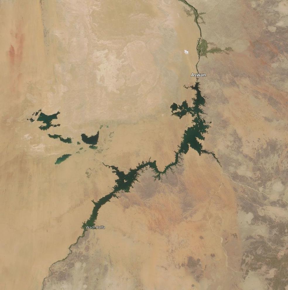
For some time I have been concerned about the very high levels of the Aswan Dam.
For some time I have been concerned about the very high levels of the Aswan Dam.
Here we see satellite images, left today, and right 25th of June. I have no expertise in reading these images but they may show that the dam level has been reduced to enhance the dam's capacity to manage the flow surge which is coming Egypt's way.

The final forecast segment addresses the #MiddleEast.
July 25th 10-Day accumulated rain forecasts for the #MiddleEast from the GFS, CMC, KMA & ACG weather models.
#ArabianStorms
#KSA #Yemen #Oman #Jordan #Sudan #Iran #Syria #GERD #Sudan #DesertRain #UAE
الله أعلم
July 25th 10-Day accumulated rain forecasts for the #MiddleEast from the GFS, CMC, KMA & ACG weather models.
#ArabianStorms
#KSA #Yemen #Oman #Jordan #Sudan #Iran #Syria #GERD #Sudan #DesertRain #UAE
الله أعلم


48 Hour July 25th (today and tomorrow), accumulated rain forecasts for the #MiddleEast from the GFS, CMC, KMA and ACG weather models.
#ArabianStorms
#KSA #Yemen #Oman #Jordan #Sudan #Iran #Syria #GERD #Sudan #DesertRain
الله أعلم
#ArabianStorms
#KSA #Yemen #Oman #Jordan #Sudan #Iran #Syria #GERD #Sudan #DesertRain
الله أعلم


From these forecasts we can deduce that the unusual rainfall weather on the Peninsula and Sudan is not yet finished.
And finally we have today's long-range #MiddleEast July 25th rainfall forecasts.
The16-day GFS & GEFS models, the 12 day KMA and the 15 day EPS (Euro ensemble) model forecasts.
الله أعلم
The16-day GFS & GEFS models, the 12 day KMA and the 15 day EPS (Euro ensemble) model forecasts.
الله أعلم


A quick look at @Arab_Storms compilation of flooding eyewitness reports from the past two days leaves me feeling stunned.
Extreme weather appears to be underway everywhere.
I would suggest that readers go and see for themselves >> twitter.com/Arab_Storms
Extreme weather appears to be underway everywhere.
I would suggest that readers go and see for themselves >> twitter.com/Arab_Storms
Here @Arab_Storms is keeping track of the fatality count, which is growing rapidly.
https://twitter.com/Arab_Storms/status/1418878823546884103?s=20
Translation: According to a United Nations report, climate change has killed more than one million people in the past 50 years. Our world is getting warmer by the day and these heavy rains are a sign of climate change.
https://twitter.com/Arab_Storms/status/1418860258387189770?s=20
We now move to a big picture view. North Western Hemisphere zero hour simulation data (i.e. now).
1. Precipitable water PWAT anomaly
2. PWAT (potential rain + energy)
3. MLSP (Mean Sea Level Pressure)
4. 250Hpa (jet stream winds approx 11-15 kms high)
1. Precipitable water PWAT anomaly
2. PWAT (potential rain + energy)
3. MLSP (Mean Sea Level Pressure)
4. 250Hpa (jet stream winds approx 11-15 kms high)


And that's it folks.
We are in a wide world of weird weather together. That much is becoming very clear.
/ENDS
@Threadreaderapp unroll
We are in a wide world of weird weather together. That much is becoming very clear.
/ENDS
@Threadreaderapp unroll
• • •
Missing some Tweet in this thread? You can try to
force a refresh


