,
67 tweets,
8 min read
Read on Twitter
A Houston floodsplainer:
(caveat, I'm not a pro, just someone interested in how my city works. If a real pro finds an error, please LMK)
(caveat, I'm not a pro, just someone interested in how my city works. If a real pro finds an error, please LMK)
There will inevitably be extreme hottakes regarding flood planning and monday-morning QB-ing of officials. This is for context
Houston is on a flat, mostly featureless plain, which is naturally drained by a number of Bayous ("The Bayou City" refers to HTX, not NOLA) 
which all run (and drain) from west to east, converging on either the ship channel or San Jacinto Bay
Note the scale: HTX is also geographically enormous
It also has varying development density. Here's a sat pic which will roughly show that
It also has varying development density. Here's a sat pic which will roughly show that
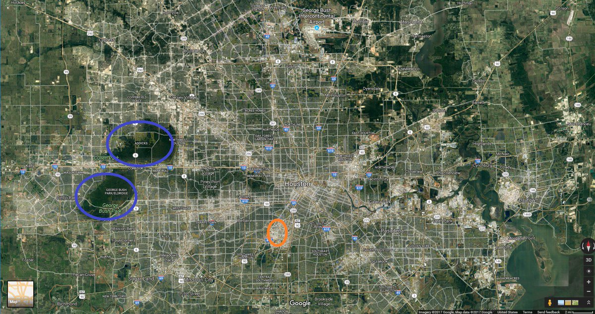
(Note: I've highlighted 2 areas- Addicks & Barker reservoirs and the medical center, because I'll mention them later)
HTX has sandy soil and a high water table, and so has some, but limited, ability to rely on absorption
(related: No houses have basements and it would be nearly impossible to construct a subway)
Most of HTX is ~35-45' above sea level. Flooding risk is almost entirely from rain, not storm surges
Being Gulf Coast, HTX gets ~50" of rain a year. Gulf T-Storms can get intense. 4-6"-in-8-hours storms happen about once a year
flooding is essentially a rate problem- can you drain the water as fast as it comes?
when the answer is 'no', water backs up along the drainage routes

as a result, any person's flooding risk is mainly about proximity and elevation vs the nearest bayou
The primary backup for the bayous for handling too much water are the roads
In the 90s. Houston was getting large enough that relying on groundwater was starting to cause subsidence problems
The powers that be decided (wisely, mostly) to slowly convert all the roads into a giant rain collection network
so every time an asphalt road needed to be repaved, it got replaced with curb & gutter concrete w/ big storm sewer underneath
this has been highly obnoxious to anyone living nearby when such a project was underway but ultimately quite effective
usually means that in flooding situations, roads briefly become rivers and then drain, saving houses from flood damage
but it's also a work in progress that has proceeded at the rate roads needed replacing, and varies greatly by location
the next backup for water are sections of freeways. Here, e.g. is a section of I-69/US-59 (as indicated on map)

given the flood risk indication of the neighborhood immediately south, that sunken section serves a flood-relief purpose:

Thus, flood control in HTX is and has been in a continual state of upgrade for 20 years
However HTX has also been growing rapidly in that time, adding about 100-125k people/year for 15 years
with the result that at any given time the flood control has been adequate, but for the city T-5 years ago, not now
with the currently least-adequate parts usually around the geographic periphery and immediately downstream
The key incidents forming city officials' decision making have been the experiences of Allison (2001), Rita (2005), Ike (2008)
and the flooding events of the past 2 years (Memorial Day 2015 and Tax Day 2016)
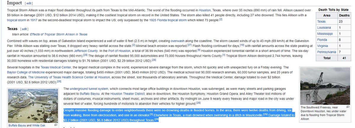
Conceptually, Harvey is closest to Allison, which was a TS that parked itself over HTX for 3 days and dumped 20" rain
en.wikipedia.org/wiki/Tropical_… . The key point:
Rita (2005) was a huge storm, occurring ~1 month after Katrina. For a few days it was forecast to hit Houston directly
but it ultimately drifted eastwards and hit Port Arthur
given the recent experience of Katrina, an evac was (very understandbly) ordered. The result:
Hurricane Ike (2008) is least directly relevant- in Houston it caused immense damage but comparatively little flooding and death
..except in the medical center, which lost power, and sustained lots of flood damage
doctorflood.rice.edu/SSPEED_2008/do…
doctorflood.rice.edu/SSPEED_2008/do…
The med center is an utterly critical component of Houston, and understandably a high priority for flood control
It employs ~150k people, conducts enormous amounts of cutting-edge research
and most importantly, at any given time has a large number of very sick, very immobile patients
it has therefore received (again, understandably) disproportionate flood-control attention in the past decade
... but often at the expense of other areas in the city
The other section I highlighted was the Addicks & Barker reservoirs. swg.usace.army.mil/Missions/Dam-S…
They are flood control reserviors that date from the 30s. They remain highly useful and functional
but given Houston's growth are now inadequate to the nearby area, which is where the worst flooding in Allison occurred
They are the focus of the Texas Trib article linked above, and I'd guess that's where the worst flooding will happen this time
With all that background, now for the city's Harvey choices: As of mid-last week, it was forecast that Harvey would produce
"up to Allison" levels of rainfall. That was when any evac order would have had to be made
It's not possible to evac all of Houston inside of 48 hours. Too many people, not enough roads or time
and Houston would inherently be a lower priority than people closer to the coast
City & state leaders knew the rainfall would be very, very bad. But the experiences of Allison & Rita would lead to the belief
.. that evacuation, esp on short notice, would lead to more death than hunkering down.
Also, given that roads & freeways food BY DESIGN, "stuck on the road" is the absolute worst, most dangerous place to be
thus an evac that stranded people mid-storm would be worst-case scenario
Embedded in that is a gamble that emergency services will be able to rescue people at the rate they become endangered
That's a hard choice to make. and it will be examined for a long, long time given 20/20 hindsight
But decisions have to be judged by the best information available at the time. And at the time, it was justifiable.
Perhaps on closer examination it will have been the wrong choice, but it is an entirely defensible one.
Many have noticed something of a gap a gap between Mayor Turner and Gov Abbott on this choice
and hinted some sort of R/D partisan issue. More relevant is likely the Gov's handicap
(famously, within TX) Gov Abbott is in a wheelchair, and is thus highly sensitive to the risks for people with limited mobility
who of course are/would be in the most danger if hunkering down proves the wrong choice
and so the Gov likely has a different sense of risk than does the Mayor. Doesn't make it right or wrong
just a different value judgement. Judgement calls are as much about being able to live with a choice being wrong
as they are about picking the outcome one thinks will be best. It's easy to see both sides of this one
a correction: as several people have noted, the soil is more clay than sand. Clay still does not absorb well, so larger point stands
Addendum: Bill King, who narrowly lost to Turner for mayor, emphatically says Turner made the right call nytimes.com/2017/08/28/opi…
Add. 2, @MichaelBerrySho, fmr councilman, & frequent Turner critic also 100% agreed on no-evac call