,
26 tweets,
5 min read
Read on Twitter
This is David. King David I of Scotland (1124-1153). It's with David that the history of Leith gets going, and his decisions as supreme ruler set the foundations for the development of Leith for the next 500 or so years. 

From about the age of 10, David was raised in the English court, so effectively was raised in the Norman court, and he took the Scottish throne by force with the backing of England in 1124.
As part of his campaign to exert authority and pacify his hard-fought kingdom, he did a couple of things. Firstly, he founded Holyrood Abbey in 1128. Secondly, he invited Anglo-Norman friends from the English court to take up Baronies in Scotland. One one of these was Peter
To Holyrood Abbey he granted "his" (he was King, so everything was his to give away) lands of Inverleith (Gaelic, mouth of the Water of Leith), half of its fishing and fish taxes and its harbour to the monks.
At that time, the mouth of the water of Leith was a proper tidal river mouth, much wider than it is today and with no harbour structures. The harbour was a bit of the shore on the south bank (now where the Coal Hill is) where boats could be hauled in and launched
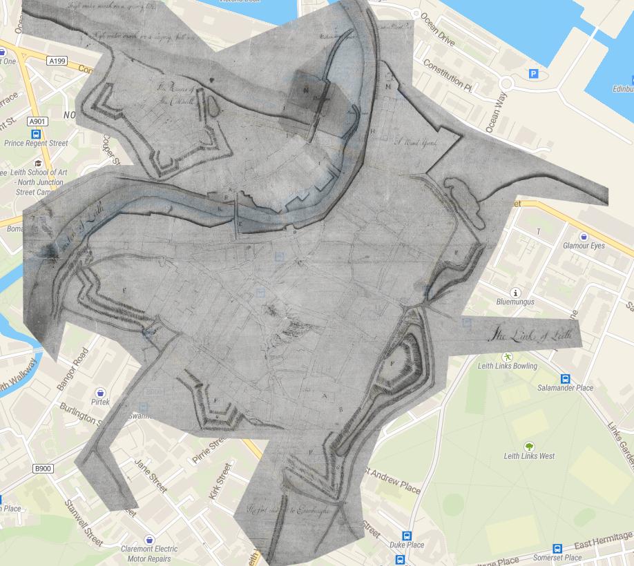
So by giving the harbour to Holyrood Abbey, whose lands would become North Leith, he creates that odd salient of North Leith that sits on the "wrong" side of river in South Leith (Kirkwood's map of 1817 highlights this parish boundary nicely)

Back to his pal, Peter. Peter was given the lands of Lestalric (Restalrig) as a barony. That is, Peter was the Baron of Restalrig, held the lands for the crown, and had powers of law and taxation and that sort of thing so long as he supported the crown etc.
The Lestalric lands included most of Leith to the south and east of the river, and all the lands we now think of as Craigentinny, Lochend, Restalrig etc. So the community of South Leith was part of Restalrig and not the other way around.
The Lestalrics built a church near their seat at Lochend Castle, which is where Restalrig parish church still is today. That became the church for South Leith, a wee bit of a walk, but less than the parishioners of North Leith had to make as they went to Holyrood Abbey to worship
The King (David I), having given away his principal harbour, simply made himself a new one by keeping a little bit of the shoreline to himself. Round about where the Malt & Hops pub currently is.
Both North and South Leith developed on the "toft" system, where the land was drawn up into a series of farming strips, headed by a house, rented from the superior (the Abbey or the Lestalrics respectively). Surrounding lands were worked as common grazing or for the superior
So by the mid-12th century, you have North Leith and the harbour (yellow) held by Holyrood Abbey, the King's land is in Blue, the Lestalric's land in red and the tofts they granted in South Leith in paler red.

(that map is adapted from a sketch in Sue Mowat's wonderful book "The Port Of Leith", you won't find a better reference on the subject)
And so life proceeds in this vein for a few centuries, war, pestilence and famine keeping things in check, until in 1398 the then (9th, probably) Baron Restalrig, Robert Logan (I), does something silly and sells a strip of shore and wide-ranging rights to the Burgh of Edinburgh
The Logans hailed from Ayrshire way and Robert Logan (I) came into possession of Restalrig in as his father had married the daughter of the last de Lestalric. When he in turn died in 1439, he had no surviving son and his possessions were split amongst 4 grandsons
Logan's eldest grandson, John Logan, took the Barony of Restalrig and with it South Leith (except the bits held by Edinburgh). His 2nd Grandson took the estate of Coatfield (remember Coatfield Lane/Look at Leith), including the Links
Now, sir John Logan also held the title Sheriff of Edinburgh, which had passed to him with the Barony of Restalrig. So he gives this, and the lands on the south bank of the river to the west of the Church's land to his son, who builds a big hoose on the high ground.
And so we come to how the Sheriff ("Shirra" was the local term) Brae got its name, it was the hill on which the Sheriff of Edinburgh built his house.
By no means accurate, but roughly by the start of the 16th century we have the lands of Leith held by the Abbey (yellow), Logans of Restalrig (red), Logans of Coatfield (purple), Logans of Shirrabrae (orange), the crown (blue) and Burgesses of Edinburgh (green)

Skipping back 100ish years to the blue lands of the Crown, in 1434 Kings James I has constructed a defensive work (or wark in Scots); hence the "King's Wark". Basically a defensive 3-storey blockhouse to hold an arsenal and the Crown's personal stores brought ashore here.
In 1604, James VI grants part of the lands of the King's Wark to one Bernard Lindsay, who is also given the hereditary office of Baillie. Edinburgh purchased this from the Lindsay's in 1623 and the street later formed there became Bernard Street.
So last but not least, how about the Coal Hill? Well that was part of the lands held by Edinburgh, who controlled all the trade in and out of Leith, and coal was no exception. Coal was vital, and came by ship given how terrible the roads were.
In 1797, the Lord Provost of Edinburgh ordered that any ship bringing in coal was immediately to be given a berth at the Coal Hill, any other vessels making way for it, and no shore duties were to be charged to the collier.
So that's the coal bit sorted, but hill? Well if you consider that it was a tidal river, with a shore line much further back (and lower) than currently, relatively speaking the slope that is now the Coal Hill was indeed a bit of a hill (same goes for the brae in Shirrabrae).
And what do we find next to the Coal Hill? But of course, the Peat Neuk! A neuk being the Scots word for a corner, the peat neuk was a place for the storage of peat fuel. Apparently the tollhouse of the old Abbot's Bridge here was converted for the purpose.
The Peat Neuk was somewhat ruinous and allegedly the hangout of "those reckless and abandoned characters who abound in every seaport" and even the "haunt of disembodied spirits, whose crimes or suffering in life compelled them to wander"! 👻