,
27 tweets,
9 min read
Read on Twitter
Look what arrived when I was away...
(yes, this is a copy of the first known town survey of Leith, all the way from the National Archives in Kew)
(yes, this is a copy of the first known town survey of Leith, all the way from the National Archives in Kew)

There's much to get excited about with this amazing old map - although it's not the earliest accurate representation of Leith (Adair shows it in 1682, Grenville Collins in 1693) - it's the first known accurately surveyed town plan of Leith


Having referenced it from the known historical points that still exist today, it's impressively accurate. The map accurately warped to the modern map and that simply given a best fit show little difference.

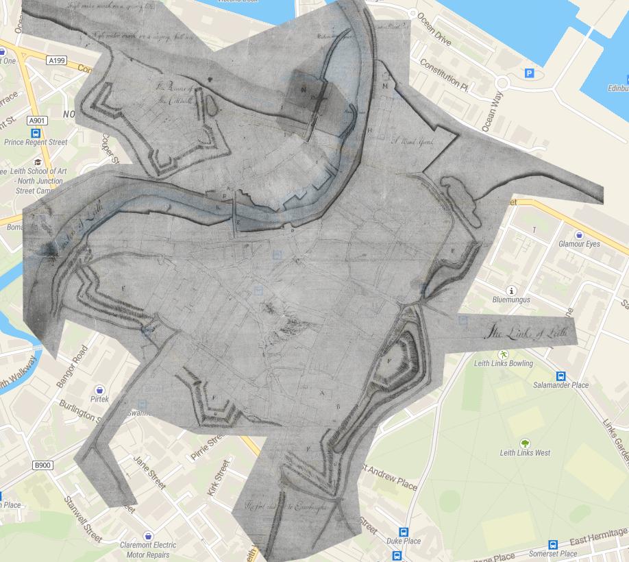
There's so much to go into here. The accuracy of the medieval street plan of Leith for one thing. The remains of the Marian and Cromwellian fortifications for another. The detail of the all important port of Leith... I'll pick a few interesting titbits below for now.
Here we see North Leith Kirk (A) and the burial ground (B), still there today. C is the Tolbooth, D is Mary of Guise's "palace" and E is the 1493 bridge built by Abbot Bellenden (no sniggering at the back). K is the highwater mark.

The gun platforms (F) and bastion ramparts (G) of the French-built Marian defences of 1560 are clearly still there 150 years later, despite orders to have them slighted, as the written evidence suggested.

What is really surprising and exciting to me, is that the defensive ditches to the east of the town are clearly still there too and have flooded into water features.


although they appear to be fed by the town sewers, so were probably not particularly wholesome!
At the south of the Kirkgate, where it meets the "foot road to Edinburgh" we see a bridge. Excitingly, we also see the defensive ditch/bank thrown up by the Covenanter general David Leslie in 1650 between Calton hill and the remains of Leith's walls to repel Cromwell.

Leith Walk was formalised alongside Leslie's fortification. Daniel Defoe described his 1706 visit to it thus; "a very handsome gravel walk, 20 Feet broad, continued to the Town of Leith, which is kept in good repair at the public Charge, and no Horse suffered to come upon it"
Horse and cart traffic to Leith from Edinburgh went via Abbeyhill and the "Eastern" (Easter) Road.
There's an intriguing ring of dots marked on Giles Street, at its modern junction with Spiers Place, and I've no idea what it might be.

At the shore we see stone and wooden sections of the pier recorded, the "key" (quay) at H, I refers to "the bounds of the yard proposed", N was the wooden landing stage, M is the windmill, later the signal tower and O appears to be a planned graving dock.

"A wood yard" refers to the Timberbush, with its unmistakable outline as one of the French bastions (Fort Ramsay). Bush is a corruption of the French Bourse, a yard or exchange. Timber was tipped off ships and floated under the quayside to be stored and traded in the Bush.
All out at sea, the lonely Beacon marked the entrance to the safe, navigable passage. It was a structure of wooden poles and iron, from which a bell and lantern could be hung. As early as 1504, King James IV had a pair of "bekynys" placed here.

And that enticing detail of General Monck's "Cittadell". 3 of the bastions are clear, as is the outer glacis. The inner detail shows the partitioning into buildings and gardens. And the high water mark in a "raging full see" gives a clue as to where the north of the fortress went

I can't find much out about this map. It's a military map, stamped with the symbol of the Board of Ordnance. John Naish was an English surveyor and engineer for the Royal Navy who made surveys of Leith and Queensferry at this time for the Navy with a view to improvements
I wonder if we can assume this was the same John Naish who was soon master shipwright for the Royal Navy at Harwich ?

And then Woolwich. If it is he was certainly a highly skilled surveyor, draughtsman and of course shipbuilder.

I've found out what the dots are! I had a look up of "The Place Names of Edinburgh" (thanks @tormod46!) and it refers to the "green tree growing on the south side of Giles Street at a point now just north of the entry of Spiers Place"

Obviously swept away by the 1849 OS Town Map, it's nevertheless commemorated in one of the names of the tenements in the area cc @Morphington

It's great that Naish seems to have been such an accurate surveyor, as it means we can take some measurements off the map with confidence. The scale of the Marian walls is 12-15m thick surrounded by a ditch 16-20m wide. Excavation in 2012 suggested the ditch was 3.6m deep
That figures, as the ditch needs to be about twice as wide as the rampart if the rampart is twice as high. When you consider that the defences were 3.8km long, totally enclosing the town to all but the sea and beach, you get a real idea of scale and effort
I've not come across a reliable source for the height of the walls, but Victorian polymath David Brewster suggests "up to 20 feet" in the Edinburgh Encyclopædia (depending on the lie of the land). 6 metres in new money, with a 3.6 metre ditch makes a formidable obstacle.
You have to bear in mind that these were not high medieval walls, but modern artillery defences. They are low and thick, to absorb cannon fire, while still providing an obstacle to being scaled, and an advantageous gun platform
This is before the time of mortars and howitzers (weapons that throw their explosive projectile upwards, and over an obstacle), cannons fired solid shot on a flat trajectory. Stone walls would have been a source of shrapnel and tall thin walls were easily breached.
To get an idea of what the fortifications looked like, look no further than @Rob_Marshall's stunning 3D reconstruction of the contemporary Eyemouth Fort along the coast, also held (and remodelled) by the French for Mary of Guise. scharp.co.uk/shoredig-proje…