
The convective storms over Ethiopia and Sudanese Nile Basins tonight is remarkably intense. Bringing massive amounts of rain across a huge area, including the #Abbay /#BlueNile basin, on the 4th day of #GERD filling.
Today's #HOA #ME and #NorthAfrica rainfall forecasts follow.
Today's #HOA #ME and #NorthAfrica rainfall forecasts follow.
In this wider view you can see the full size of today's rain areas which extended deep into Sudan later in the afternoon.
These two images are at sunset the sizes of the two large convective areas, the eastern one extends well north into Eritrea and covers Tigray and the entire #Abbay Basin. The first image provides an idea of size. Each storm area is larger than the UK and Ireland. 


This animation shows the monsoon winds which power this incredible annual precipitation (rainfall) event which runs through to September, and which as we will see later in this forecast bulletin, is about to get much much stronger.
This image shows a satellite based estimate of the amount & locations of rain that fell today in the six hours till 8pm Ethiopia time.

Here's a satellite picture from this morning which again shows a glimpse of the #GERD dam. This will soon be collecting a lot of this rainfall. In terms of Nile flow, the massive amounts of rain falling over Sudan and the Abo catchment in South West Ethiopia is not being caught.


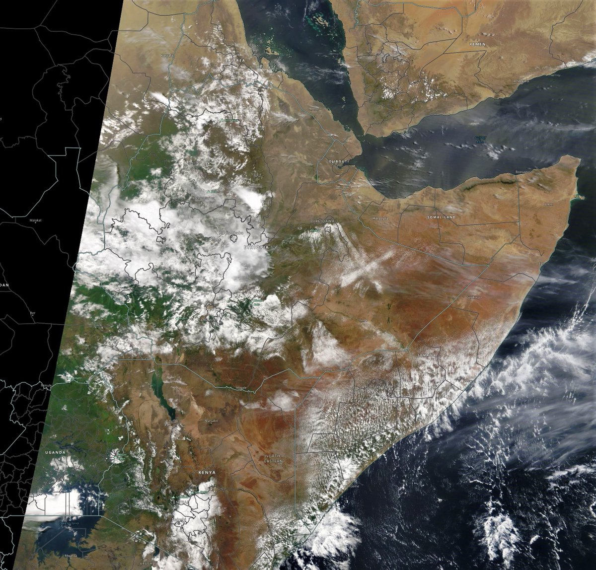
For our big picture today I have zoomed out still further to show #Elsa the first Atlantic hurricane of 2021 (bottom left) as well as the massive incoming mass of cloud heading into Europe. Cloud is also increasing over Yemen.

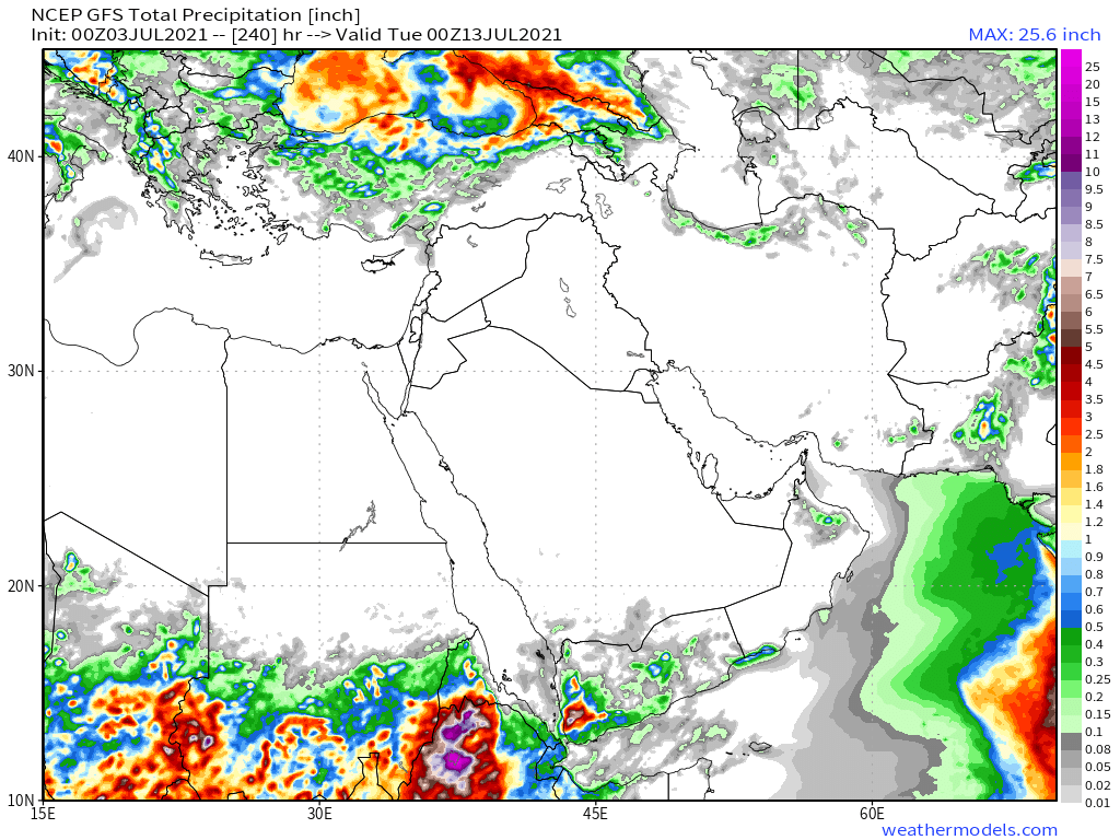
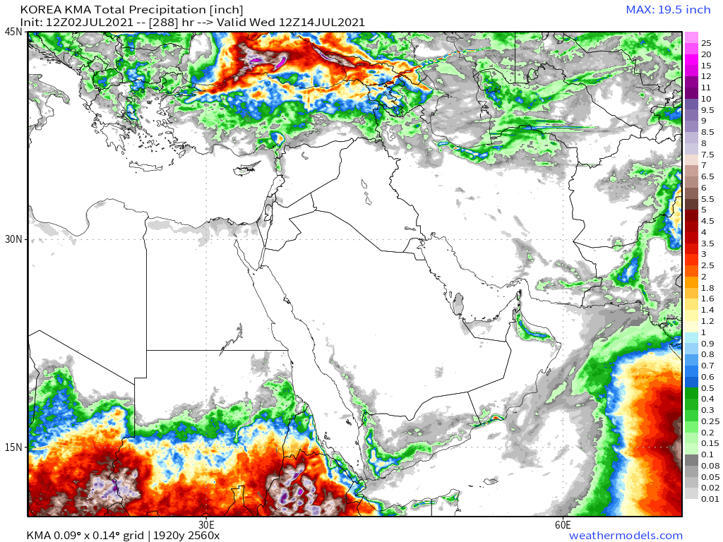
Today's 10-Day Rainfall forecasts for North Africa from July 3rd through July 12th.
[NOTE: The widespread rainfall in the CMC forecast for Yemen is a new feature and supported in the long-range forecast models.]
[NOTE: The widespread rainfall in the CMC forecast for Yemen is a new feature and supported in the long-range forecast models.]


48-hour rainfall forecasts (today and tomorrow from the same four models: the Euro @ECMWF, U.S. @NOAA's GFS, Canada's CMC and Korea's KMA models.
In all forecasts short and long range we now see rainfall pushing deep into northern areas in the Sahel.
In all forecasts short and long range we now see rainfall pushing deep into northern areas in the Sahel.


As the KMA model has not completed its latest runs from the look of things we only have one long-rane rainfall forecast for the wider region today, the 16-day forecast from the GFS.

This animation from this evening shows some of the cloud activity over the Sahel as well as condensing airborn moisture over large swathes of the Western Sahara.
When it comes to understanding Nile River flows, their timing and the volumes of water involved this image (HT @anacascao) is a vital to understanding. Note that these are average flows. But beginning in July flows from the #Abbay river increase spectacularly with the monsoon.

And these GFS forecast images provide us with a glimpse of what is about to happen. They show Precipitable Water in the atmosphere measured in inches. More water=more rain.
In this forecast we can see the monsoon arriving in strength over the horn in roughly 10 days time.
In this forecast we can see the monsoon arriving in strength over the horn in roughly 10 days time.


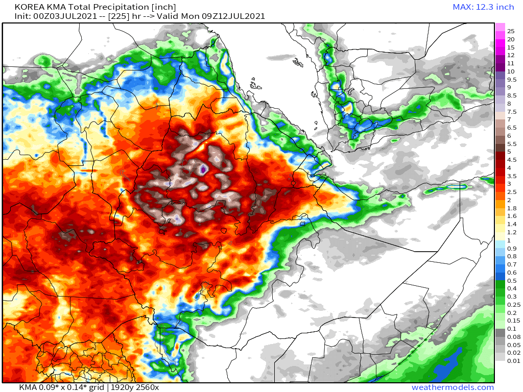
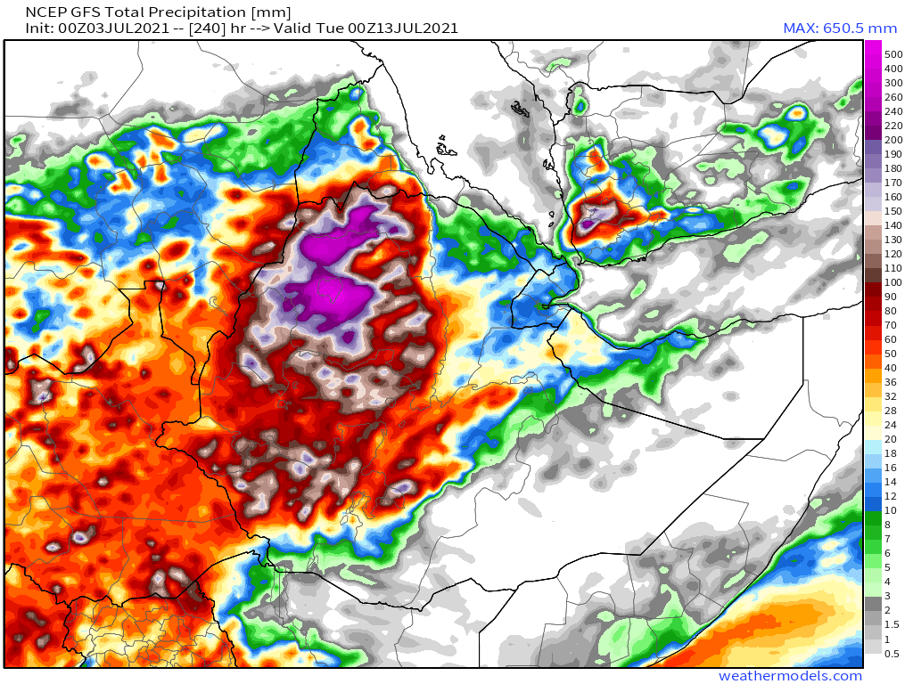
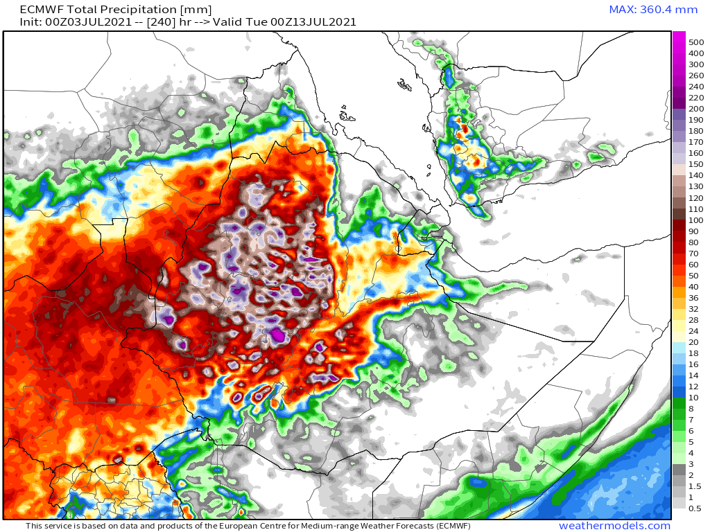
Today's July 3rd 10-day rainfall forecasts for #Ethiopia and the #HornOfAfrica including #Somalia, #Somaliland, eastern parts of #SouthSudan, south eastern parts of Sudan, #Djbouti and #Eritrea. All model forecasts are now both strong and stable. [KMA forecast is for 225 hrs.]
48 Hour forecasts (today and tomorrow) from the same three models. The big rainy season is now underway.
The longer-range forecasts now show significant rain over nearly all of #Ethiopia, and heavy rain in war-torn Tigray.
The longer-range forecasts now show significant rain over nearly all of #Ethiopia, and heavy rain in war-torn Tigray.


This is a corresponding set of PWAT forecasts (5 days apart, GFS model) this time for the Middle East. And here you can see very clearly the relationship between the incoming monsoon moisture and the Ethiopian highlands. The incoming rain targets them with surgical precision.


One of the big unknowns at this point is what impact this strong East African Monsoon will have over the Arabian Peninsula. Here we see today's #ArabianStorm activity which was presumably bringing some of the the rain we have seen in recent forecasts to southern Yemen.
These plots show how unusual this is. They show PWAT anomaly compared with 30 years data 1981-2010. The first shows how much water there is now. The last two shows how much water is expected to be over the region in 10 and 15 days time.


At the bottom of the plots you can see Ethiopia. And this is not that outside the normal range there. But further north over #Yemen, #SaudiArabia and northern areas of the Arabian Peninsual we see large dark green areas indicating 150% of normal PWAT vs recent climate data.
10-Day July 3rd, accumulated rain forecasts for the #MiddleEast from the GFS, ECMWF, CMC & KMA weather models.
#ArabianStorms
#KSA #Yemen #Oman #Jordan #Sudan #Iran #Syria #GERD #Sudan #DesertRain
الله أعلم
#ArabianStorms
#KSA #Yemen #Oman #Jordan #Sudan #Iran #Syria #GERD #Sudan #DesertRain
الله أعلم


48 Hour July 2nd (today and tomorrow), accumulated rain forecasts for the #MiddleEast from the GFS, ECMWF, CMC & KMA weather models.
#ArabianStorms
#KSA #Yemen #Oman #Jordan #Sudan #Iran #Syria #GERD #Sudan #DesertRain
الله أعلم
#ArabianStorms
#KSA #Yemen #Oman #Jordan #Sudan #Iran #Syria #GERD #Sudan #DesertRain
الله أعلم


As always the final rainfall forecasts are long range July 3rd, 16-day (GFS) and 12-day (KMA) accumulated rainfall forecasts for the Middle East..
الله أعلم
الله أعلم

& a rounded picture of the hemisphere. Zero hour simulation data from the GFS.
1. MLSP (Mean Sea Level Pressure)
2. PWAT (potential rain + energy)
3. 250Hpa (jet stream winds approx 11kms high)
4. Precipitable water PWAT anomaly
[Note the persistent PWAT anomaly over Sudan.]
1. MLSP (Mean Sea Level Pressure)
2. PWAT (potential rain + energy)
3. 250Hpa (jet stream winds approx 11kms high)
4. Precipitable water PWAT anomaly
[Note the persistent PWAT anomaly over Sudan.]


And conclude, this animation shows a 16 day simulation of the entire north-western Hemisphere. The PWAT images how the flows of aerial water which is perhaps the most important phenomena in relation to the unusual weather we have been seeing lately pretty much everywhere.
Disclaimer: While simulation models of the physics of the atmosphere can provide us with insights into the dynamics at play here, due to the complexity and degree of variation from historical patterns, at present forecast precision is not great over more than 4 days.
The best examplar of unpredictable weather phenomena is hurricanes. Formation requires a large number of elements to come together. Timing is random, path and intensity are uncertain from hour to hour.
Consider #Elsa, 2021's 1st Atlantic hurricane.
Consider #Elsa, 2021's 1st Atlantic hurricane.
https://twitter.com/althecat/status/1411281874786336768?s=20
#Elsa was given just a 10% chance of formation three days ago. She strengthened yesterday, weakened today. If she sticks to her current course she will bring massive rain to the U.S. if not she might carry her massive load of water to Europe faster.
And if we consider where this forecast bulletin began, back in Ethiopia with the #GERD and the monsoon, what happens in the next 10 days in the Arabian Sea and the Horn will influence hurricane formation a few days later off the Ivory Coast.
/ENDS
@ThreadReaderApp unroll
/ENDS
@ThreadReaderApp unroll
• • •
Missing some Tweet in this thread? You can try to
force a refresh


