
On day 2 of official #GERD filling we have glimpse through the clouds and what looks like a nearly full GERD lake in a recent photograph taken after the spillways were commissioned this year.
Today's #NorthAfrica #HornOfAfrica and #MiddleEast rainfall forecasts follow.
Today's #NorthAfrica #HornOfAfrica and #MiddleEast rainfall forecasts follow.


This morning's rainfall update thread is attached here.
The thread also looks at a major #DesertRain event to the west of the Horn, over Sudan, Chad and Niger where August/September like rains appear to have come early.
The thread also looks at a major #DesertRain event to the west of the Horn, over Sudan, Chad and Niger where August/September like rains appear to have come early.
https://twitter.com/althecat/status/1412701866018938880?s=20
Here's an update from this afternoon with satellite estimated rainfall over the last 24 hours showing 14-35mms of rain over the #Abbay basin.
Here's the @NASA Modis satellite image from this morning (which contained the glimpse of the #GERD in the OP). To the west of the Horn there is a very large and growing area of rainfall which is about to get stronger.
https://twitter.com/althecat/status/1412716112509292546?s=20

Today's big picture contains all the usual elements. Black Sea low. West European storms and of course the Indian and West African Monsoons and the latest daily #ArabianStorms.

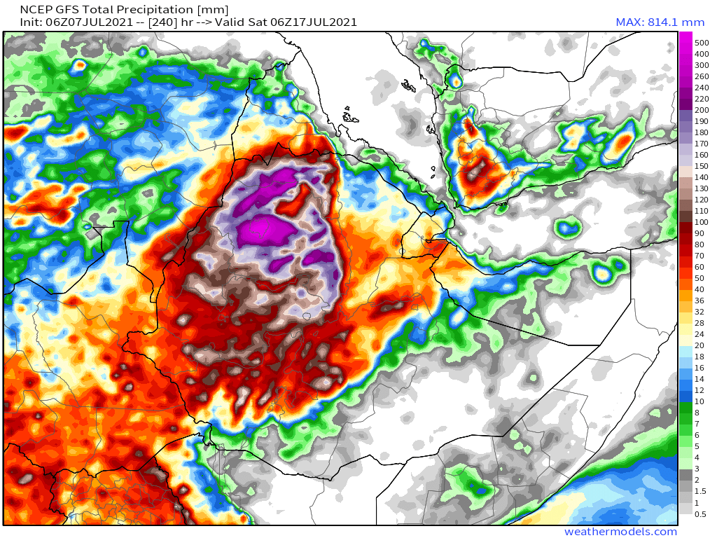
Today's 10-Day Rainfall forecasts for North Africa from July 7th through July 18th.
All models are now forecasting widespread rainfall over #Yemen towards the end of the forecast period. Note also the rainfall in the Sahel. The CMC model may be a over playing this a bit though.
All models are now forecasting widespread rainfall over #Yemen towards the end of the forecast period. Note also the rainfall in the Sahel. The CMC model may be a over playing this a bit though.


Here's a live satellite detected precipitation map showing current storms across the region.

48-hour rainfall forecasts (today and tomorrow from the same four models: the Euro @ECMWF, U.S. @NOAA's GFS, Canada's CMC and the Korean KMA models.


And finally for #NorthAfrica we have the long-range 16-day (GFS) and 12-day (KMA) forecasts - which remain remarkably well aligned.


Here we see a nearly live image of today's intense storms over the #Abbay.

This zoomed out perspective shows the winds bringing the rain from the storms over India on the right hand side and their consequences, the strengthening monsoon over East and Central Africa and #ArabianStorms

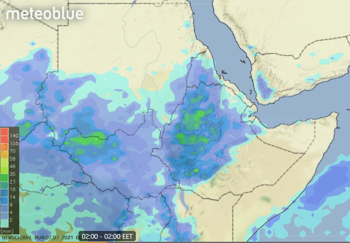
Today's July 7th 10-day rainfall forecasts for #Ethiopia (+1 12-day from KMA) and the #HornOfAfrica including #Somalia, #Somaliland, eastern parts of #SouthSudan, south eastern parts of Sudan, #Djbouti and #Eritrea.
Two of the three models are now forecasting rain for Somalia.
Two of the three models are now forecasting rain for Somalia.


48 Hour forecasts (today and tomorrow) from the same three models. Over this period significant rainfall is not yet forecast for #Somaliland, but it does appear to be coming soon. #Tigray and #Eritrea continue to have rain though, modest amounts in the former.


Today's #ArabianStorms are interesting in their configuration, the rain band that forms over Yemen extending north west into Saudi Arabia in particular.
As sunset approached the #ArabianStorms in the middle of the Arabian Peninsula grew stronger. The second image is from half an hour after the first one. #DesertRain


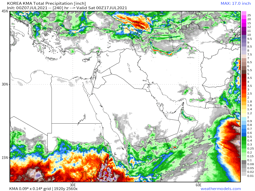
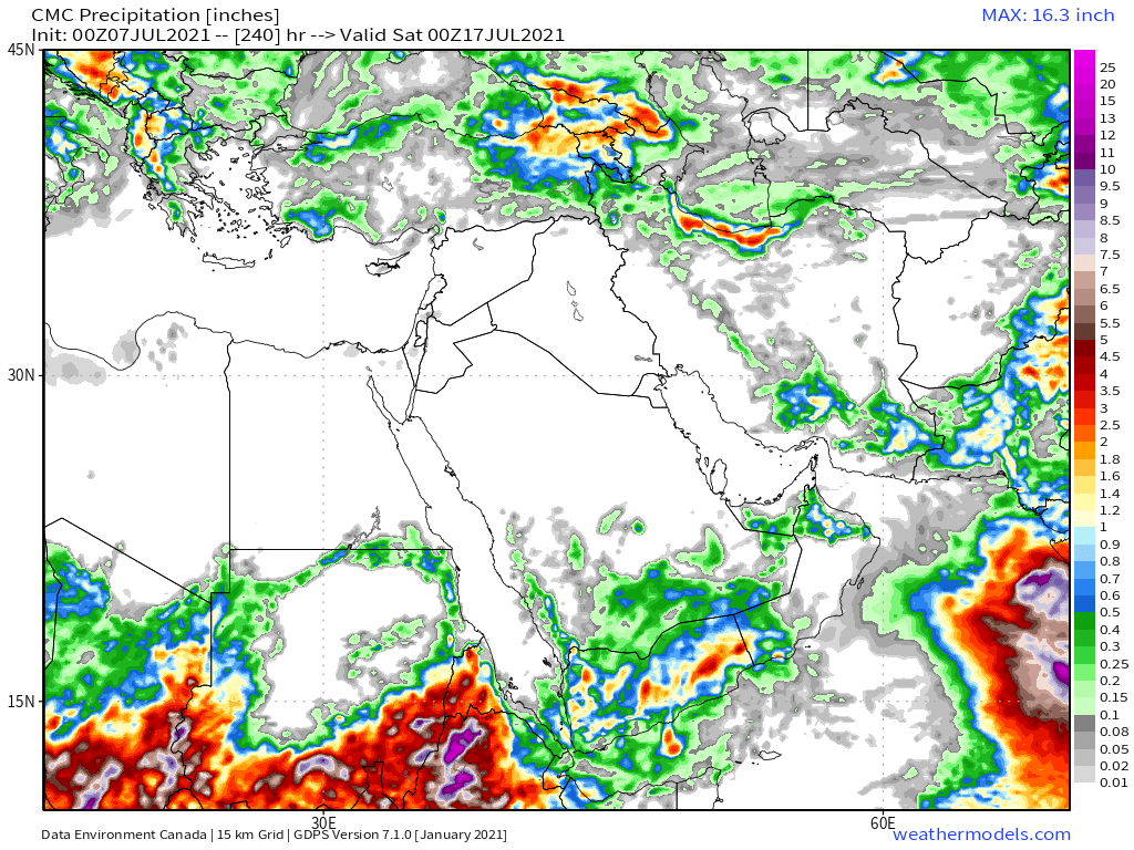
The 10-Day accumulated rain forecasts for the #MiddleEast from the GFS, CMC, KMA & ACG weather models are showing increasingly more #DesertRain in #Yemen and #Oman.
#ArabianStorms
#KSA #Yemen #Oman #Jordan #Sudan #Iran #Syria #GERD #Sudan #DesertRain
الله أعلم
#ArabianStorms
#KSA #Yemen #Oman #Jordan #Sudan #Iran #Syria #GERD #Sudan #DesertRain
الله أعلم

48 Hour July 7th (today and tomorrow), accumulated rain forecasts for the #MiddleEast from the GFS, CMC, KMA and ACG weather models.
#ArabianStorms
#KSA #Yemen #Oman #Jordan #Sudan #Iran #Syria #GERD #Sudan #DesertRain
الله أعلم
#ArabianStorms
#KSA #Yemen #Oman #Jordan #Sudan #Iran #Syria #GERD #Sudan #DesertRain
الله أعلم


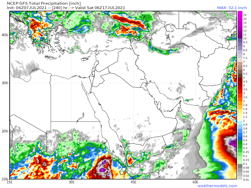
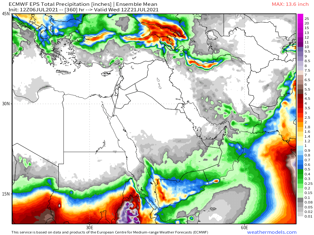
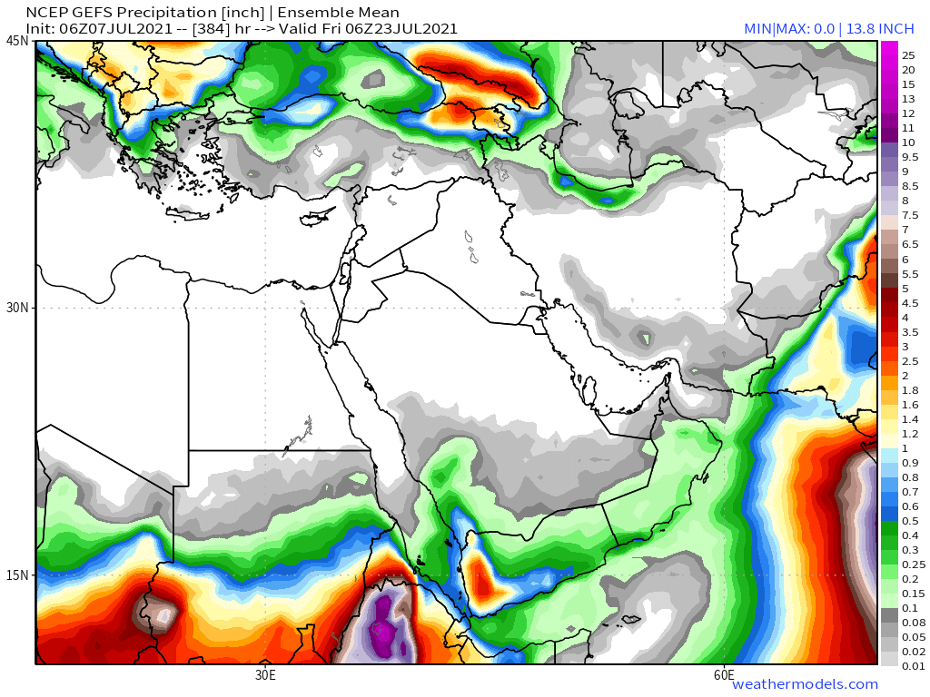
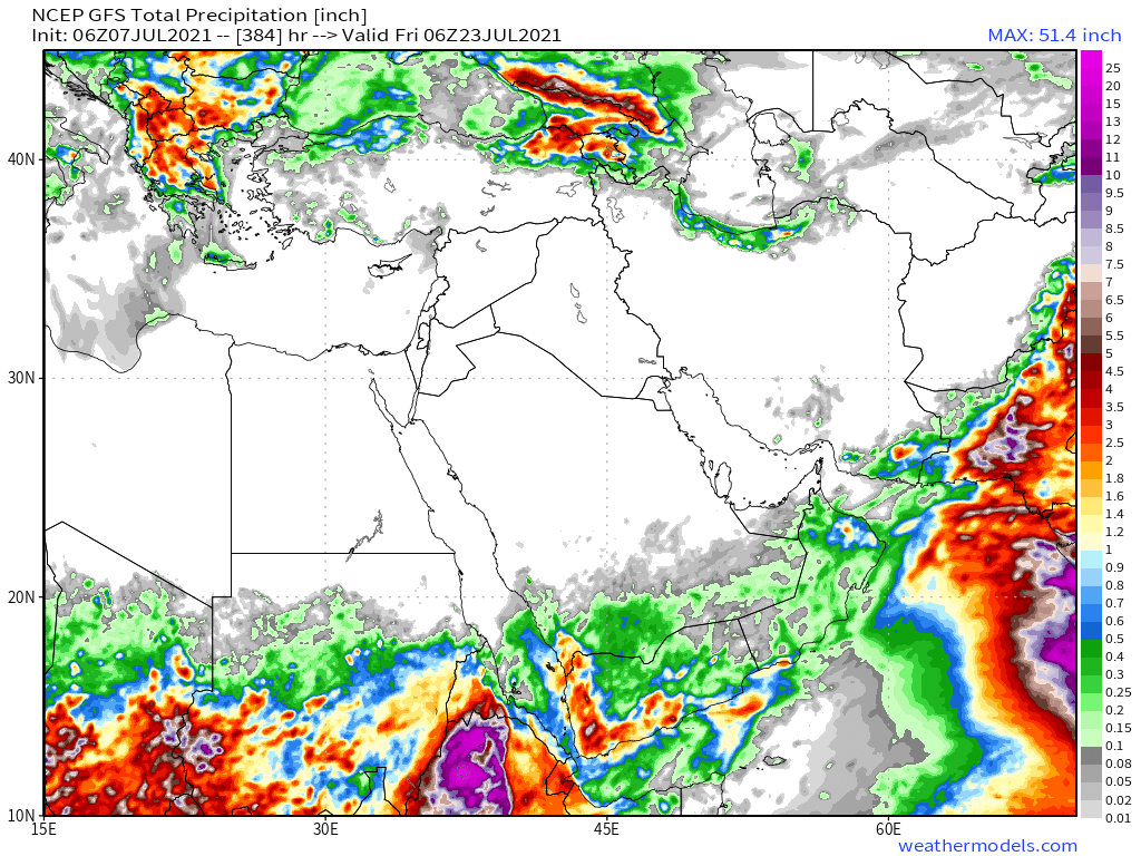
The rainfall forecasts are long-range July 7th rainfall forecasts. The16-day GFS & GEFS models, the 12 day KMA and the 15 day EPS (Euro ensemble) model forecasts for the #MiddleEast.
All now show #DesertRain in #Yemen #Oman and Southern #SaudiArabia
الله أعلم
All now show #DesertRain in #Yemen #Oman and Southern #SaudiArabia
الله أعلم

Our daily rounded picture of the full North Western Hemisphere. Zero hour simulation data from the GFS.
1. Precipitable water PWAT anomaly
2. 250Hpa (jet stream winds approx 11kms high)
3. MLSP (Mean Sea Level Pressure)
4. PWAT (potential rain + energy)
1. Precipitable water PWAT anomaly
2. 250Hpa (jet stream winds approx 11kms high)
3. MLSP (Mean Sea Level Pressure)
4. PWAT (potential rain + energy)


/ENDS
@Threadreaderapp unroll
@Threadreaderapp unroll
• • •
Missing some Tweet in this thread? You can try to
force a refresh


