Thread:
Official report - Recent Developments with #Agung Activities (1 December 2017 21:00 WITA) via @id_magma
(Translated using Google, clarified/edited by me): magma.vsi.esdm.go.id/press/view.php…
Official report - Recent Developments with #Agung Activities (1 December 2017 21:00 WITA) via @id_magma
(Translated using Google, clarified/edited by me): magma.vsi.esdm.go.id/press/view.php…
1/n * Monitoring Data Analysis *
-Visual-
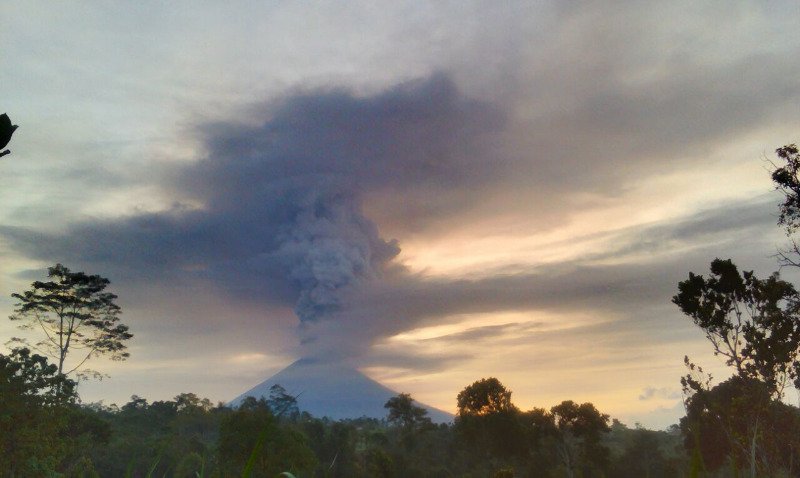
After undergoing a volcanic earthquake swarm over the period Sept-Oct 2017, finally on 21 November 2017 at 17:05 WITA the phase of eruption of Mount Agung evolved to produce volcanic ash as high as 700 m above the peak.
-Visual-
After undergoing a volcanic earthquake swarm over the period Sept-Oct 2017, finally on 21 November 2017 at 17:05 WITA the phase of eruption of Mount Agung evolved to produce volcanic ash as high as 700 m above the peak.
2/n After the eruption, the next eruption occurred again on November 25, 2017 at 17:20 WITA with an ash plume height of 1500 m above the peak. On 26 and 27 November 2017 eruptions occurred with the ash column height reaching 3000 m above the peak.
3/n On 28 November 2017 the eruption produced an ash column reaching 4000 m above the peak. On November 29, 2017 the eruption produced an ash column height reaching 2000 m above the peak.
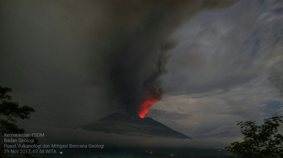
4/n At night, incl. tonight, there is incandescence that emanates from the crater. The observation of the incandescence above the crater is possible due to the presence of high-temperature lava in the crater. This is reflected in the ash/steam plumes causing it to be observed.
5/n Lahars have occurred & mainly flowed in the rivers in the Sthrn sector, incl. Tukad Yehsa, Tukad Sabuh & Tukad Beliaung & in the Nthrn sector in Tukad Bara. The lahars did not result in casualties, however, lahars have impacted several houses, roads and rice fields.
6/n
- Seismicity -
Earthquakes are still dominated by the occurrence of deep and shallow volcanic earthquakes. This indicates that there is still magma movement at depth. Currently the number of volcanic earthquakes is no longer as much as the period September-October 2017.
- Seismicity -
Earthquakes are still dominated by the occurrence of deep and shallow volcanic earthquakes. This indicates that there is still magma movement at depth. Currently the number of volcanic earthquakes is no longer as much as the period September-October 2017.
7/n This happens because the magma path to the surface is now more open. Therefore, although the number is not much, but it does not mean that volcanic activity has subsided.
8/n Continuous tremors with amplitudes over the background level, until overscale (beyond the capability of recording devices) continue to be recorded since November 28, 2017 to today (December 1, 2017). This indicates a high intensity of activity near the surface.
9/n Low-frequency earthquakes are recorded several times and this is related to the movement of Magmatic fluid to the surface.
10/n - Deformation -
GPS measurement results do not record a clear pattern of inflation ahead of the eruption. This is different from the pattern shown by GPS prior to the occurrence of swarms (sequence of volcanic earthquakes) in the period September-October 2017...
GPS measurement results do not record a clear pattern of inflation ahead of the eruption. This is different from the pattern shown by GPS prior to the occurrence of swarms (sequence of volcanic earthquakes) in the period September-October 2017...
11/n
... whereas that GPS showed inflation of the body of Mount Agung [slight outward moving of the volcanic flanks] since August 2017 until mid-September 2017.
... whereas that GPS showed inflation of the body of Mount Agung [slight outward moving of the volcanic flanks] since August 2017 until mid-September 2017.
12/n The pattern shown by the tiltmeter measurements is in the form of inflation before eruption and deflation after eruption takes place.
[tiltmeter general info here: earthquake.usgs.gov/monitoring/def…]
[tiltmeter general info here: earthquake.usgs.gov/monitoring/def…]
13/n - Geochemistry -
Lab test results of the volcanic ash produced by the opening eruption on November 21, 2017 show the existence of juvenile content (new magma material). Within the ash, older material from the 1963 eruption was also identified...
Lab test results of the volcanic ash produced by the opening eruption on November 21, 2017 show the existence of juvenile content (new magma material). Within the ash, older material from the 1963 eruption was also identified...
14/n
... Based on the results of this laboratory test, it can be concluded that the first eruption of Gunung Agung was phreatomagmatic. This eruption can occur when the new magma interacts with water in the aquifer system under the crater of Mount Agung.
... Based on the results of this laboratory test, it can be concluded that the first eruption of Gunung Agung was phreatomagmatic. This eruption can occur when the new magma interacts with water in the aquifer system under the crater of Mount Agung.
15/n
Prior to the Nov 21, 2017 eruption, CO2 gas could be measured at high concentrations by the MultiGAS equipment flown by Drone. However, the SO2 gas concentration was not yet measurable. After the Nov 21, 2017 eruption, to this day...
Prior to the Nov 21, 2017 eruption, CO2 gas could be measured at high concentrations by the MultiGAS equipment flown by Drone. However, the SO2 gas concentration was not yet measurable. After the Nov 21, 2017 eruption, to this day...
16/n
... the concentration of SO2 gas is still consistently measured. Higher concentrations of SO2 was observed over the period of 26-27 November 2017, after which, the concentration of SO2 relatively decreased.
... the concentration of SO2 gas is still consistently measured. Higher concentrations of SO2 was observed over the period of 26-27 November 2017, after which, the concentration of SO2 relatively decreased.
17/n - Remote Sensing Satellite -
Satellite data consistently records hotspots [higher heat output] on 27, 28 and 29 November 2017 with temperatures ranging from 286.6-298.8 +/- 6 degrees Celsius, with a maximum power of 97 megawatts.
Satellite data consistently records hotspots [higher heat output] on 27, 28 and 29 November 2017 with temperatures ranging from 286.6-298.8 +/- 6 degrees Celsius, with a maximum power of 97 megawatts.
18/n
Satellite data also indicate that the effusive eruption (lava flow to the surface) is still occurring within the crater.
Satellite data also indicate that the effusive eruption (lava flow to the surface) is still occurring within the crater.
19/n
This effusive eruption has implications for the addition of lava volume in the crater with an estimated current lava volume of about 20 million cubic meters, or one third of the total volume of the crater.
This effusive eruption has implications for the addition of lava volume in the crater with an estimated current lava volume of about 20 million cubic meters, or one third of the total volume of the crater.
20/n * Conclusions*
Based on multi-parameter data analysis, it can be concluded that until now (December 1, 2017) volcanic activity of Agung is still high and still in the phase of eruption.
Based on multi-parameter data analysis, it can be concluded that until now (December 1, 2017) volcanic activity of Agung is still high and still in the phase of eruption.
21/n
Therefore, the status of Agung is still at Level IV (Awas). Communities around Agung and climbers/visitors/travelers are urged to NOT climb Agung and not to engage in any activity within the Danger Zone...
Therefore, the status of Agung is still at Level IV (Awas). Communities around Agung and climbers/visitors/travelers are urged to NOT climb Agung and not to engage in any activity within the Danger Zone...
22/n
... within the area of the Agung crater and in all areas within a radius of 8 km from the Agung crater, plus the sectoral expansion to the North-Northeast and Southeast-South-Southwest out to 10 km from the Crater of Mount Agung.
... within the area of the Agung crater and in all areas within a radius of 8 km from the Agung crater, plus the sectoral expansion to the North-Northeast and Southeast-South-Southwest out to 10 km from the Crater of Mount Agung.
23/n
It is still safe to travel in Bali as long as you do not enter the above Danger Zone.
Ministry of ESDM
Geological Agency of Volcanology and Geological
Hazard Mitigation
-- END--
magma.vsi.esdm.go.id/press/view.php…
It is still safe to travel in Bali as long as you do not enter the above Danger Zone.
Ministry of ESDM
Geological Agency of Volcanology and Geological
Hazard Mitigation
-- END--
magma.vsi.esdm.go.id/press/view.php…