We've had an opportunity to take a look at the land supply report for GTHA + Simcoe County, Barrie & Orillia by @MGP_Plan for @bildgta bildgta.ca/reports What follows are some initial thoughts on key recommendations re: changes to 2017 Growth Plan
@MGP_Plan @bildgta First off, thread will not focus on @NeptisRegions analysis & @MGP_Plan numbers re: land supply because there's no real substantial difference except in whether we chose to focus on gross #s, net outs, residential only or the size of the urban footprint neptis.org/latest/news/wh…
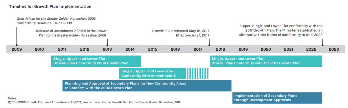
Two of the 6 @bildgta recommendations call for a return to original 2006 Growth Plan Intensification targets & greenfield density targets instead of the ones passed in 2017. Original GP called for 40% of all residential development to be directed to already built-up areas
These are usually areas with existing water & wastewater infrastructure plus some transit. The 2017 GP gradually increases that amount to 50% by 2031 and 60% by 2041.
If you reduce intensification & reduce greenfield densities, then the case for urban expansion onto greenfield beyond the existing greenfield supply already designated by municipalities to accommodate 100,000 people a year to 2031 increases.
Such an expansion would "likely" not be on Greenbelt but on the so-called Whitebelt, a vast swath of about 46,000 hectares of rural & agricultural lands that lie between where settlement exists / planned in GTHA & the greenbelt. Other expansions would leapfrog beyond Greenbelt
Which leads to the third key recommendation of @bildgta which is to formally designate the Whitebelt as a "future urban area" in the Growth Plan making growth on it a given and not a choice, not necessarily today but in time - allowing for infrastructure planning & investment
Other three recommendations by @bildgta focus on more gentle density across the entire built-up area including the Yellow Belt and more enforcement of growth around Major Transit Station Area & Urban Growth Centres.
A return to 2006 Intensification levels (40%), (and this will be discussed separately from greenfield density targets), raises legimitate policy considerations about whether it will help the creation of a compact, connected region & $ billions of dollars in transit investment
To what extent will it let the air of of the balloon in some cities that can / should legitimately intensify - especially given that our and other research has shown population loss in urban centres such as Hamilton, Brampton, Oshawa to name a few.
On the other hand, there is some legitimacy to concerns that the 2017 Greenfield density targets are too high, transitioning from 50 people & jobs per hectares to 80 people & jobs per hectare.
The principal reason is convoluted transition rules that allow low density (50) to be front-ended and the highest densities (80) to be built on designated greenfield that is not yet built, approved, or in an advanced state of planning. Here is how @bildgta depicts it 
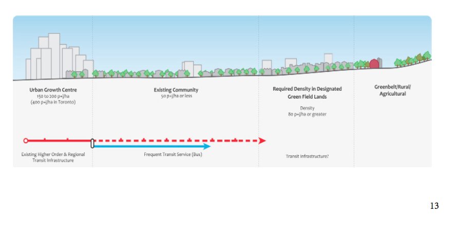
If as @MGP_Plan data shows, most designated greenfield is "committed" or planned w/ orig Growth Plan densities (50) then it follows that a smaller area of land will have to absorb more of the higher densities.
This is an issue for some and not for others. Either way, it has an impact on how much further urban expansion can occur on the whitebelt rural and agricultural lands.
Key thing to keep in mind is that even if land is designated for urban expansion on greenfield, it does not mean it will get built on immediately. @bildgta rightly points out that it takes a long, long time for Greenfield to get built on.
Let's explore why and try to tie some threads together around the theme of unlocking housing supply - as many rightly say is the challenge that must be addressed and why it takes so long, whether it is intensification or greenfield.
First, intensification is difficult because of NIMBYism by residents of already established neighbourhoods who often use antiquated zoning regulations to restrict a mix of much needed supply. Hence all the missing middle, MTSA and yellow belt discussions.
On the greenfield front, you can designate all the land you want as urban, or expand & it does not mean that housing will magically materialize. Big questions remain around the financing of infrastructure, the ability of municipalities to borrow, & who pays for growth
There are also financial & environmental constraints that can sometimes delay greenfield housing - even on land that has already been designated under the Growth Plan.
A case in point of one such challenge is York Region which has been trying to put tens of thousands of homes on greenfield in East Gwillimbury since the late 1980s something that has been constrained by the lack of water & wastewater servicing
We will explore this & other such challenges in this thread in the days to come, while trying to unpack why housing is not being built on land that has already been designated for growth & the big picture re: intensification & greenfield challenges + the case for urban expansion
We are going to pick up on this thread again today in light of @SteveClarkPC announcement today about "Housing Supply Action Plan" as distinct from the "Land Supply" question. While inter-related, and we'll see later why, they need to be understood separately at first.
It can be confusing to some, but as we pointed out last year, such an analysis as the @bildgta report also points out, is relevant primarily to the question of the impact of the new increased greenfield density targets in the 2017 Growth Plan.
It is a subset of the gross amount of greenfield set aside by municipalities for urbanization to accommodate projected growth to 2031. It is only the amt of land that has not been planned. It does not give you a sense of what has not been built on but is available
Note this figure is only for the GTHA & does not include Outer ring municipalities such as Simcoe County, Niagara, Peterborough and more. If you add the designated Greenfield land there. It will be much more. In the tens & thousands of hectares more.
The request by @bildgta to get the Province to designate another 42,200 hectares of Whitebelt land in the GTHA as future urban areas, where as we stated, urban expansion is a given & not a choice needs to be seen in this context - of what has already been designated.
Let's then set aside the Land Supply question for a few minutes and then turn to the to Unlocking Supply Question on land that is available & designated, & try to understand why it's not happening. There are different reasons in different place.
1st e.g. is greenfield. As mentioned earlier York Region has been trying to build homes in East Gwillimbury in its far northern reaches for a while. Some have cited it as a symbol of red tape. A closer look shows that the reasons for unlocking supply there are complex.
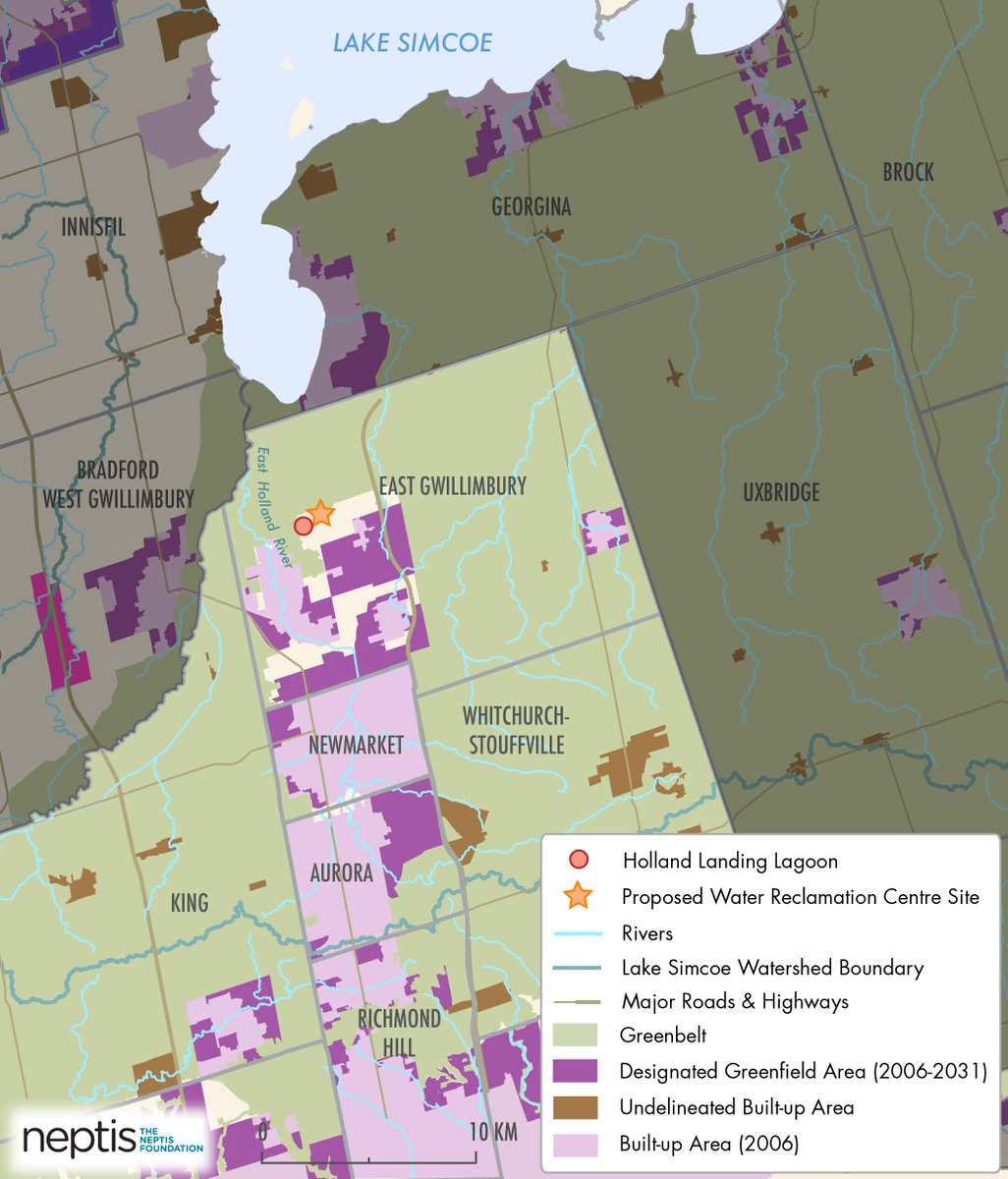
There have been & continue to geographical, environmental & financial challenges to to unlocking supply there, & even if everything were to fall in place, it would be well past 2026 before the $715 million water & wastewater servicing required could be in place.
We'll try to explain what we understand the reason to be, but first we must take a short pause ...
First thing to understand is that attempts to urbanize large scale in East Gwillimbury dates back to the 1980s & the late 1990s! That's when a proposal first emerged to direct growth to enlarge the hamlet of Queensville to a town of 30,000 people & 12,000 jobs.
Today's plans would add another 80,000 residents, mostly to East Gwillimbury but also in nearby Newmarket and Aurora supposedly by 2031. Sewage servicing necessary to service that kind of growth, has, however, been a challenge.
First it's location north of the Oak Ridges Moraine means that the treated sewage would flow north into Lake Simcoe which is under the protection of the Lake Simcoe Protection Plan. The standards of treated water to reduce phosphorus loading into the lake is very costly.
That is why the estimated cost of the first phase of the project is $715 million with the second phase, if expansion were to be allowed in the Whitebelt, raising the cost to almost $1 billion.
Because of the principal that growth must pay for itself, the cost of the UYSS project would require development charges that are collected from developers when housing is built - but the upfront debt for it is either paid by municipal debt or from the municipality's DC reserves
The problem as we understand for York Region is that it was already under a heavy debt burden, the highest in the region, for the York Durham Sewage System that services services Vaughan, Markham & Richmond Hill via a treatment plant in Ajax.
The budgetary challenges for York Region which have delayed the project for years had to do with the fact that for many years especially the period after 2010, housing in Southern York Region - despite the servicing - has not materialized as planned.
This was key reason why York Region, chose to delay the Upper York Sewage Solutions Project. At one point there was $1 billion gap between anticipated DCs & actual collections! York, at one time, anticipated $229 million in water & wastewater dev charges & collected $62 million
The reasons why housing supply is not unlocked easily are complex, but in this case, York Region had spent considerable money to service its southern reaches, but the growth didn't materialize there as anticipated for all kinds of reasons.
Several analysis of census data have re-enforced trends where York Region & Durham Region have not grown at the same levels as say Toronto and Peel.
Finally things get even more complex because even if the money is there to build the Upper York Sewage Solutions. There is the policy question of the cumulative impact of adding between 80,000 to 100,000 residents there on Lake Simcoe phosphorus loading levels.
The CAO of the @LSRCA has noted publicly that collectively more than 9,000 hectares of land has been set for urbanization not just in York Region but Barrie, Innisfil, Bradford West Gwillimbury to name a few that has an impact on the load that Lake Simcoe can bear
The goal of the Lake Simcoe Protection Plan is to reduce the annual phosphorus loading from all sources to 44 tones from the current 72 tonnes. This means very costly measures to reduce harm on the lake even as plans to urbanize increase.
All this to say that this first case study shows that unlocking supply is a complex business with no easy answers. We'll pick up on other complexities in the days ahead.
We forgot to add that one additional complexity on top of those already raised is the question of the the duty to consult with the Chippewas of Georgina Island First Nation who have opposed the UYSS project because of its impact on Lake Simcoe.
This duty to consult has held up approval of the Environmental Assessment that allow the Upper York Sewage Solutions project by the @RodPhillips01 minister of Environment to go ahead. End of thread for now.