
Day three of official #GERD filling today in Ethiopia. And a gap in the clouds this morning reveals the GERD lake on the #Abbay river.
Today's #HornOfAfrica, #NorthAfrica and #MiddleEast rainfall forecasts follow.
Today's #HornOfAfrica, #NorthAfrica and #MiddleEast rainfall forecasts follow.

Here we zoom out a little, the source of the #Abbay/#BlueNile Lake Tana takes pride of place. You can see the #GERD lake in the bottom left hand corner.
These images are from the @NASA Modis Worldview service. Also below a picture of the #GERD from back in January.
These images are from the @NASA Modis Worldview service. Also below a picture of the #GERD from back in January.


Here's today's big picture as ever of the great Sahara Desert. You can see today's #ArabianStorms starting up bottom right, and top left a new rain front coming into Western Europe where the 2021 #EuropeBigWet continues to bring rain and unseasonably mild temperatures.

Today's 10-Day Rainfall forecasts for North Africa from July 2nd through July 11th.
[NOTE: The widespread rainfall in the CMC forecast for Yemen is a new feature and supported in the long-range GFS forecast.]
[NOTE: The widespread rainfall in the CMC forecast for Yemen is a new feature and supported in the long-range GFS forecast.]


48-hour rainfall forecasts (today and tomorrow from the same four models: the Euro @ECMWF, U.S. @NOAA's GFS, Canada's CMC and Korea's KMA models.
In all forecasts short and long range we now see rainfall pushing deep into northern areas in the Sahel.
In all forecasts short and long range we now see rainfall pushing deep into northern areas in the Sahel.


Finally, long-range 16-day (GFS) &12-Day (KMA forecasts for the wider region. I have included a closeup from the long-range GFS forecast. The extent of rainfall in the Western Sahara now shown by the GFS is similar to that in the much more #desertrain bullish CMC and KMA models


Here's a six hour animation of rain building today over Ethiopia running from 9.30am GMT. Its not quite as strong as the past two days but these storms tend to build until evening and then continue deep into the night.
Here we see the source of the water which is powering the East Africa Monsoon rains, streams of airborn moisture caused by convective storms over the Arabian Sea, India, the Bay of Bengal and South East Asia.
This forecast map shows the high altitude winds which guide these aerial water flows. The coloured areas show faster wind speeds.

Today's July 2nd 10-day rainfall forecasts (+1 12 day forecast from KMA) for #Ethiopia and the #HornOfAfrica including #Somalia, #Somaliland, eastern parts of #SouthSudan, south eastern parts of Sudan, #Djbouti and #Eritrea. All model forecasts are now both strong and stable.


48 Hour forecasts (today and tomorrow) from the same three models. The big rainy season is now underway.
The longer-range forecasts now show significant rain over nearly all of #Ethiopia, and heavy rain in war-torn Tigray.
The longer-range forecasts now show significant rain over nearly all of #Ethiopia, and heavy rain in war-torn Tigray.


Today's #ArabianStorms coming to life in Yemen, Oman and Saudi Arabia.
10-Day July 2nd, accumulated rain forecasts for the #MiddleEast from the GFS, ECMWF, CMC & KMA weather models.
#ArabianStorms
#KSA #Yemen #Oman #Jordan #Sudan #Iran #Syria #GERD #Sudan #DesertRain
الله أعلم
#ArabianStorms
#KSA #Yemen #Oman #Jordan #Sudan #Iran #Syria #GERD #Sudan #DesertRain
الله أعلم


48 Hour July 2nd (today and tomorrow), accumulated rain forecasts for the #MiddleEast from the GFS, ACG, CMC & KMA weather models.
#ArabianStorms
#KSA #Yemen #Oman #Jordan #Sudan #Iran #Syria #GERD #Sudan #DesertRain
الله أعلم
#ArabianStorms
#KSA #Yemen #Oman #Jordan #Sudan #Iran #Syria #GERD #Sudan #DesertRain
الله أعلم


As always the final rainfall forecasts are long range July 1st, 16-day (GFS) and 12-day (KMA) accumulated rainfall forecasts for the Middle East.
This level of rainfall in Yemen is a first for the GFS model so far in the 2021 spring-summer.
الله أعلم
This level of rainfall in Yemen is a first for the GFS model so far in the 2021 spring-summer.
الله أعلم


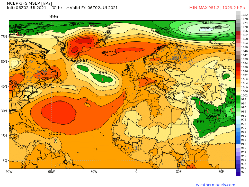
& a rounded picture of the hemisphere. Zero hour simulation data from the GFS.
1. Precipitable water PWAT anomaly
2. PWAT (potential rain + energy)
3. MLSP (Mean Sea Level Pressure)
4. 250Hpa (jet stream winds approx 11kms high)
[Note the persistent PWAT anomaly over Sudan.]
1. Precipitable water PWAT anomaly
2. PWAT (potential rain + energy)
3. MLSP (Mean Sea Level Pressure)
4. 250Hpa (jet stream winds approx 11kms high)
[Note the persistent PWAT anomaly over Sudan.]


...Threadfix ..
https://twitter.com/althecat/status/1410967304452640772?s=20
/ENDS
@Threadreaderapp unroll
@Threadreaderapp unroll
• • •
Missing some Tweet in this thread? You can try to
force a refresh


