THREAD. Here’s the story of the reconstruction of the layout of a small #medieval town in 1249-5 - including who was living where: #CanYouBelieveIt? It’s March, in fenland like many of my examples, but the methods are straightforward & can be applied anywhere. 
2. Altho the one I’m interested in (around the crossing of the R Nene) is called March today, it was called Mercheford in 1249-50 when it was 1st recorded. The 13thC place called March lay about a mile to the S around the church near the bottom of the OS map.


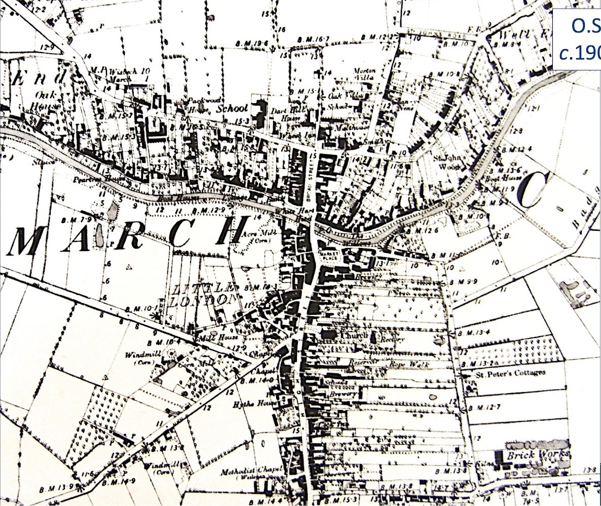
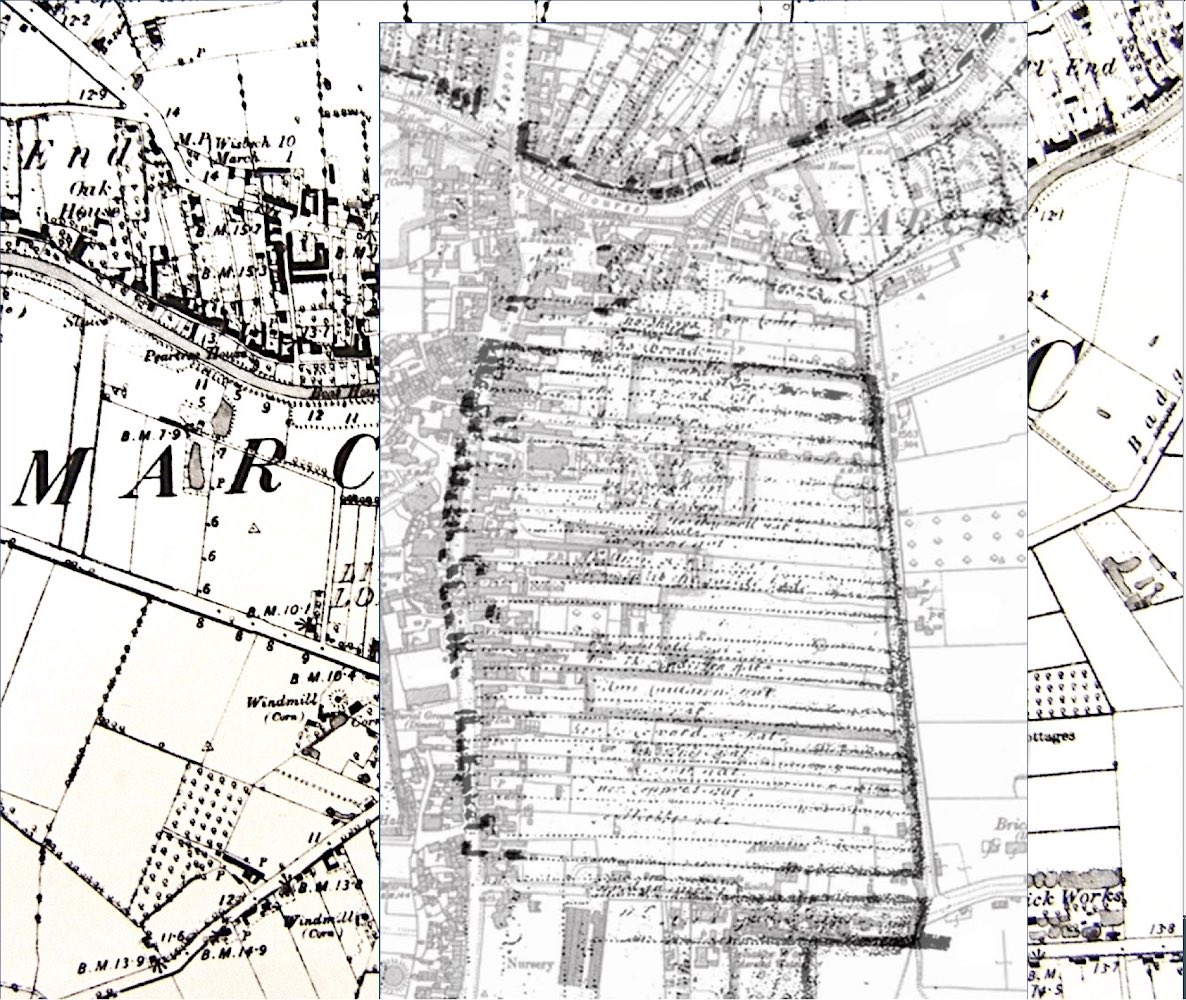
3. Here’s the 1900 OS map of Mercheford. It’s believed to have been a planned settlement, laid out between 1222 (when it wasn’t mentioned in a list of the Bp of a Ely’s estates) & 1249-50 (when it was). Was it planned? How can we tell? The rule is..

4. .. where blocks of properties (a) share the same front & back boundaries and (b) are of the same/multiples of/subdivisions of a standard width, then that’s evidence of planning. And here you can see those blocks S of the river, & along its N bank...
5. So, if that was true in 1900, was it also true before then? Best check against available maps 👀👀👀👀 one of 1841, another of c1601-3, & a 16thC copy of a late (maybe c1500?) medieval map. And hurrah! the later medieval plan was certainly the same as it was in 1900...


6. That leaves 3 questions: (1) How reliable are the maps, (2) was it really planned or is the regularity just one of those things? And if it was (3) when?
So, (1) How reliable are the maps? The OS & tithe maps were professionally surveyed, so I think we can rely on them.
So, (1) How reliable are the maps? The OS & tithe maps were professionally surveyed, so I think we can rely on them.


7. The 1601-3 map can be tested by overlaying it on the 1900 map - and it matches perfectly, even to the individual property boundaries. The late medieval map is indicative - it suggests the same T-shaped plan but we can’t be sure.

8. Were the properties of a standard area? They were accurately measured in 1841 and it was so exciting to find that those on the N bank of the river were all around 3 roods 3 perches - & their multiples subdivided well too - while those to the S were each 1 acre 1 rood in area.


9. So: definitely planned! But when? I found the answer in the records of the manors belonging to the Bishop of Ely in 1249-50 - and, most importantly, their tenants.
[NOTE btw: 40 perches = 1 rood
4 roods = 1acre]
[NOTE btw: 40 perches = 1 rood
4 roods = 1acre]

10. At that time there were 90 tenants in Mercheford each holding a messuage (a house with land around it) for which each paid 6d. a year. These were standard holdings - everyone paid the same rent for the same thing, & multiple/fractional holdings paid multiples/fractions of 6d.

11. The list had me stumped for a while. Then one day I realised it was like a code: it listed blocks of standard messages each @ 6d, interspersed by fractional holdings paying fractions of 6d., like this

12. ... and the sequence looked like this. Could it be mapped against the areas in the properly-surveyed tithe map? Yes, it jolly well could! And, although I don’t have room to show you here, the fractional holdings also survived intact. What that meant was...

13. .. that the actual plots where all 90 of the 13thC tenants lived had survived into the 19th (& 21st) C and could be identified. Anyone could walk through parts of March today naming one by one the homes of individuals who lived there nearly 900 years ago.

14. All this and more is explained more slowly in …ofsusanoosthuizen.files.wordpress.com/2020/01/oosthu… should you be interested.
15. So I bet you’re all asking “What is a languetta”, or is that just me? 🤣 well, actually I don’t know beyond it being a strip (tongue [from Fr. langue]) of land, perhaps surrounded by water on 3 sides. They are mentioned only in relation to one block of properties, so

16. .. if they might be the frontages between the properties and the river, perhaps to allow boats to park on private cuts leading off the river. You can see them on the tithe map too.


17. In the end I concluded these could not be the languettae because each of those little frontages is (a) so small & (b) rises so steeply from the river that the cuts wd need to widen in a V & their sides extensively shored up. & there’s no sign of them, so they remain a mystery

18. The key to this is in small steps of logic, one question at a time. The maps are all in public archives, the Coucher Book is published. Similar sources exist in other parts of Britain. So be brave! Go out & conquer! What’s the worst that could happen? It will be fun. 🤗

13a. Meant to say: the evidence indicates that Mercheford was a planned settlement w/ 90 properties laid out by (i.e. for) the Bp of Ely sometime betw 1222 & 1249-50. I don’t think the difference in area betw the blocks N & S of the river is significant as all pay the same rent.