
Let's start a #Serbian & #Yugoslav map thread.
Here I'll share the best material I compiled over 3 years about the #History of #Serbia & #Yugoslavia.
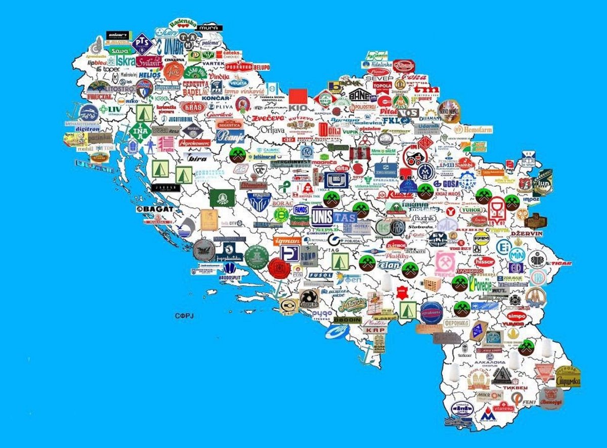
Let's start with a map of companies implanted in SFR.Yugoslavia.🏭
57 are detailed in the link provided.👇
investitor.me/2019/06/17/50-…
Here I'll share the best material I compiled over 3 years about the #History of #Serbia & #Yugoslavia.
Let's start with a map of companies implanted in SFR.Yugoslavia.🏭
57 are detailed in the link provided.👇
investitor.me/2019/06/17/50-…
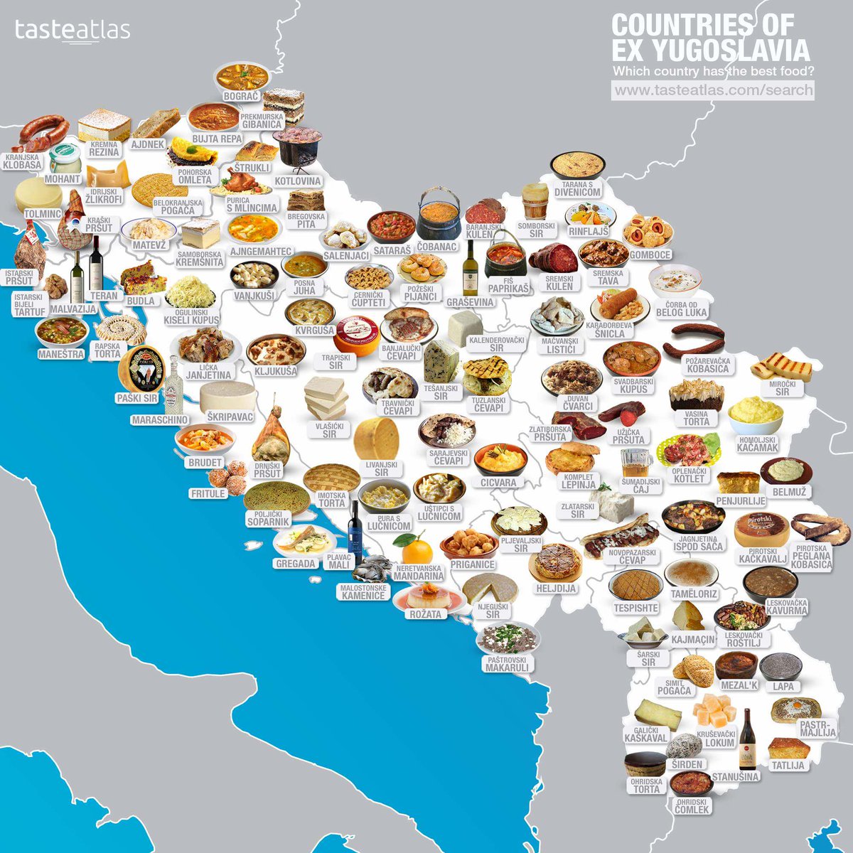
2. Here comes a #Yugoslav map for foodies.
Unlike for companies, the destruction of #Yugoslavia didn't change the local specialties, which remain the delight of all locals & visitors.
#Meatlovers are like fish in water there, & back in #France I dearly miss ćevap & pljeskavica!🥺
Unlike for companies, the destruction of #Yugoslavia didn't change the local specialties, which remain the delight of all locals & visitors.
#Meatlovers are like fish in water there, & back in #France I dearly miss ćevap & pljeskavica!🥺
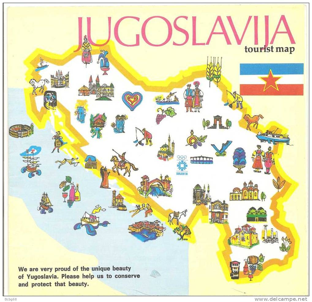
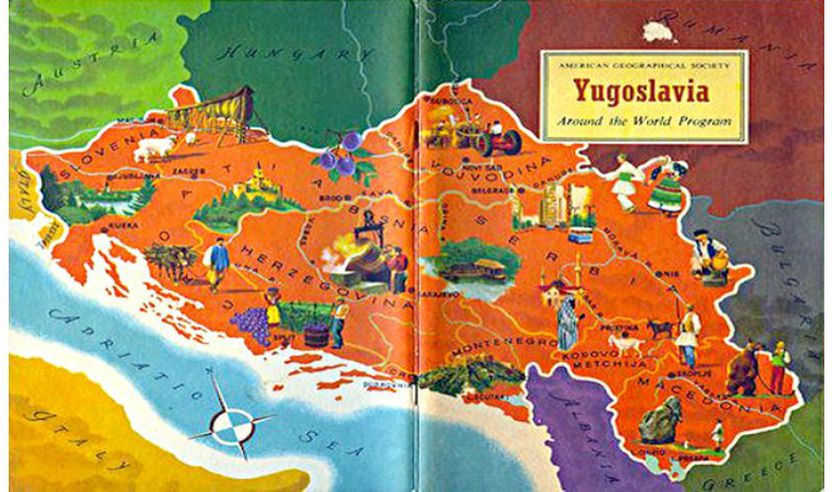
3. Here are 2 pseudo #tourism-maps of #Yugoslavia, respectively made by locals & #Americans.
I wish we helped, as requested, to conserve & protect this #beauty.🕯️
As a citizen of a #NATO country, & especially as a #French, I'm sorry we didn't, even if most of this still exists.🙏
I wish we helped, as requested, to conserve & protect this #beauty.🕯️
As a citizen of a #NATO country, & especially as a #French, I'm sorry we didn't, even if most of this still exists.🙏
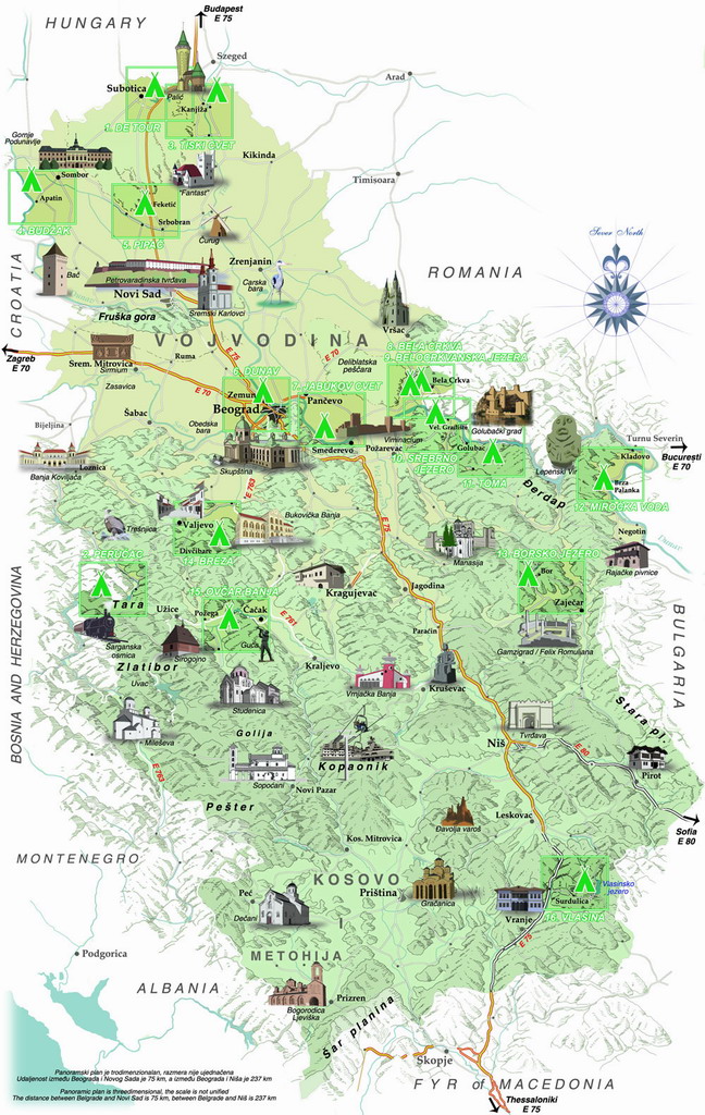
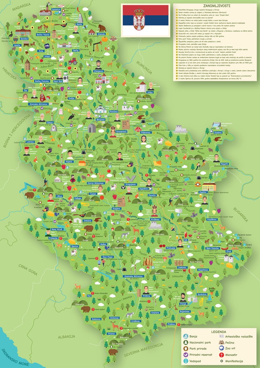
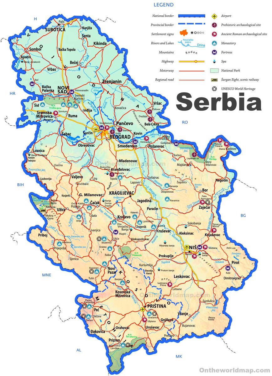
4. Here are 2 maps presenting the #landmarks of #Serbia.
Excluding the current #Covid19 situation, Serbia is more & more attractive for #tourism due to all its Historical places & natural beauty to be rediscovered, after the 3 decades of relative isolation endured by the country.
Excluding the current #Covid19 situation, Serbia is more & more attractive for #tourism due to all its Historical places & natural beauty to be rediscovered, after the 3 decades of relative isolation endured by the country.
5. Here comes a detailed map of the landmarks of #Montenegro (which I now recommend w/o any reserve since the corrupt government of #MiloDjukanovich's #DPS is now out of business).
After the pandemic, #CrnaGora will need all the help & visitors it can get to get back on its feet!
After the pandemic, #CrnaGora will need all the help & visitors it can get to get back on its feet!

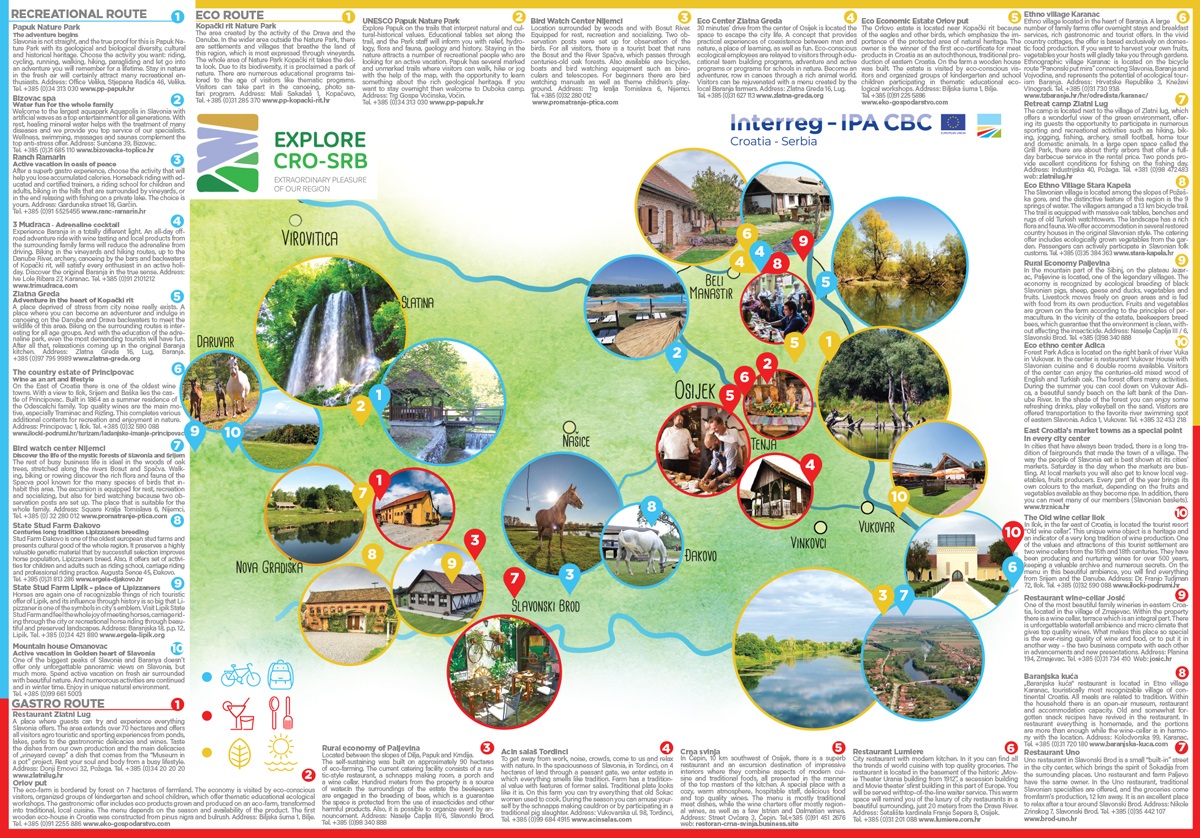
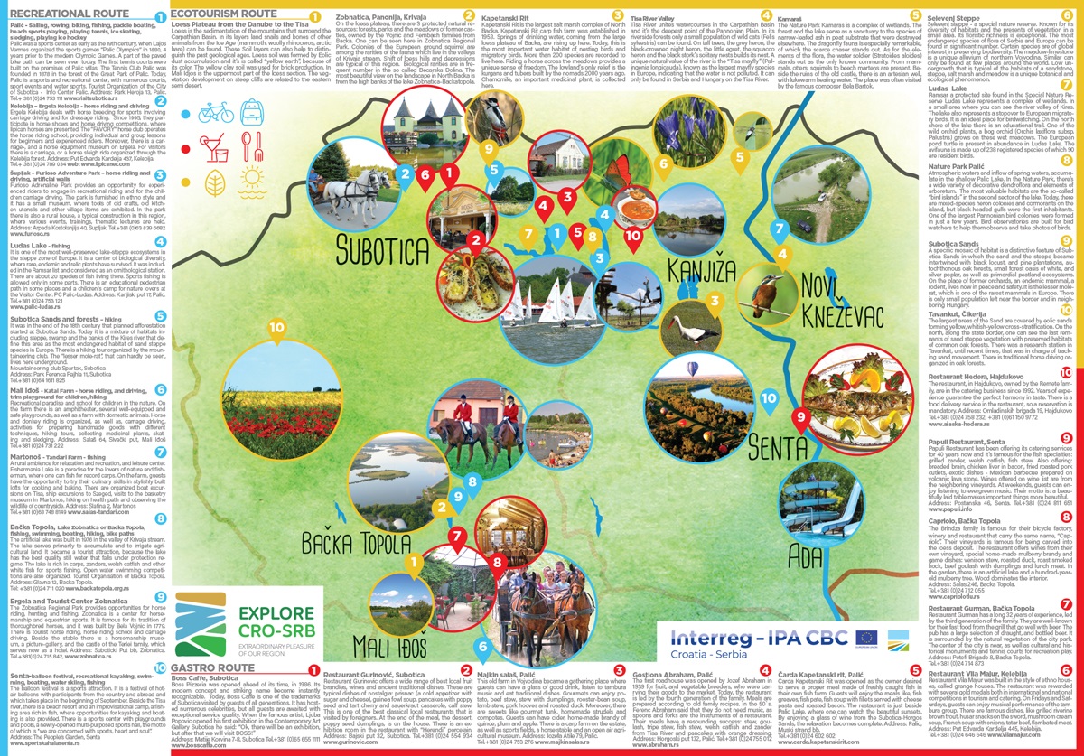
6. Here are 2 nice contextualized #tourism maps of #Slavonia (#Croatia) & #Vojvodina (#Serbia), made in partnership w/ #EuropeanUnion, w/ a presentation of each item mapped.🗺️
The resolution is a bit low for the text in #English, but it remains readable w/ the appropriate zoom.🔍
The resolution is a bit low for the text in #English, but it remains readable w/ the appropriate zoom.🔍
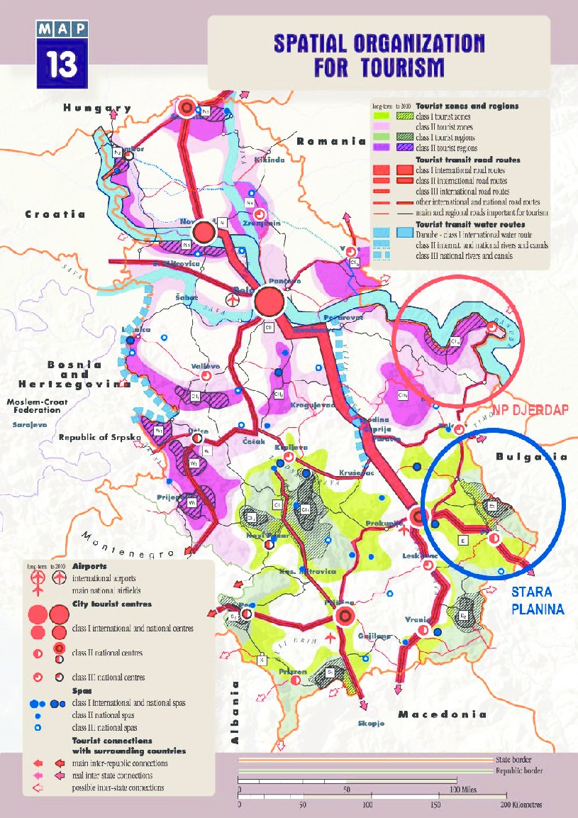
7. Here are 2 maps dedicated to #tourism in #Serbia in a systemic approach.
The 1st is a general map, & the 2nd is a more academic one presenting tourism in terms of zones & transit paths.
I know, the thread is supposed to be about #History, but I chose to start w/ light stuff!🙏
The 1st is a general map, & the 2nd is a more academic one presenting tourism in terms of zones & transit paths.
I know, the thread is supposed to be about #History, but I chose to start w/ light stuff!🙏
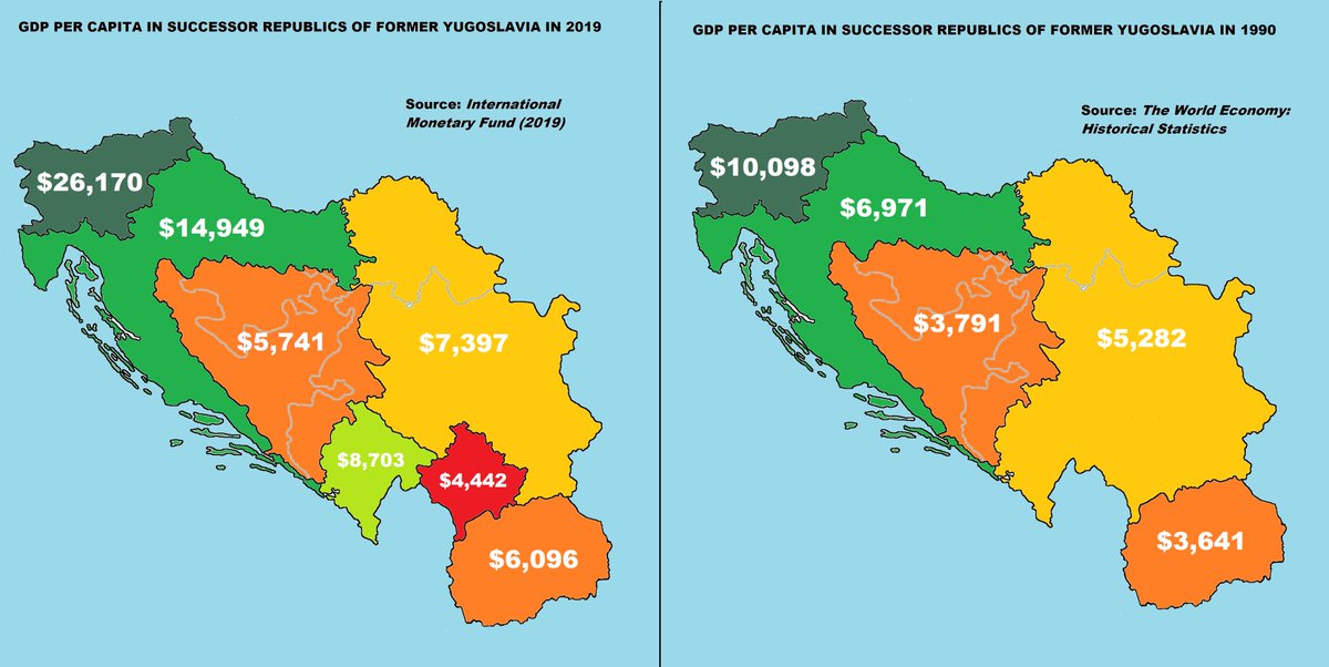
8. Here's a map comparing each ex-#Yugoslavia Republic's GDP in 1990 (#SRJ anachronistically counted) & 2019 (the occupied Serbian province of #Kosovo & #Metohija being counted out of #Serbia).
We can see the 4+1 polities who didn't make a great deal w/ breakup.
As for #Croatia..
We can see the 4+1 polities who didn't make a great deal w/ breakup.
As for #Croatia..
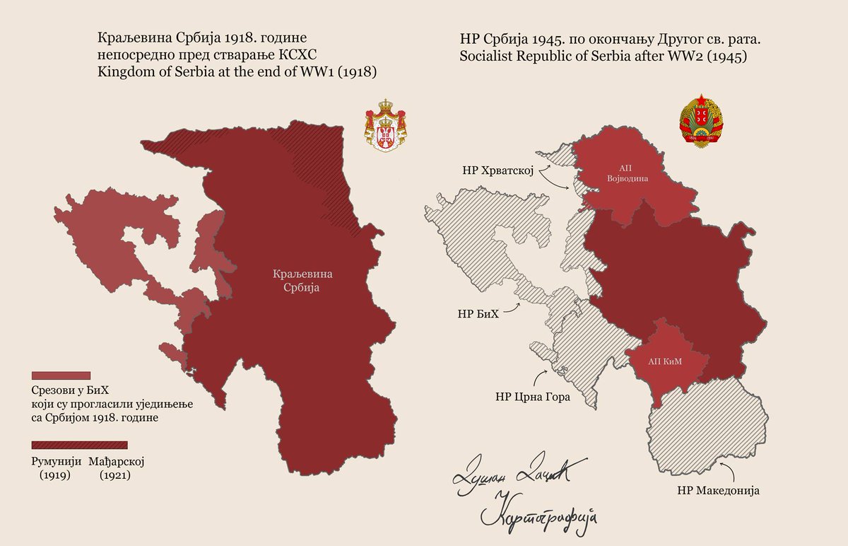
9. Here's a map comparing what #Serbia controlled in 1918, & what was left of it after #Tito & the #AVNOJ decided in 1943-1945 of its borders within #Yugoslavia to be.
Yugoslavia didn't pay off for #Serbs & retrospectively King #Aleksandar #Karadjordjevic picked the wrong option.
Yugoslavia didn't pay off for #Serbs & retrospectively King #Aleksandar #Karadjordjevic picked the wrong option.
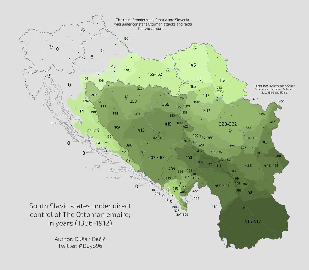
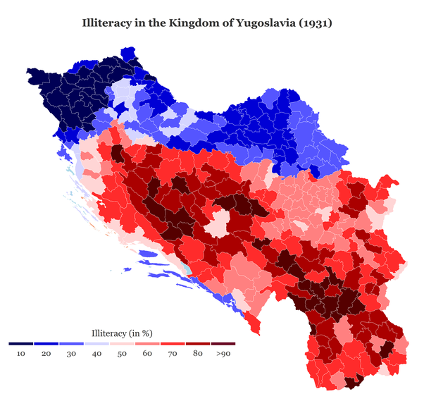
10. Here's a similar map focused on the formation of the Kingdom of SHS/#Yugoslavia to be by the same @Duyo96, accompanied w/ his excellent new map displaying the duration of the #Ottoman occupation in the region & a map of its consequences: the illiteracy in #Yugoslavia in 1931.

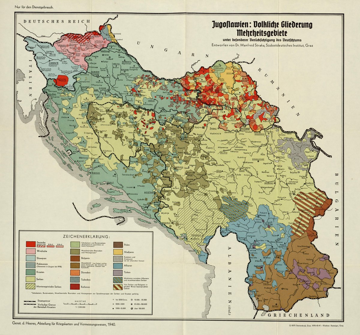
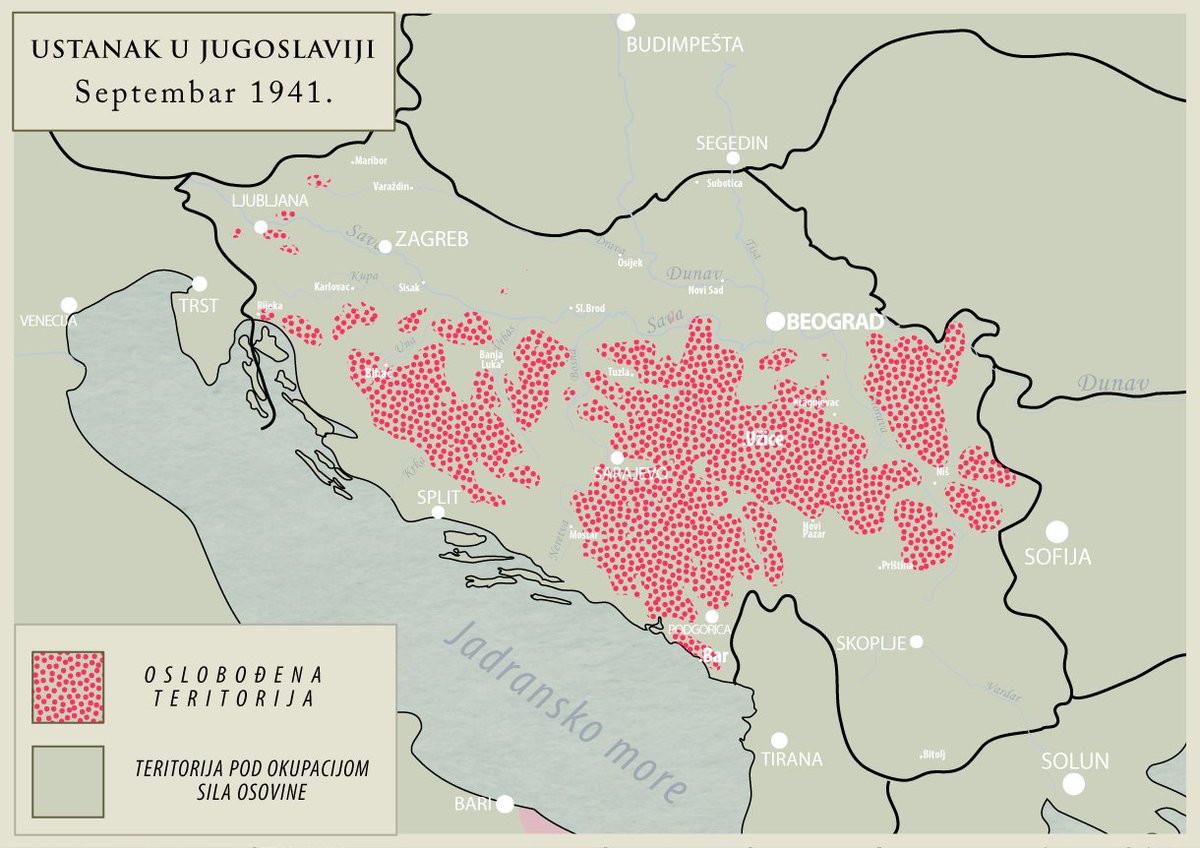
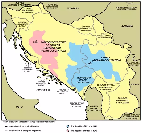
11. Here's a trio of interesting maps to compare.
The 1st shows the ethnic occupation of #Yugoslavia in 1940.
The 2nd & 3rd show the areas which uprose 1st vs the #Axis occupation.
Notice any obvious similarity?
Me too: the insurgent zones are those populated by #Serbs!💪
#Facts!
The 1st shows the ethnic occupation of #Yugoslavia in 1940.
The 2nd & 3rd show the areas which uprose 1st vs the #Axis occupation.
Notice any obvious similarity?
Me too: the insurgent zones are those populated by #Serbs!💪
#Facts!
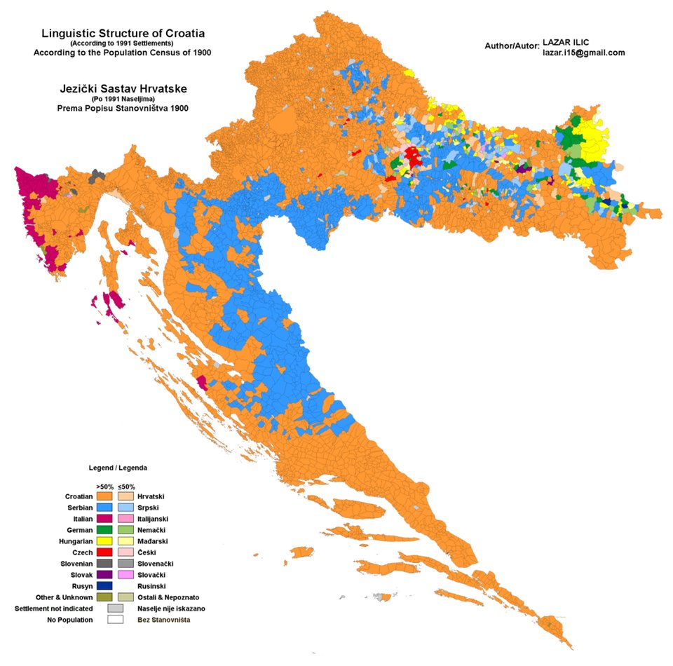
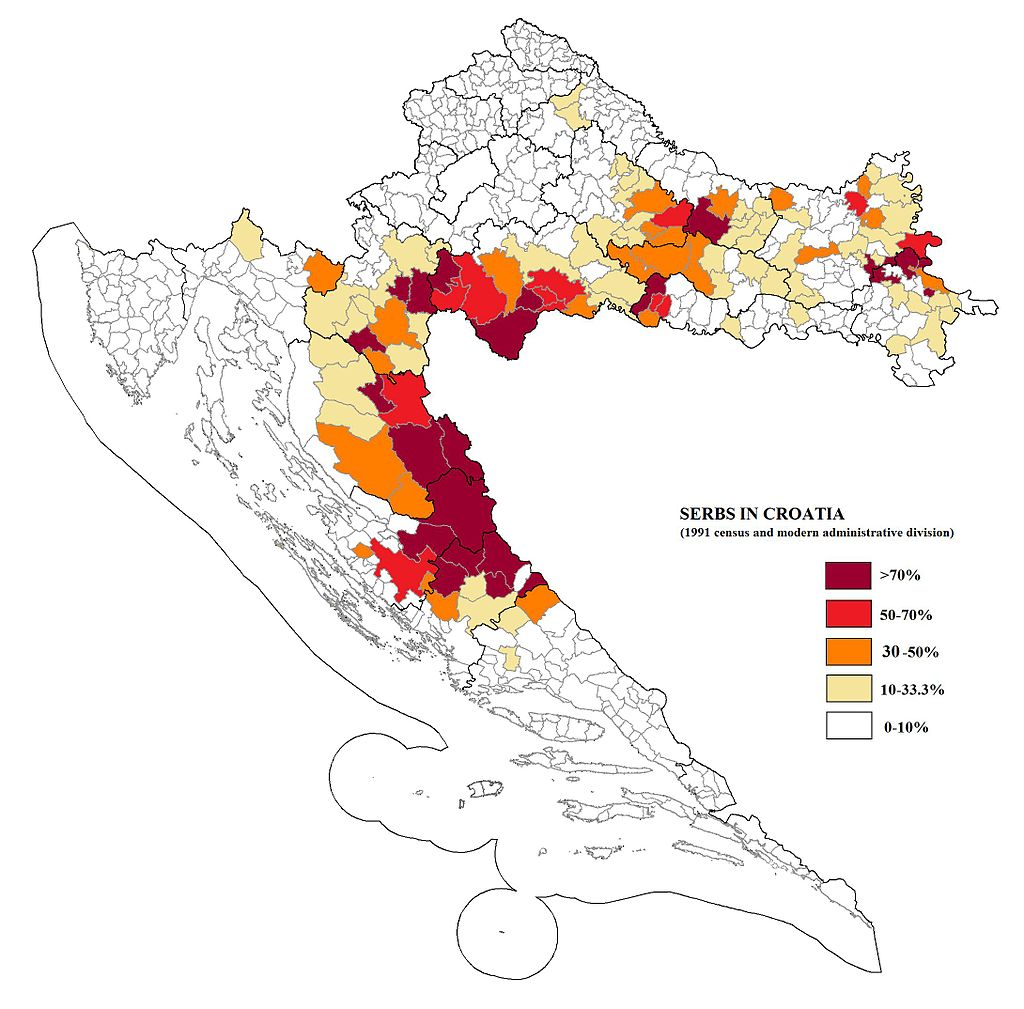
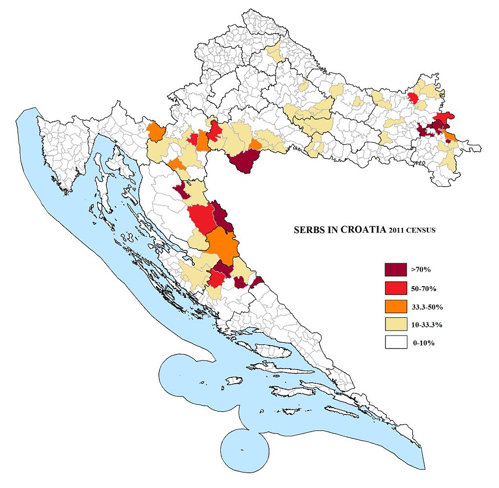
12. Meanwhile, #Croats didn't waste any time during the 20th century.
This map shows the geographic coverage of the #Serbs on the territory which is today contemporary #Croatia.
In 1900, the proportion of Serbs on that territory was 17.3% while Croats were 4x more numerous:68.3%.
This map shows the geographic coverage of the #Serbs on the territory which is today contemporary #Croatia.
In 1900, the proportion of Serbs on that territory was 17.3% while Croats were 4x more numerous:68.3%.
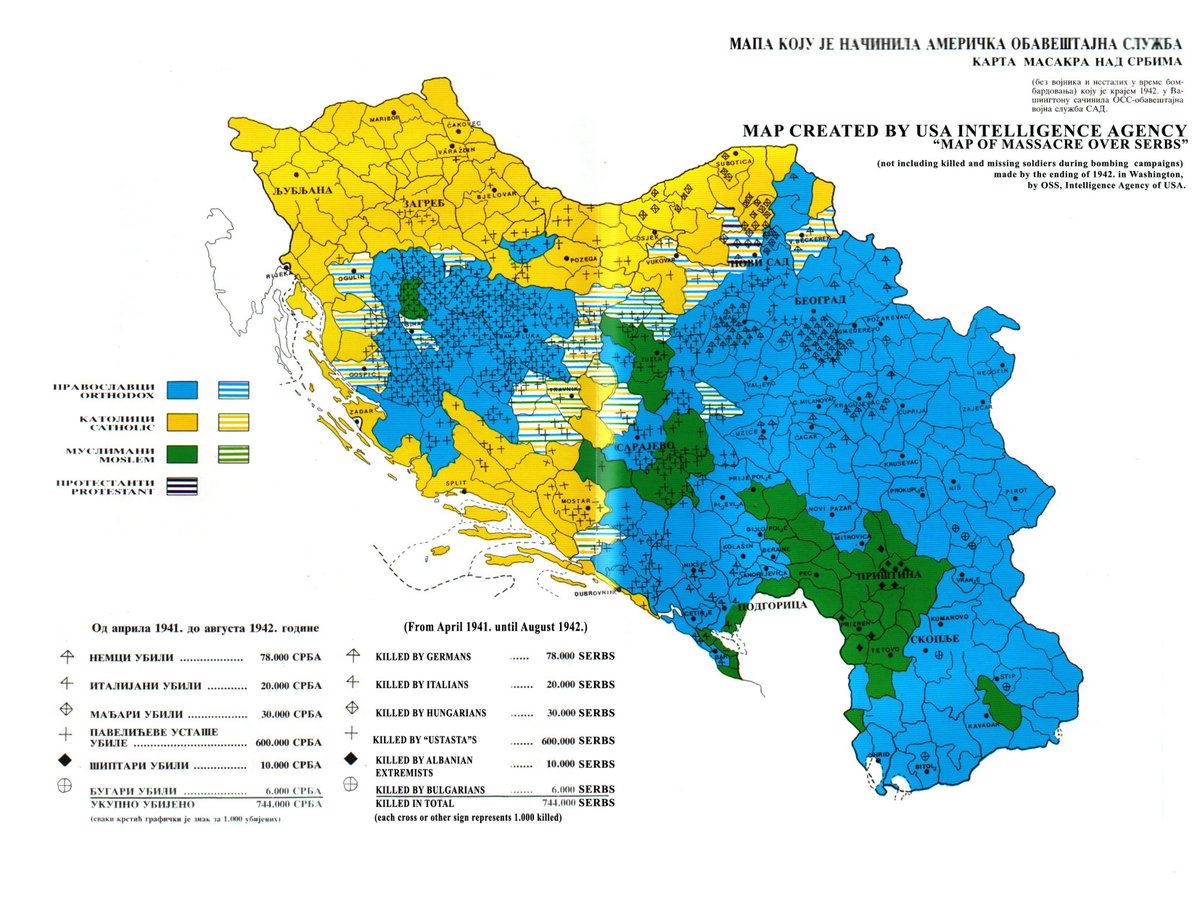
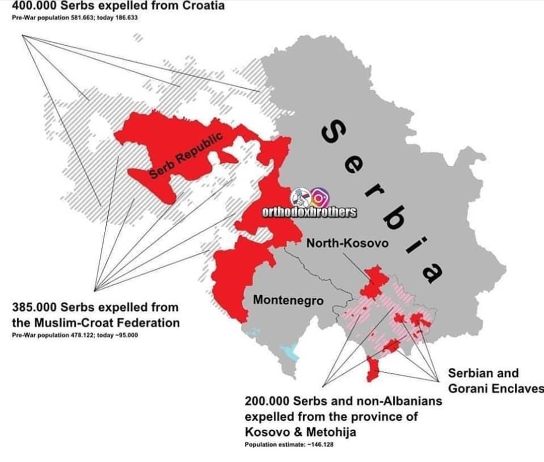
13. During WW2, Croatian #Ustashe exterminated more than 300,000 #Serb civilians in the Nazilike "Independent State of #Croatia" which covered modern day🇭🇷 & #Bosnia & #Herzegovina.
In 1995, even more Serbs to flee or were expelled by🇭🇷🇧🇦forces.
Result: Serbs are 4.5% today in🇭🇷.
In 1995, even more Serbs to flee or were expelled by🇭🇷🇧🇦forces.
Result: Serbs are 4.5% today in🇭🇷.
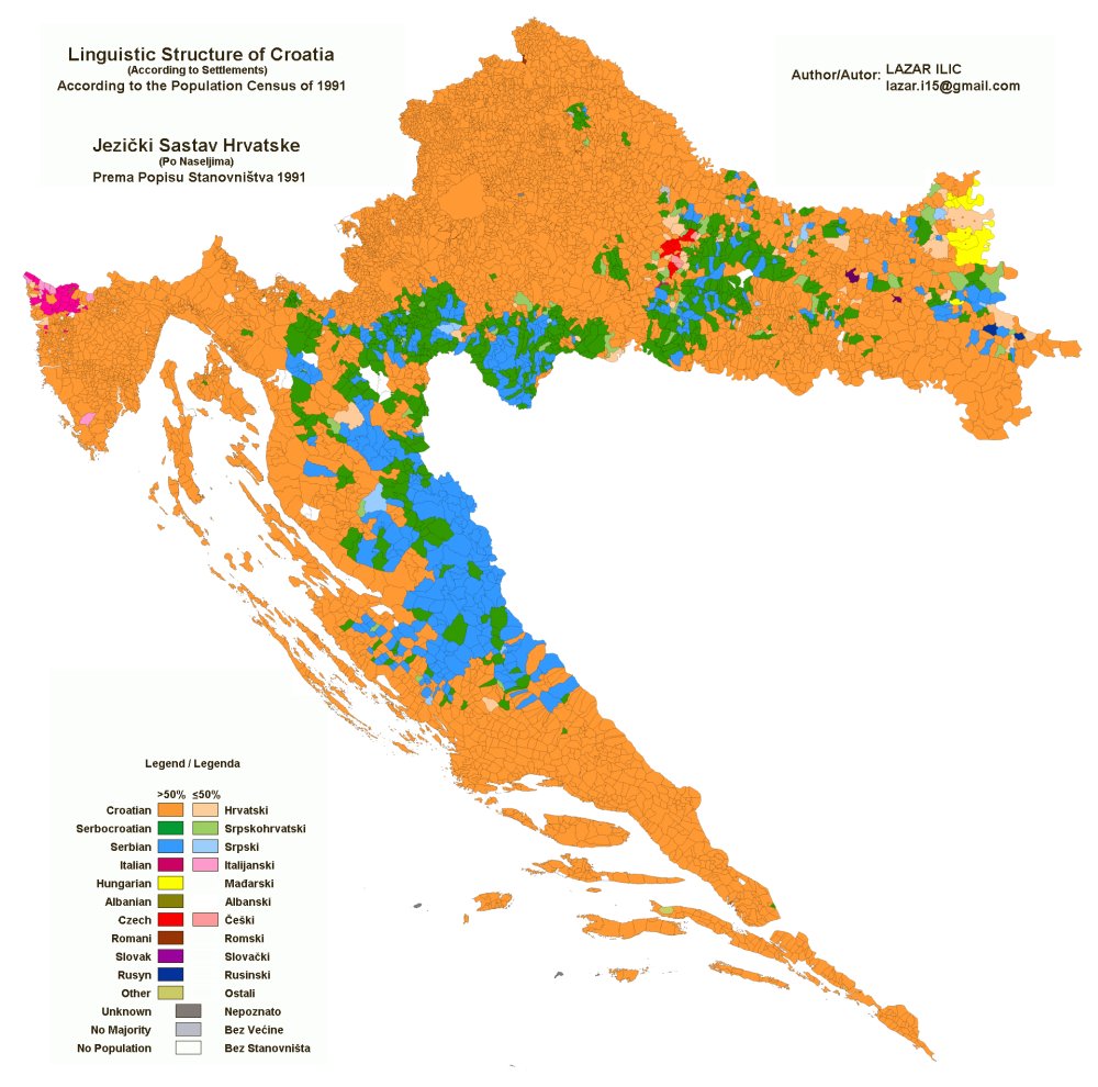
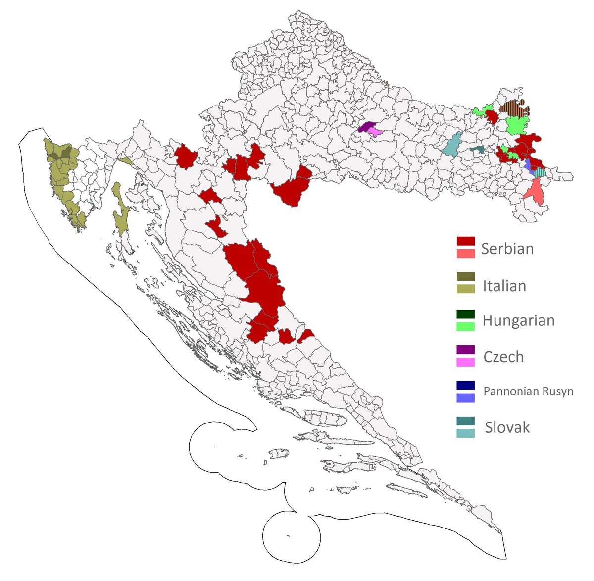
14. Back to 12. & 13., the #genocide & #EthnicCleansing perpetrated vs #Serbs was not the only thing affecting the map.
A process of #Yugoslavization also occurred, turning #Serbian speakers into #SerboCroatian ones, those now turning as #Croatian ones.
That's #Croatianization.🤷♂️
A process of #Yugoslavization also occurred, turning #Serbian speakers into #SerboCroatian ones, those now turning as #Croatian ones.
That's #Croatianization.🤷♂️

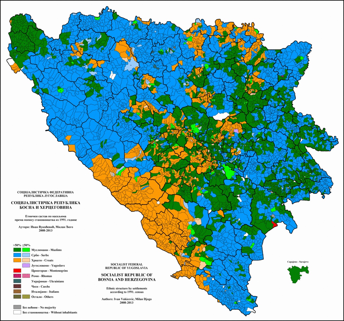
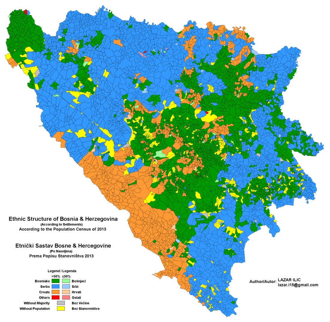
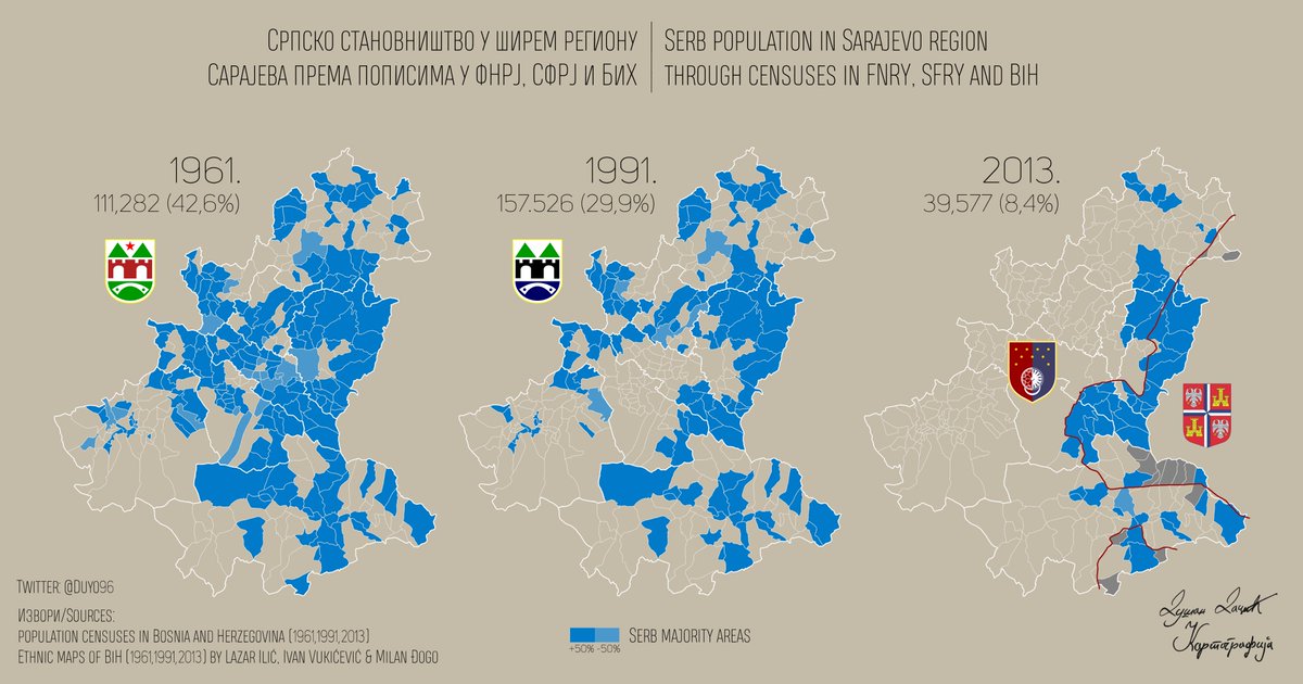
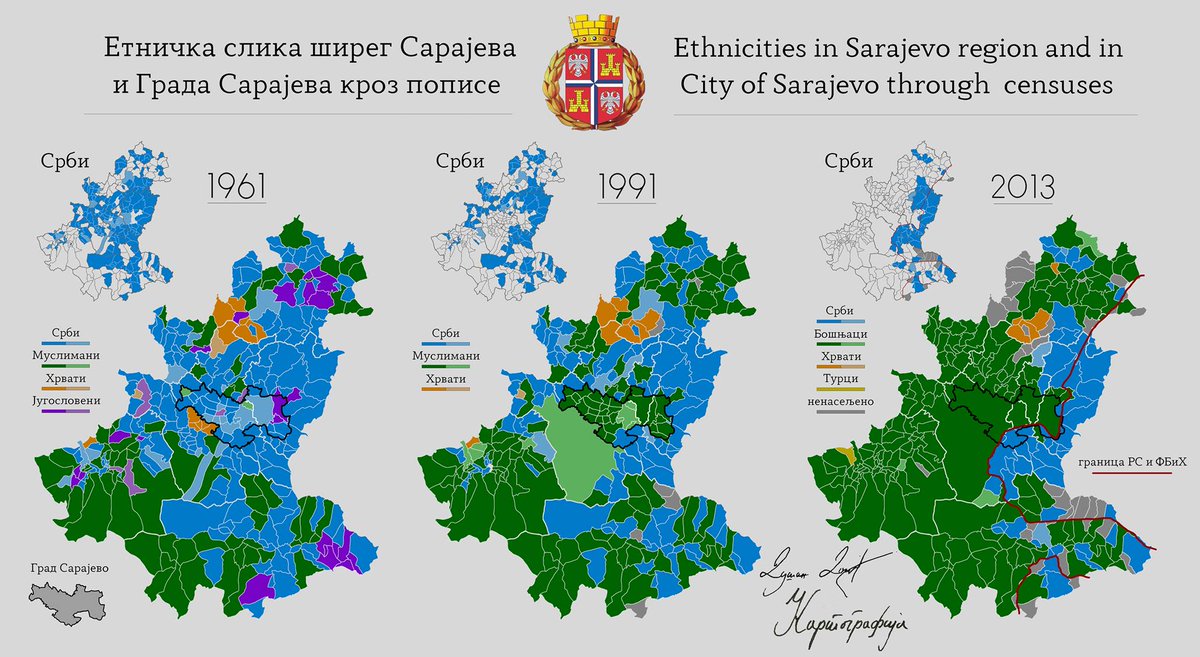
15. While we are on this topic, #Serbs are often blamed for ethnic-cleansing in #Bosnia & #Herzegovina.
W/ reason, because it happened, but w/o cause, because the 3 ethnicities did so toward each other.
What is less known is that in #Sarajevo, it started way before #BosnianWar.😏
W/ reason, because it happened, but w/o cause, because the 3 ethnicities did so toward each other.
What is less known is that in #Sarajevo, it started way before #BosnianWar.😏
16. Now, an animated GIF I compiled w/ census maps of #Kosovo & #Metohija, pertaining to #EthnicCleansing.
Thought it started in 1998?
Just watch!
#Serbs in blue. #Albanians in brown..
Years: 1931, 1953 (WW2 in 1941), 1961, 1971, 1981, 1991, 2011 (2001: ethnic-cleansing spree😏).
Thought it started in 1998?
Just watch!
#Serbs in blue. #Albanians in brown..
Years: 1931, 1953 (WW2 in 1941), 1961, 1971, 1981, 1991, 2011 (2001: ethnic-cleansing spree😏).
17. In the same spirit, let's observe another animated GIF w/ the censuses data representing the sole #Serb population in #Kosovo & #Metohija between 1953 & 2011 w/ 1961, 1971, 1981, & 1991 incorporated.
Every decade, #Serbian villages disappear from the map.😏
Rampant #Genocide?
Every decade, #Serbian villages disappear from the map.😏
Rampant #Genocide?
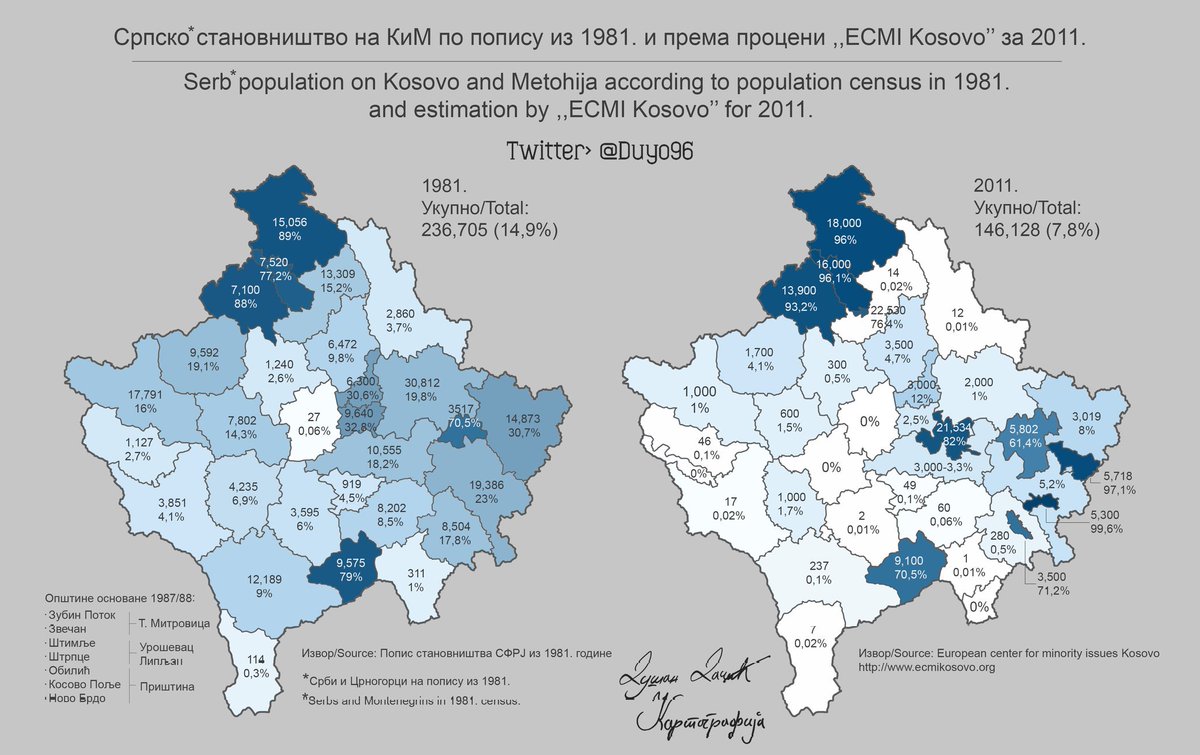
18. For an even clearer picture, let's have a look at @Duyo96 maps in #Kosovo & #Metohija, w/ 2 comparisons:
- 1981/2011, on which the shrinking of #Serbia|n population is already visible & countable.
- 1903/2011, on which an #EthnicCleansing of 70% of Serbian lands is visible.🤯
- 1981/2011, on which the shrinking of #Serbia|n population is already visible & countable.
- 1903/2011, on which an #EthnicCleansing of 70% of Serbian lands is visible.🤯

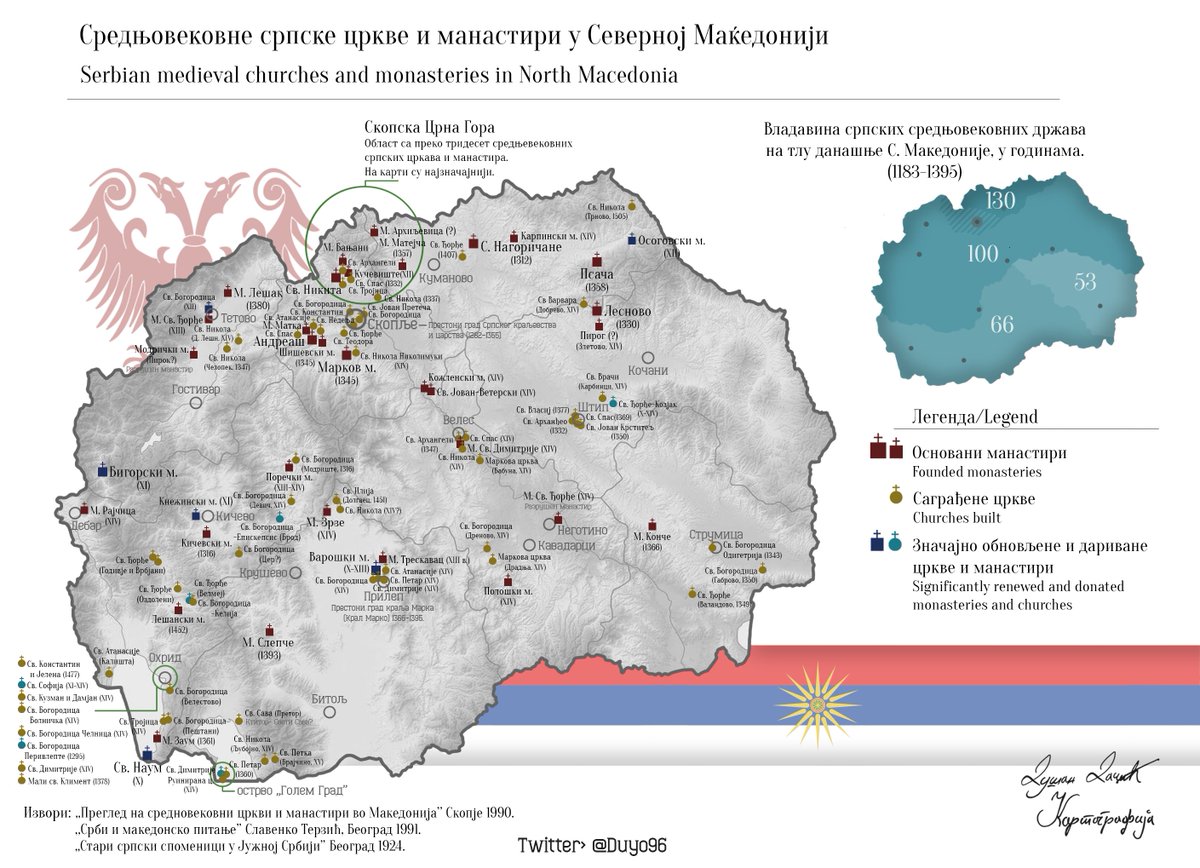
19. Now, let's look at the lands now part of #NorthMacedonia.
This map shows the #Serbia|n #Orthodox medieval Churches.
Built during the #Nemanjici era, they attest of Serbian dominion there before the #Ottoman invasion which lasted more than 500 years before #Serbs liberated it.
This map shows the #Serbia|n #Orthodox medieval Churches.
Built during the #Nemanjici era, they attest of Serbian dominion there before the #Ottoman invasion which lasted more than 500 years before #Serbs liberated it.
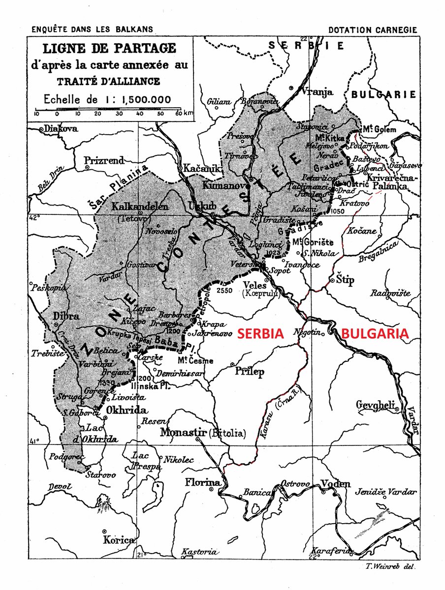
20. In 1912, the liberation of #OldSerbia led to a tough situation.
#Serbia liberated it all, but #Bulgaria wanted at least half & didn't pay its due by supporting Serbian claims over #Adriatic.😏
A wise sharing of #Vardarska was hence denied w/ sad consequences.
Red's my "idea".
#Serbia liberated it all, but #Bulgaria wanted at least half & didn't pay its due by supporting Serbian claims over #Adriatic.😏
A wise sharing of #Vardarska was hence denied w/ sad consequences.
Red's my "idea".
21. Here are 2 maps about the #WW1 occupation of #Serbia by #AustriaHungary & #Bulgaria.
The 1st shows who occupied (& wanted) what.
The 2nd shows Austrian part's subdivisions.
1,000,000 of the 3,500,000 Serbs in🇷🇸died in barely more than 3 years.😱
Atrocious.😭
But🇷🇸prevailed.🙏
The 1st shows who occupied (& wanted) what.
The 2nd shows Austrian part's subdivisions.
1,000,000 of the 3,500,000 Serbs in🇷🇸died in barely more than 3 years.😱
Atrocious.😭
But🇷🇸prevailed.🙏


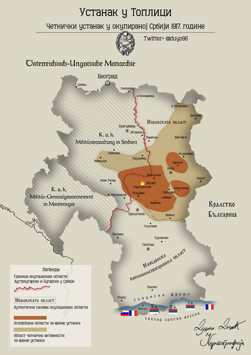
22. On #Bulgaria's occupation of #Serbia, it was the most violent toward civilian populations of the whole WW1.
So violent that Serbian men & women together revolted vs🇧🇬forces (#Toplica uprising), unique situation in WW1.
20k Serbs were killed fighting or as punishment.😱
Horror
So violent that Serbian men & women together revolted vs🇧🇬forces (#Toplica uprising), unique situation in WW1.
20k Serbs were killed fighting or as punishment.😱
Horror

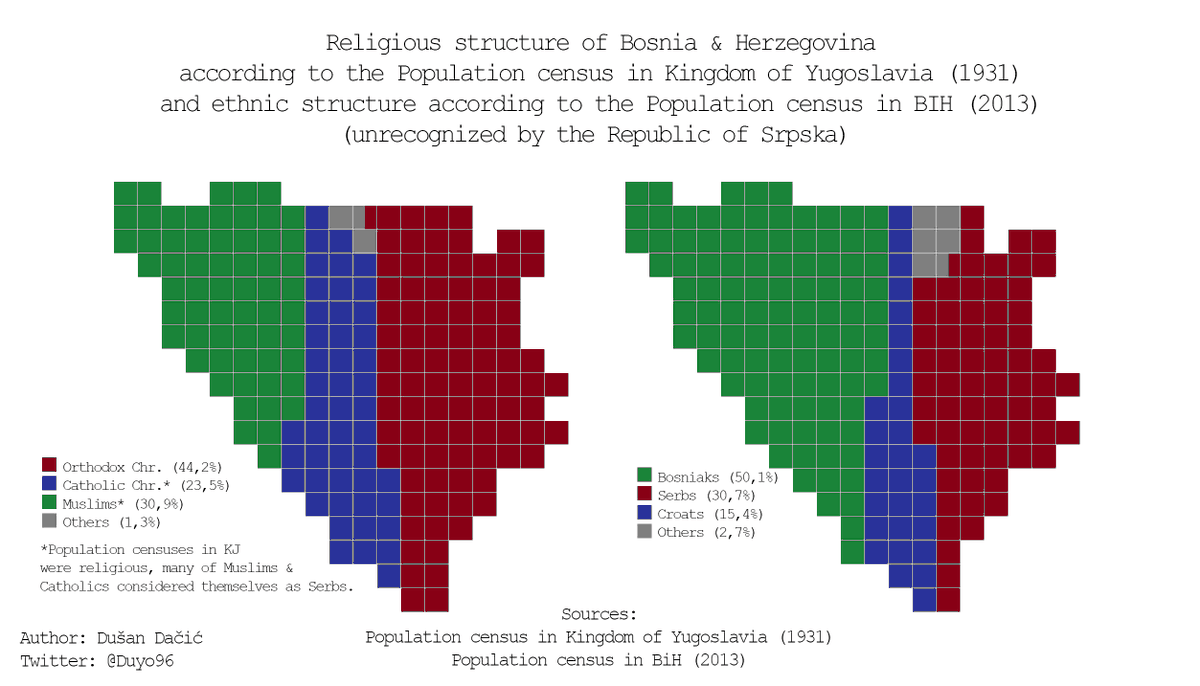
23. Two interesting maps I just found, of the inevitable @Duyo96.
They display, respectively for #Kosovo & #Metohija (1900 - 2011), & #Bosnia & #Herzergovina (1931 - 2013), the evolution of the population there.
In blue, #Serbs. In green, #Albanians/#Bosniaks.
Whose #genocide ?😏
They display, respectively for #Kosovo & #Metohija (1900 - 2011), & #Bosnia & #Herzergovina (1931 - 2013), the evolution of the population there.
In blue, #Serbs. In green, #Albanians/#Bosniaks.
Whose #genocide ?😏

• • •
Missing some Tweet in this thread? You can try to
force a refresh


