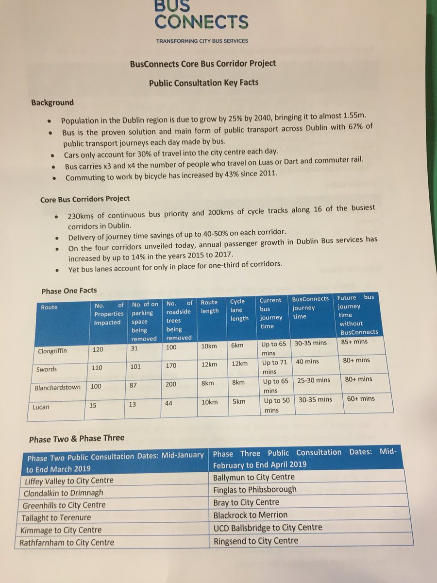
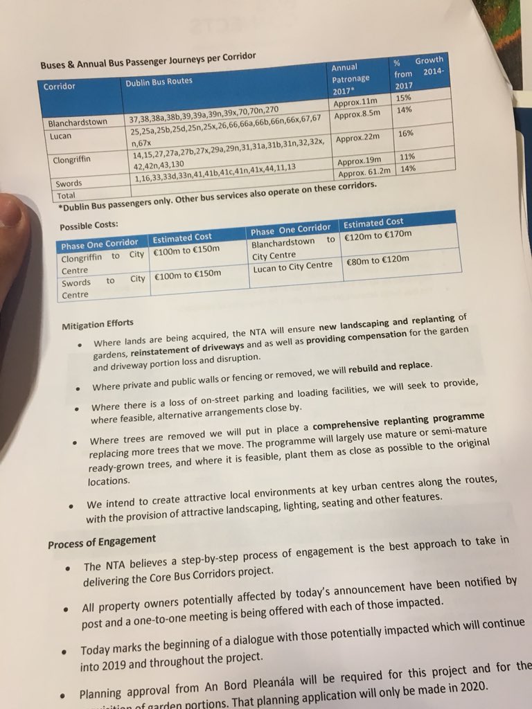
[Thread] The NTA have published new drawings for the #BusConnects Core Bus Corridors. This project aims to deliver 200km of cycle track and 230km of bus lanes in Dublin.
Let's have a deeper look at corridors 6-12 on the south west side of the city.
Let's have a deeper look at corridors 6-12 on the south west side of the city.


Let's start with #BusConnects Core Bus Corridor (CBC) 6 from Lucan to Heuston Station. This route follows the N4/Chapelizod Bypass to the Liffey.
There are some big improvements for cycling along this route.
Maps: busconnects.ie/media/1821/06-…
There are some big improvements for cycling along this route.
Maps: busconnects.ie/media/1821/06-…


The biggest change from a cycling point of view is that the National Transport Authority (NTA) are proposing a two-way cycle track along the north side of the N4 by Hermitage Golf Course.
This was a @dublincycling request to keep people away from heavy traffic.
This was a @dublincycling request to keep people away from heavy traffic.


The NTA are now proposing a two-way cycle track along the Old Lucan Road outside of the M50. In the previous plans this was a wide street with no dedicated cycle facilities.


The NTA are also now proposing a two-way cycle track on Old Lucan Road within the M50 too.
A speed survey by @Love30ie found 86% of drivers breaking the 30km/h speed limit here with almost 15% of drivers doing 50km/h.
A speed survey by @Love30ie found 86% of drivers breaking the 30km/h speed limit here with almost 15% of drivers doing 50km/h.

There are some good looking changes in Palmerstown Village. The previous proposals including a lot of conflict between people cycling and people parking. There are some traffic flow changes here to reduce rat running.


At Chapelizod there is a new set of bus stops being provided on the bypass road. The NTA are also adding a contra-flow cycle lane to Chapelizod Road (currently one-way under the bypass road)


There are improvements to the junction at Con Colbert road that actually protect people cycling. The new designs are far superior here than the old designs imho.


The junction of South Circular Road and St John's Road West hasn't changed and is still a complete disaster for almost every mode of transport.

Closer to the Liffey this route totally just gives up on cycling. It's unclear if the designers know about the proposed Liffey Cycle Route plans for this junction.

#BusConnects CBC7 Liffey Valley goes from the shopping centre through Ballyfermot, Inchicore, Kilmainham to Chirstchurch.
The proposals on the west of the route look great. From Kilmainham in the designers have totally given up on people cycling.
Map: busconnects.ie/media/1822/07-…
The proposals on the west of the route look great. From Kilmainham in the designers have totally given up on people cycling.
Map: busconnects.ie/media/1822/07-…


At Liffey Valley shopping centre there is a proposed bus interchange.
People can walk across the N4 bridge to connect to CBC6 and the buses to Lucan.
People can walk across the N4 bridge to connect to CBC6 and the buses to Lucan.


This junction on the Coldcut Road shows how to protect people cycling while also providing high levels of bus priority.

In Ballyfermot village the NTA are still proposing a one-way section. This will make Ballyfermot less of a through route for traffic to the city. City-bound traffic should be on the N4/Chapelizod bypass imho.


The one-way traffic system, in order to save the beautiful mature trees on Grattan Crescent is included here.
This is because of campaigning by local residents. They want the trees and wider footpaths over more cars: irishtimes.com/news/ireland/i…
This is because of campaigning by local residents. They want the trees and wider footpaths over more cars: irishtimes.com/news/ireland/i…


Skipping to James' Street and Thomas Street. The designers have totally given up. Lots of road widening. Huge gaps in cycle tracks. Mad looking bus stop designs. Plenty of space for private cars. Total lack of imagination by the NTA.
This is #DeathByDesign
This is #DeathByDesign


#BusConnects Core Bus Corridor 8 from Clondalkin to Drimnagh has some interesting and good improvements for people cycling.
This route starts on Nangor Road, via the industrial areas of Long Mile Road to Drimnagh where it joins CBC9.
Map: busconnects.ie/media/1823/08-…
This route starts on Nangor Road, via the industrial areas of Long Mile Road to Drimnagh where it joins CBC9.
Map: busconnects.ie/media/1823/08-…


The biggest issue that @dublincycling had on this route was the junction designs. There are a huge number of HGVs in this area. Large trucks, with their built-in blind spots, are lethal for people cycling.
These two junctions show the NTA want to keep people cycling safe.
These two junctions show the NTA want to keep people cycling safe.


Where Nangor Road meets Long Mile Road and Naas Road is the infamous hamburger junction with the Luas running through the middle of it.
When roads are this large the best thing to do for people walking and cycling is to get them away from it with bridge over the whole junction.
When roads are this large the best thing to do for people walking and cycling is to get them away from it with bridge over the whole junction.


From here CBC8 goes up Naas Road then connects to CBC9 Greenhills at Drimnagh.


#BusConnects Core Bus Corridor 9 Greenhills is from Tallaght, through Walkinstown, Crumlin, Dolphins Barn, Cork Street to Christchurch.
It's one of the longest and most complex routes. I'm going to focus on the cycling sections only.
It's one of the longest and most complex routes. I'm going to focus on the cycling sections only.

On the outer sections of this route there is lots of space and the NTA are starting to use it to protect people walking and cycling.
The plans now include a new bridge over the M50 on the Greenhills Road.
The plans now include a new bridge over the M50 on the Greenhills Road.


Walkinstown Roundabout proposals are interesting. A two-way cycle track around this massive roundabout.
This is an incredibly hard place to design for. These proposals, while still prioritising motor traffic, will be a significant improvement on what currently exists.
This is an incredibly hard place to design for. These proposals, while still prioritising motor traffic, will be a significant improvement on what currently exists.

The NTA are keeping the cycling route on Bunting Road, Kildare Road, while the buses use Walkinstown Road and Crumlin Road.
The cycling route will have dedicated cycle facilities or use traffic filtering to reduce traffic. Continuing cycle tracks on Clogher Road is new.
The cycling route will have dedicated cycle facilities or use traffic filtering to reduce traffic. Continuing cycle tracks on Clogher Road is new.


The NTA are proposing dedicated cycle facilities on this route from the Grand Canal through Dolphins Barn, and Cork Street. This junction design at Dolphins Barn is better. It includes continuous cycle tracks, which is a big improvement.

Cork Street (image 1) continues to have many of the problems of before including parking inside of the cycle lanes. This means no curb protected cycle track but rather a painted cycle lane so cars can access the parking space.
Images 2-3 show parking protected cycle tracks
Images 2-3 show parking protected cycle tracks


This CBC ends at Christchurch. The proposed junction design needs a huge amount of work. It's not at all clear how someone on Christchurch Place can cycle straight given the current proposals.

I'm skipping to CBC11: Kimmage as CBC10 and CBC12 are connected.
CBC11 Kimmage is one of the shortest. There's huge changes from the last public consultation. Including no major road widening, new bus gates and a new cycle way along the River Poddle.
CBC11 Kimmage is one of the shortest. There's huge changes from the last public consultation. Including no major road widening, new bus gates and a new cycle way along the River Poddle.


From the very first map there are huge changes. In order to avoid road widening on Kimmage Road the NTA are adding a bus gate.
The new two-way cycle track an traffic filtering around Poddle Park is new and will create a high-quality cycle route.
The new two-way cycle track an traffic filtering around Poddle Park is new and will create a high-quality cycle route.

Because of the bus gate the road at Sundrive Cross will look like this. Wider footpaths, more trees and better public realm. The bus gates mean the only traffic will be local access traffic. So it will be reasonably safe for cycling along.

There's a quiet cycleway along the Poddle proposed using residential streets and Mount Argus.
I suspect this will be popular for local trips and less confident cyclists. I suspect my today's commuter cyclists will stay on Kimmage Road, which will have significantly less traffic
I suspect this will be popular for local trips and less confident cyclists. I suspect my today's commuter cyclists will stay on Kimmage Road, which will have significantly less traffic


All kinds of traffic changes including bus gates are proposed at the triangle in Harold's Cross.
The narrow and windy cycle route proposed through Greenmount industrial estate is gone and replaced by cycle tracks on Harold's Cross Road.
The narrow and windy cycle route proposed through Greenmount industrial estate is gone and replaced by cycle tracks on Harold's Cross Road.


There is a proposal to significantly widen and improve Harolds Cross Bridge. This is a major pinch point for people walking, cycling, using the bus or driving.
I think there are hints in this about future Grand Canal Cycleway extensions.
I think there are hints in this about future Grand Canal Cycleway extensions.

The cycle tracks up Clanbrassil Street are now continuous. The old proposals had large gaps in the cycle tracks. Now the NTA are proposing to use bus priority lights at South Circular Road to avoid needing a bus lane for about 100m to make space for cycling.


There are improvements planned for Patrick Street too that maintain the trees in the median. D8 needs all the greenery it can get so this is a big improvement.
Here CBC11 connects to CBC9 up to Christchurch.
Here CBC11 connects to CBC9 up to Christchurch.

Now. Back to #BusConnects Core Bus Corridor 10 Tallaght to Terenure.
Templeogue is still a massive question mark. Spawell roundabout is to be replaced with a signalised junction. Otherwise minor junction changes and improvements.
Map: busconnects.ie/media/1809/10-…
Templeogue is still a massive question mark. Spawell roundabout is to be replaced with a signalised junction. Otherwise minor junction changes and improvements.
Map: busconnects.ie/media/1809/10-…


Templeogue is a massive question mark.

There are some minor changes and alterations closer to Terenure. There will be a bus gate inbound just before Terenure Village in order to provide bus priority.


#BusConnects Core Bus Corridor 12: Rathfarnham is probably the most controversial of the lot with many communities completely unhappy with the last proposals liberal use of road widening and tree removal.
Huge number of changes to almost everything.
Map: busconnects.ie/media/1811/12-…
Huge number of changes to almost everything.
Map: busconnects.ie/media/1811/12-…


There's two new detours for cycling around Rathfarnham Village. The old detour via Brookvale downs is gone.
This new detour could have huge environmental impact to create an indirect cycle route. I'm not convinced by any of this on first glance.
This new detour could have huge environmental impact to create an indirect cycle route. I'm not convinced by any of this on first glance.


At Terenure Village the cycle route will head straight on down Terenure Road North to Harolds Cross. There will be no cycle facilities on Terenure Road East.
Second image shows wider footpaths for Terenure Village.
Second image shows wider footpaths for Terenure Village.


Terenure Road East will see significantly less road widening. There will be no dedicated cycle facilities here.
I've shown the old versus new proposals below. Look at what is being lost in order to avoid road widening into some of the largest gardens in Dublin.
I've shown the old versus new proposals below. Look at what is being lost in order to avoid road widening into some of the largest gardens in Dublin.


To reduce road widening on Rathgar Road and to save many trees the road will be made one-way with dedicated cycle facilities in both directions. A huge improvement in my opinion.


Rathmines Road is where the magic happens. In order to provide wide footpaths and dedicated cycle tracks. The NTA are proposing to install a bus gate on Rathmines Road by St Mary' College. This means no through traffic but people can access the house/shops/schools etc. by car


By adding the bus gate the NTA can provide more space for public realm, walking and cycling while maintaining high levels of bus priority.

At LaTouche Bridge (Portobello Bridge) the NTA are proposing a bus gate inbound. This makes space for dedicated cycle lanes here.

There are poor decisions around Camden Street with gaps in the cycling routes. On George's Street the road will be reduced to two motor traffic lanes with dedicated cycle tracks. That's the end of CBC12.


That concludes the south west corridors (CBC6-12) of BusConnects. I need to go read the remaining south east corridors CBC13-16 now.
No one could accuse the NTA of not listening to the public. They've made huge changes to their proposals across every single corridor.
BusConnects has huge oppurtunity to make:
* Make buses more reliable and faster
* Enable cycling for all
* Create community public space
BusConnects has huge oppurtunity to make:
* Make buses more reliable and faster
* Enable cycling for all
* Create community public space
If you're interesting in the northside corridors I did another twitter thread for those here: