The Horn of Africa this morning @NASA worldview, got a great view and more pictures will be included in today's rainfall forecast thread for #Ethiopia #HoA and the #MiddleEast.
Today's forecasts follow.
Today's forecasts follow.

Here's the first. A view mostly of #Sudan, capturing both the #WhiteNile and #BlueNile as well as part of the Nile below Sudan on its way to Egypt. On the right hand side Lake Tana can be seen through the clouds.
If you look very carefully you may be able to see #GERD.
If you look very carefully you may be able to see #GERD.

This view which captures the area below that in the previous image has borders on it to make it easier to see where the abundant green in the firsy image in this thread is located. The rains of the past few weeks appear to be doing God's work in the region. 

Here you see an animated forecast of the precipitable water in this years extremely active #WestAfricanMonsoon . It shows the next 10 days.
This images shows a 10 day forecast of rain across North Africa from the same CMC model.
While it is unusual to see so much rain forecast in the Sahara there are many things which appear to be unusual about the weather we are experiencing this year across the entire hemisphere.
While it is unusual to see so much rain forecast in the Sahara there are many things which appear to be unusual about the weather we are experiencing this year across the entire hemisphere.

Finally before the forecasts here is an animation from 10am to 1pm today of winds & storms across the #HornOfAfrica and the Southern end of the Arabian Peninsula.
These winds have been causing chaos in #Oman and helping bring welcome rains to the #UAE.
These winds have been causing chaos in #Oman and helping bring welcome rains to the #UAE.
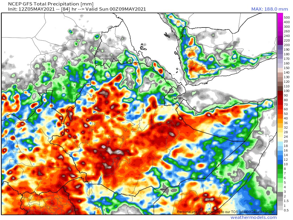
May 5th, 10-day accumulated rain forecasts, for Ethiopia and the Horn of Africa from the
@ECMWF , GFS and KMA weather models.
#Sudan #SouthSudan #Ethiopia #GERD #Africa #HornOfAfrica #DesertRain


@ECMWF , GFS and KMA weather models.
#Sudan #SouthSudan #Ethiopia #GERD #Africa #HornOfAfrica #DesertRain


& a new regular feature from now.
May 5th, 3-day accumulated rain forecasts, to Midnight Saturday, for Ethiopia and the Horn of Africa, again from the @ECMWF , GFS and KMA weather models.


May 5th, 3-day accumulated rain forecasts, to Midnight Saturday, for Ethiopia and the Horn of Africa, again from the @ECMWF , GFS and KMA weather models.


Last night the winds shown in the earlier animation above caused spectacular #ArabianStorms in #Oman some of which caused a lot of damage and flooding.
You can follow @Arab_Storms for eyewitness reports.
You can follow @Arab_Storms for eyewitness reports.
Here is a report from during the storm in Oman.
https://twitter.com/Arab_Storms/status/1389706030389596165?s=20
And another....
https://twitter.com/Arab_Storms/status/1389701249562521605?s=20
... and another.
https://twitter.com/Arab_Storms/status/1389700658501087232?s=20
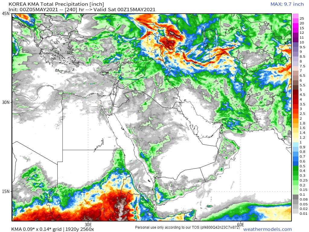
Here are today's, May 5th, 10 day accumulated rain forecasts, for the #MiddleEast from the GFS, ECMWF, CMC & KMA weather models.
@Arab_Storms
#ArabianStorms
#KSA #Yemen #Oman #Jordan #Sudan #Iran #Syria #GERD #Sudan #DesertRain
الله أعلم


@Arab_Storms
#ArabianStorms
#KSA #Yemen #Oman #Jordan #Sudan #Iran #Syria #GERD #Sudan #DesertRain
الله أعلم


And here are today's May 4th, 3 day accumulated rain forecasts (to Saturday at Midnight), for the #MiddleEast from the GFS, ECMWF, CMC & KMA weather models.
@Arab_Storms
#ArabianStorms
#KSA #Yemen #Oman #Jordan #Sudan #Iran #Syria #GERD #Sudan #DesertRain
الله أعلم


@Arab_Storms
#ArabianStorms
#KSA #Yemen #Oman #Jordan #Sudan #Iran #Syria #GERD #Sudan #DesertRain
الله أعلم


Also last night, there was for I think the fourth time (but please correct me if I am wrong) rain in the Holy City of Mecca on the #HolyKaaba, a relic of the shared ancestor in faith of all the Abrahamic religions, Abraham of Ur.
https://twitter.com/althecat/status/1389964217420296194?s=20
And the final forecast for tonight is also for the #MiddleEast and includes forecasts from the two ultra-long range computer model forecasts, NOAA's 16-Day GFS (of which the GEFS is the Ensemble version - averaging out many model runs) and Korea's 12 day KMA model. 


And to end today's rainfall forecast thread here is another Satellite picture of the the source of the Nile - Lake Victoria in Uganda.
And I would like to make a shout out to a friend who is presently visiting there. @anacascao.
And I would like to make a shout out to a friend who is presently visiting there. @anacascao.

• • •
Missing some Tweet in this thread? You can try to
force a refresh


