,
15 tweets,
5 min read
Read on Twitter
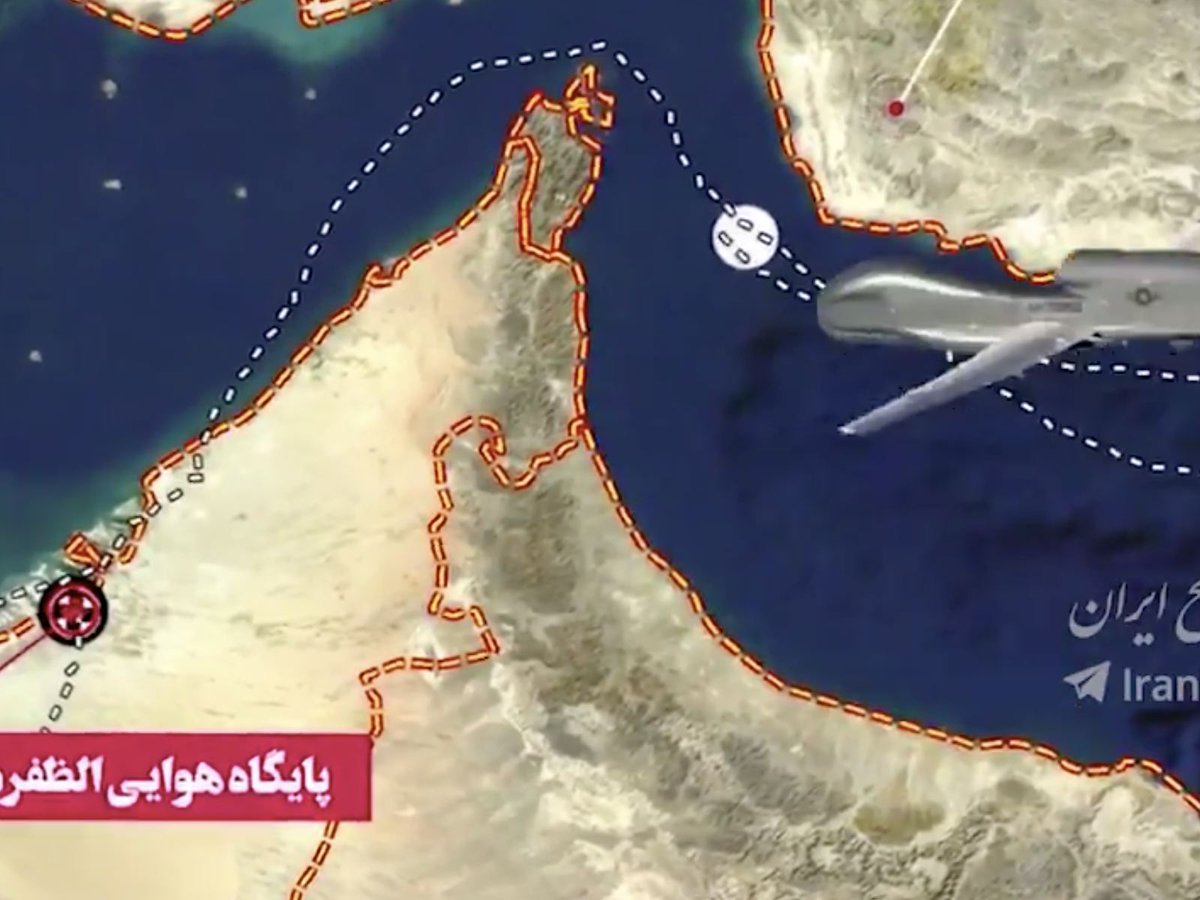
1/ US and Iranian maps of drone flight path are very similar except for divergence at end. Drone originated near Umm al Qaywain, flew around Khasab, then east in Gulf of Oman in Iranian ADIZ, but just outside 12-mile territorial seas; then turned around and returned westbound. 
2/ Iran map shows westbound route several miles to north of eastbound route; US map shows re-tracing W close to eastbound route. In US case, final azimuth ~330; Iran ~340. In Iran map, drone strays into Iranian territorial waters.
3/ other information comes from US image which regrettably lacks explanation. At 23:39:26 GMT, ACFT at 25.9575N, 56.87556E, 22200 feet (6768 m), 144 deg; TGT at 25.96167N 56.97278E, 277 deg, 4.295M. Also note N arrow pointing more or less horizontal. What does it all mean?

4/ do degrees (ACFT - 144; TGT 277) represent azimuth of flight path? Seems most logical to me.
Is 4.295M miles? Then TGT at 22677 ft, a little higher than ACFT at 22200 feet.
Is ACFT the drone and TGT the SAM missile? Maps show drone more or less at ACFT location.
Is 4.295M miles? Then TGT at 22677 ft, a little higher than ACFT at 22200 feet.
Is ACFT the drone and TGT the SAM missile? Maps show drone more or less at ACFT location.
5/ a rough sketch of locations of ACFT, TGT (photo) and Iran location relative to SAM launch site (US map) and coast. Puzzles. Drone known to be traveling NNW (~330 azimuth), but 144 in photo. Missile originated almost due N of drone, but azimuth in photo is ~due W (277). Ideas??

6/ I've been wondering about other drone incidents. On Nov 11, 2017, Israel shot down timesofisrael.com/idf-missile-de… Syrian drone in Syrian territory "after the unmanned aircraft approached Israeli border from Syria…IDF later concluded that aircraft...did not enter Israeli territory"
7/ to my recollection, US did not go into hysterics about sanctity of airspace when Syrian drone shot down.
8/ Charles Wood sent me article on radar display gizmodo.com.au/2014/10/how-fi…. Though not the same display, it refers to both heading of target and aspect angle between observer flight path and target flight path.
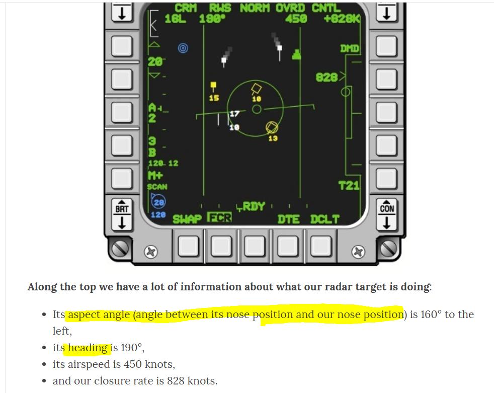
9/ here's a guess (and no more than a guess) on how to interpret photo (assuming that ACFT is drone and TGT is missile): 277 deg is bearing(heading) of missile ie ~due west; 144 deg is aspect angle. Implies ACFT heading of 277+(180-144)= 313 ie ~NW. TGT still ~ 7.7 km away.

10/ here's a revised sketch indicating that this interpretation is probably correct. I assumed that missile is ~Mach 2.5 and experimented with drone speeds. At drone speed of 445 mph, the two paths are within 1 meter at 13.755 seconds in future at 25.97605N 56.85566E

11/ this indicates very strongly that missile originated almost due east of shoot-down location as indicated on Iranian information, NOT from the north as shown on the US map.


12/ here's a better sketch against map showing 12-mile boundaries. One loose end: azimuth in flight in US map appears more N-S than deduced from photo. Outbound azimuth was ~162.5, implying return 342.5. From photo, 313. Range shown as dotted lines.


13/ bottom line is that data in radar image indicate impending shootdown 13 seconds in future close to location shown in US map, not Iranian map. It's within Iranian ADIZ, but outside 12 mile territorial waters. Heading of drone indicated by radar image is about 28 deg flatter
14/ than outbound flightpath in US map (They show return flightpath more or less re-tracing). If the observed drone heading had been in place for the previous 2.5 minutes or so, it would imply that it had been in Iranian territorial waters in interval prior to 2.5 minutes before
15/ however, this is far from showing that this happened. Either the Iran map is fraudulent or the US radar image is fraudulent. Even tho US flight paths in Iranian ADIZ appear taunting and provocative to me and I loathe warmongering, on balance, I'm skeptical of Iranian map.