I get a lot of questions about my @locatepress book Discover QGIS 3.x. There is a lot - it's 402 pages with 32 lab exercises. To begin 2020 I'll be launching the #30DaysofDiscoverQGIS3x thread highlighting things you can learn/teach with this workbook! Stay tuned! #gischat #QGIS 
@locatepress This workbook has 5 sections: 1) Intro to Geospatial Technology, 2) Spatial Analysis, 3) Data Acquisition and Mgmt, 4) Cartography and 5) Advanced Data Visualization. It can be purchased as an ebook or paperback at locatepress.com/dq3 #30DaysofDiscoverQGIS3x
@locatepress There is a New Years sliding scale sale on all ebooks at locatepress.com. Starting today the discount will be 50% using the code: newyears
The discount steps down each day by 5%. Get in early!
Sale starts midnight EST Dec 30.
#30DaysofDiscoverQGIS3x
The discount steps down each day by 5%. Get in early!
Sale starts midnight EST Dec 30.
#30DaysofDiscoverQGIS3x
@locatepress Day 1 of #30DaysofDiscoverQGIS3x: Part 1 - Ex #1 introduces spatial data models: vector and raster. #GDAL and #OGR are introduced along with characteristics of numerous common file formats. Learn to explore and add data to #QGIS via the Browser panel & the Data Source Manager
@locatepress Day 1 of #30DaysofDiscoverQGIS3x extra tip: In Part 1 - Ex #1 you also learn how to manage panels so that they are tabbed, making more efficient use of your desktop. Also learn to set your project folder as a Favorite to make it easy to find
@locatepress Day 2 of #30DaysofDiscoverQGIS3x: In Part 1 - Ex #2 learn to create a sage-grouse habitat map. You add the data, set the project CRS, use zoom/pan tools, change layer drawing order & symbolize data. Along the way learn how to copy/paste styles & use the Layer Styling Panel
@locatepress Day 2 of #30DaysofDiscoverQGIS3x: Part 1 - Ex #2 continued - with the data styled you learn to use the Print composer. Add a title, customize the legend and use an expression to automate the date. This lab includes a challenge exercise, discussion questions & the solution.
@locatepress Day 3 of #30DaysofDiscoverQGIS3x: Part 1 - Ex #3 builds from working with existing data to creating data. Teach students to georeference a scanned map and digitize parcel boundaries from it. The challenge exercise involves digitizing roads from aerial photographs.
@locatepress Day 4 of #30DaysofDiscoverQGIS3x: Part 1 - Ex #4 teaches concepts around multi-band raster imagery including band combinations. Students then delve into performing an unsupervised classification. The #QGIS processing toolbox & #SAGA are introduced. #gischat #remotesensing
@locatepress Day 5 of #30DaysofDiscoverQGIS3x: The final exercise of Part 1 builds on the previous 4 taking a small project from beginning to end. Start with raw data - work with CRSs, prepare data with several geoprocessing tools, use filter expressions, & design a map composition. #QGIS
@locatepress On day 6 of #30DaysofDiscoverQGIS3x we move into Part 2 Spatial Analysis. The 1st exercise is a combination of a review & an intro to the #QGIS DBManager & the #Spatialite geodatabase. Exercise 2 teaches to create a join and then moves into data classification techniques #gischat
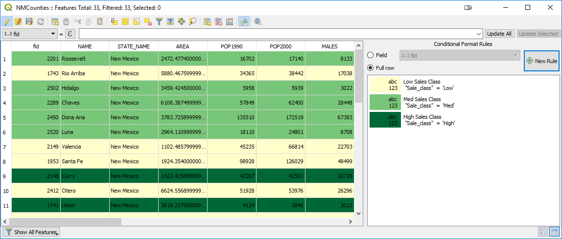
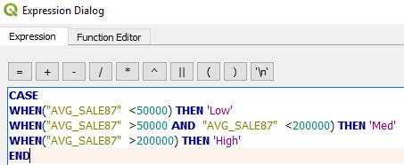
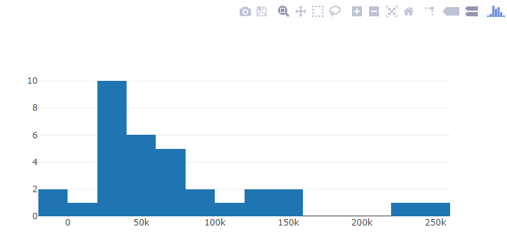
@locatepress Day 7 of #30DaysofDiscoverQGIS3x Part 2 Ex#3 focuses on tables including some tricks. Learn to query by attributes, add/remove fields, calculate values, use case statements, generate histograms, create charts via #DataPlotly & set up conditional table formatting #QGIS #gischat
@locatepress Day 8 of #30DaysofDiscoverQGIS3x
Part 2 Ex#4 introduces vector overlay analysis in #QGIS. Learn to use the Overlay algorithms in the Processing Toolbox to identify the area of critical habitat overlap between two bird species, then calculate the amount in each admin area #scgis
Part 2 Ex#4 introduces vector overlay analysis in #QGIS. Learn to use the Overlay algorithms in the Processing Toolbox to identify the area of critical habitat overlap between two bird species, then calculate the amount in each admin area #scgis
@locatepress Day 9 of #30DaysofDiscoverQGIS3x
Part 2 Ex #5 is a thorough intro to the #QGIS graphical modeler. The task is developing a site selection model to determine the optimal locale for a heliport. Many tips & tricks are provided along the way #gischat #foss4g #modeling #giseducation
Part 2 Ex #5 is a thorough intro to the #QGIS graphical modeler. The task is developing a site selection model to determine the optimal locale for a heliport. Many tips & tricks are provided along the way #gischat #foss4g #modeling #giseducation
@locatepress Day 10 of #30DaysofDiscoverQGIS3x Part 2 Ex #6 teaches how to do network analysis with the native #QGIS Network Analysis algorithms. Learn to compute both shortest & fastest routes, along with service areas. Discussion Q's, Challenge Ex & solution files included #foss4g #gischat
@locatepress Day 11A of #30DaysofDiscoverQGIS3x Part 2 Ex #7 introduces elevation raster data. In Task 1 learn about the Hillshade renderer. Blending modes are also introduced & used to generate a color hillshade. Learn to generate slope & aspect from the dem via Raster Terrain Analysis algs.
@locatepress Day 11B of #30DaysofDiscoverQGIS3x In tasks 2 & 3 learn to use the Reclassify by Table algorithm & put rasters into meaningful categories for a site selection analysis. Then use the reclassified rasters in the Raster Calculator to identify suitable sites for a plant species.
@locatepress Day 12 A of #30DaysofDiscoverQGIS3x Part 2 Ex #8 teaches how to create raster density surfaces from points via both the Heatmap point renderer & the Heatmap toolbox alg. Raster<-->vector conversion is taught.
@locatepress Day 12 B of #30DaysofDiscoverQGIS3x Another gem in this exercise is introduction to the relatively new and paradigm changing processing feature called Editing in Place. Run processing on a layer in place - without needing to save out to a new layer.
@locatepress This wraps up Part 2 of Discover QGIS 3x - Spatial Analysis. The coming week will move into Part 3 - Data Acquisition and Management beginning tomorrow with @postgis.
@locatepress
locatepress.com/dq3
#30DaysofDiscoverQGIS3x #gischat
@locatepress
locatepress.com/dq3
#30DaysofDiscoverQGIS3x #gischat
@locatepress @postgis Day 13 of #30DaysofDiscoverQGIS3x Part 3 - Ex 2 teaches how to:
set up a @postgis DB
import data (FGDB, @shapefiIe & KML)
work with PgAdmin4 (DBeaver listed as an alternative)
& run some spatial SQL via the #QGIS DB Manager.
This is where QGIS really begins to get powerful!
set up a @postgis DB
import data (FGDB, @shapefiIe & KML)
work with PgAdmin4 (DBeaver listed as an alternative)
& run some spatial SQL via the #QGIS DB Manager.
This is where QGIS really begins to get powerful!
@locatepress @postgis @shapefiIe Day 14 of #30DaysofDiscoverQGIS3x Part 3 - Ex 3 teaches how to test data for invalid geometries with the Topology Checker Panel. Vector editing is introduced to correct errors. Along the way the concept & #QGIS implementation of snapping tolerances is explained. #giseducation
@locatepress @postgis @shapefiIe Day 15 of #30DaysofDiscoverQGIS3x Part 3 - Ex 4 focuses on investigating spatial data quality. Learn to map delimited text coordinates including an intentional error the student must correct. Then everyone's favorite topic - what is metadata & how does #QGIS implement Dublin Core
@locatepress @postgis @shapefiIe Day 16 of #30DaysofDiscoverQGIS3x In Part 3 Ex 5 you learn more about working with rasters. Learn: how to create a mosaic with the #GDAL Build Virtual Raster alg, what raster pyramids are & how to generate them, & how to clip a raster dataset. Challenge involves the SRTM plugin
@locatepress @postgis @shapefiIe Day 17 of #30DaysofDiscoverQGIS3x The final exercise of Part 3 teaches the principles behind address geocoding and how to do accomplish it with #QGIS. Learn to use the MMQGIS plugin to geocode via both a street layer or web services
@locatepress @postgis @shapefiIe This wraps up Part 3 of Discover QGIS 3x - Data Acquisition and Management.
Tomorrow I will move into Part 4 - Cartographic Design - the first exercise covered will be Map Composition. Stay tuned!
@locatepress
locatepress.com/dq3
#30DaysofDiscoverQGIS3x #gischat
Tomorrow I will move into Part 4 - Cartographic Design - the first exercise covered will be Map Composition. Stay tuned!
@locatepress
locatepress.com/dq3
#30DaysofDiscoverQGIS3x #gischat
@locatepress @postgis @shapefiIe Day 18A of #30DaysofDiscoverQGIS3x Part 4 Ex 1 is a thorough treatment of map composition in #QGIS. Building on what has been taught so far it begins w/2 use cases for Inverted Polygon Shapeburst Fills. Then design a print composition w/ some tricks using variables & expressions
@locatepress @postgis @shapefiIe Day 18B of #30DaysofDiscoverQGIS3x In the final task of Part 4 Ex 1 learn to set up Map Themes & create a second locator inset map. Also see an example of the Raster Image Marker introduced at #QGIS v3.6! The topic is the site of last years QGIS User Conference: A Coruña (Spain)
@locatepress @postgis @shapefiIe We're on day 19 of #30DaysofDiscoverQGIS3x In Part 4 Ex 2 you learn how to create Atlases in the #QGIS Print Composer. You learn all the settings and how to use Atlas variables to create more sophisticated Atlases. Rule based rendering is also introduced. #gischat
@locatepress @postgis @shapefiIe Day 20 #30DaysofDiscoverQGIS3x Part 4 Ex 3 is a thorough treatment of coordinate reference systems & map projections in #QGIS. Learn how to define a custom CRS. #DidYouKnow in QGIS3x you can run processing algs against layers in different CRSs & there is a valid extents preview!
@locatepress @postgis @shapefiIe Day 21 of #30DaysofDiscoverQGIS3x Part 4 Ex 4 covers some tricks to improve your labeling. Learn best practices for halos, avoid repeats, use labeling expressions, manually place labels, avoid truncated labels & avoid label conflicts w/ items in a map composition #gischat #QGIS
@locatepress @postgis @shapefiIe Day 22 of #30DaysofDiscoverQGIS3x The last exercise in Part 4 builds your layer styling skills. Learn the power of expressions & data defined overrides w/ symbology in #QGIS. Here you recreate a historic map of US states by mixing shapeburst fills with a random dot boundary
@locatepress @postgis @shapefiIe This exercise also showcases the Topological Coloring tool introduced at #QGIS 3.0. #30DaysofDiscoverQGIS3x
@locatepress @postgis @shapefiIe This wraps up Part 4 of Discover QGIS 3x. The final week of #30DaysofDiscoverQGIS3x will focus on the last section - Advanced Data Visualization. Stay tuned!
@locatepress
locatepress.com/dq3
#gischat
@locatepress
locatepress.com/dq3
#gischat