I would like this morning to deal with a troubling subject. Why does London Road have an almost imperceptible kink in it through Abbeyhill, and why does Lower London Road lead off it at a super acute angle, only to reconnect further up? 


Let's start with a little bit of background on London Road. The name is obvious in its root; it was the route to the east (therefore South) out of the city. It was planned in the early 19th c. as part of the Calton New Town, the final phase of expansion of Georgian Edinburgh.
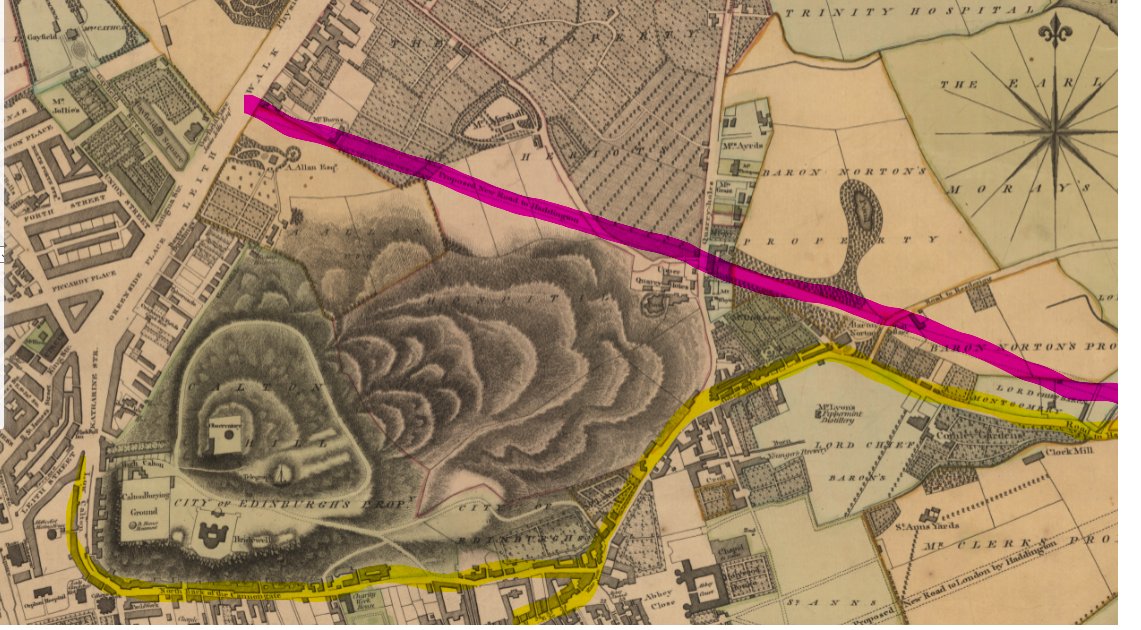
Ainslie's map of 1804 shows the tortuous route into the city from the east, along what is now Royal Park Terrace and Spring Gardens to Abbeyhill and the Canongate and around the south flank of Calton Hill. A new road was planned to bypass the lot (attribution: NLS)
The land through which this phase of the New Town would run was owned by Heriot's Hospital (to the west) and Baron Norton (to the east). The latter lent his name to Norton Park, the old area for the land at the top of Easter Road and recalled in a few current street names.
Bringing the main route into Edinburgh around the north of Calton Hill was made possible by the spanning of the Nor' Loch ravine by North Bridge. But not a lot happened for some time as various schemes and counter schemes were proposed. Below is Playfair's 1819 plan.

This shifted the route of the road somewhat to the south, this was done to improve the vistas to the north from Royal Terrace, and was possible because Regent Bridge had been completed, allowing the main approach to run up Regent Road along the south shoulder of Calton Hill
Anyway, by around 1820, London Road had been completed (or was under construction) from Jock's Lodge to the top of Leith Walk. The section through Meadowbank crossed the old "irrigated meadows" (see previous thread), and required substantial groundworks

The 1849 Town Plan shows London Road between Easter Road and Jocks Lodge as a dead straight in the best traditions of road building. (attribution: NLS)

So, we have a problem. That isn't the current alignment of "London Road".
Or is it... it's actually the alignment of Lower London Road. Lower London Road, you see, is actually the original alignment. Really we should call the bit between the Waverley Place and Wishaw Terrace "Upper London Road"

So how did that happen then? Why shift such a major road a few feet to the north. The answer can be found if we move to the 1876 town plan. Someone (the North British Railway) had decided to build a railway under it. (NLS)

In the 1860s, tired of the impracticalities of running trains from Granton and Leith into Waverley up the Scotland Street tunnel (yellow), the North British planned a diversion loop around Calton Hill instead (green), with a spur to the east to connect to the main line.

The "Abbeyhill Diversion" peeled off the east coast line at Abbehill Junction, before turning back on itself and heading under Easter Road and Leith Walk, before joining the old alignment at Trinity. But to do this it had to get under London Road and those other two main streets.
The town council mandated that the widths and alignments of Easter Road and Leith Walk be maintained, but that was not practical for London Road, so the whole thing was rebuilt slightly to the north to cross over the top of the railway.
(Footnote, this is also how Easter Road acquired itself a blind summit about 1/3 of the way down where it crosses over the railway, it's not the original road level)

So it's obvious now *why* London Road was realigned, but why was Lower London Road maintained? The answer lies within Comely Green Place and Crescent, a small Georgian development where Abbeyhill met London Road and Marionville Road. It was mandated that access be retained.

Comely Green (yellow) is on the left, Abbeyhill (diverted now as Abbey Lane (green) beyond, with "Lower" London Road in blue, which now runs up on the embankment to the right. The steps were provided to give access up to the new alignment from Comely Green.

A similar set of steps was built further east to give access from Taylor Place (there's a right of way here under the east coast main line railway)

At Abbeyhill, once the church (blue) and tenements of Cadzow place (green) were built and filled in the difference between new road height and the former level, the change became much less recognisable.

The Abbeyhill Colonies soon appeared to provide workers housing for the railway, malting and iron foundry industry around Abbeyhill and Meadowbank, with awkwardly steep approaches to London Road which would later be stepped as was done at Carlyle/Salmond Place.

Cadzow Place was constructed in 1897, so within 30 years of the railway opening in 1869, Abbeyhill as we now know it was fully formed (apart from those missing steps.)
At its eastern end, now amount of pavement build-out can hide the original alignment of London Road

Looking west,the awkwardness of the turn out of Lower London Road is engineered by that buildout. Realistically, LLR should not be open as a throughway - it's effectively a car park, the speed bumps are useless, and its used as a rat run to avoid the lights on London Road.

Amusingly (or not), the retaining wall between the two levels is now beginning to collapse, probably a combination of age, lack of maintenance, the spread of trees in that narrow embankment and the weight and speed of traffic on the higher level.
Interestingly, the Corporation's 1972 plan had LLR marjed down as for development into a busway

At this point, all the housing along LLR with only a few exceptions was demolished (or about to be), so it probably seemed surplus to requirements. The dot and line sections were "Bus priority", from Willowbrae into the city centre via Regent Road.
The scheme is dropped in the 1974 plan, and barely merits a mention in the 1972 plan, but that's par for the course. Transport planning in Edinburgh in the 1960s and 70s was 99% "where can we build big new roads?" with some afterthoughts given to buses.