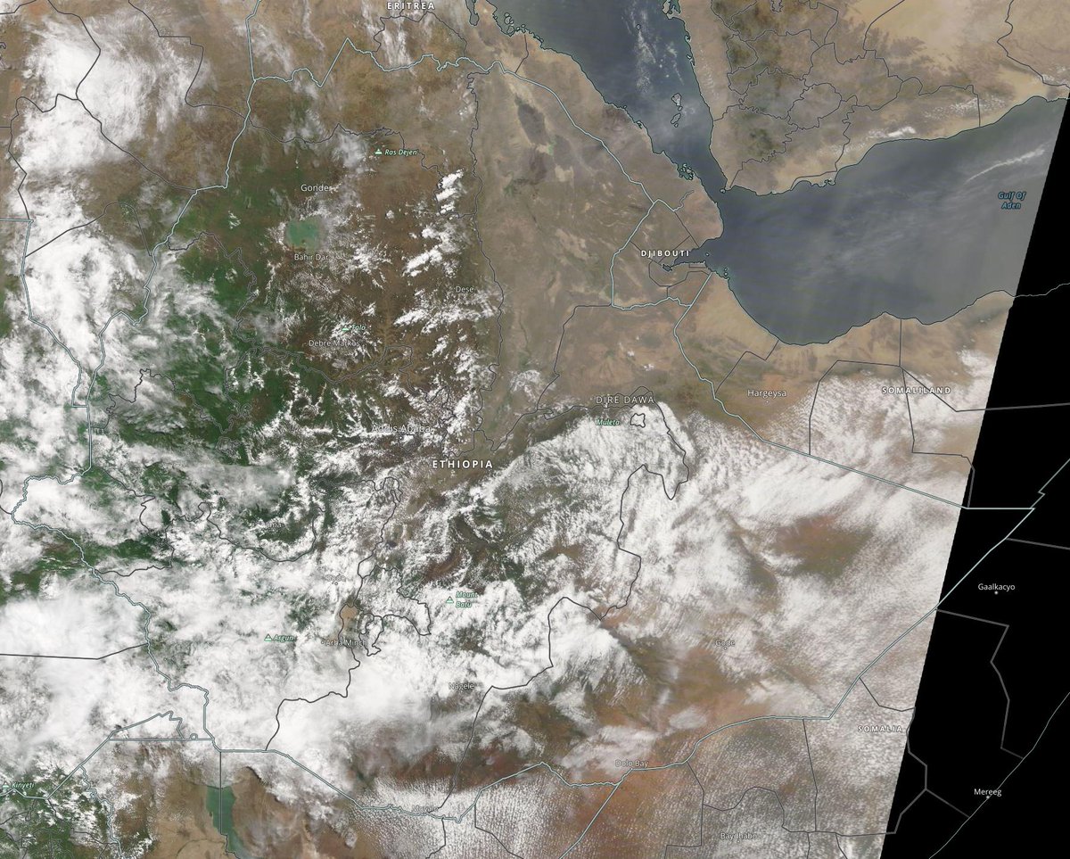
As Ethiopians vote today in their first open contested election here below we can see the rainstorm forming in the morning.
Today's #NorthAfrica, #HornOfAfrica and #MiddleEast rainfall forecasts follow.
Today's #NorthAfrica, #HornOfAfrica and #MiddleEast rainfall forecasts follow.
In the big picture today we can see storms over Europe top left and monsoon storms over South East Asia bottom left, as well as yet another day of #ArabianStorms beginning on the Red Sea.
The monsoon storms over SEA provide the moisture which powers the rains over Ethiopia.
The monsoon storms over SEA provide the moisture which powers the rains over Ethiopia.

In this satellite image from this morning we can see visible traces of the water arriving across the Indian Ocean. 

As for Ethiopia itself here is today's @Nasa Modis imagery which provides a split view, which is perhaps appropriate as the country votes, with the futures of 114 million people riding on the result helping to bring the nation together. 

And it seems we now have access (thanks @weathermodels_ to the 16-day GFS forecast as well as the 12-day KMA forecast, providing a longer view forward.
The models are now mostly in agreement about significant levels of rainfall in Northern Mali in coming fortnight.

The models are now mostly in agreement about significant levels of rainfall in Northern Mali in coming fortnight.


These three images also @NASA Modis show cross sections, east to west over the Indian Ocean where the trade-winds are carrying moisture to fuel not just the HoA monsoon, which runs to September, but the entire West Africa Monsoon. 


10-Day rainfall (+1 12-day) forecasts for June 21st, Election day/Solstice for the #HornOfAfrica including, #Somalia, #Somaliland, #Djibouti, #Ethiopia and parts of #Sudan and #SouthSudan
These are the #Abbay rains which will fill the #GERD.


These are the #Abbay rains which will fill the #GERD.


48 hour forecasts for June 21st (today and tomorrow) for the #HornOfAfrica. Including #Somalia, #Somaliland, #Djibouti, #Ethiopia and parts of #Sudan and #SouthSudan.
#GERD


#GERD


This gif shows the beginning of today's #ArabianStorms up to 2pm today local time.
And here we see a wider view showing the water leaving India, moving across the Arabian Sea and arriving in Yemen and the Horn.
10-Day June Solstice, accumulated rain forecasts for the #MiddleEast from the GFS, ECMWF, CMC & KMA weather models.
#ArabianStorms
#KSA #Yemen #Oman #Jordan #Sudan #Iran #Syria #GERD #Sudan #DesertRain
الله أعلم


#ArabianStorms
#KSA #Yemen #Oman #Jordan #Sudan #Iran #Syria #GERD #Sudan #DesertRain
الله أعلم


48 Hour Solstice (today and tomorrow), accumulated rain forecasts for the #MiddleEast from the GFS, CMC & KMA weather models.
#ArabianStorms
#KSA #Yemen #Oman #Jordan #Sudan #Iran #Syria #GERD #Sudan #DesertRain
الله أعلم


#ArabianStorms
#KSA #Yemen #Oman #Jordan #Sudan #Iran #Syria #GERD #Sudan #DesertRain
الله أعلم


And finally, June 21st, Solstice, 16-day (GFS) and 12-day (KMA) accumulated rainfall forecasts for the Middle East.
Rainfall on the Arabian Peninsula looks set to continue.
[Note: three of the four models now show rainfall on the Southern Yemen Coast.]
الله أعلم

Rainfall on the Arabian Peninsula looks set to continue.
[Note: three of the four models now show rainfall on the Southern Yemen Coast.]
الله أعلم


• • •
Missing some Tweet in this thread? You can try to
force a refresh


