The next two weeks promise to bring astonishing weather to both sides of the Red Sea & across the Sahara. In this weather bulletin I will explain what the models are forecasting.
Today's #NorthAfrica #HornOfAfrica and #MiddleEast rainfall forecasts follow.
Today's #NorthAfrica #HornOfAfrica and #MiddleEast rainfall forecasts follow.

In the image above we see part of Arabia and part of the #NileBasin storms - those which feed the Blue Nile/Abbay and the Tekeze basins the source of most of the Nile's flow.
Below we see:
1. All Nile Basin rainfall as of this evening
2. All of this evenings #ArabianStorms
Below we see:
1. All Nile Basin rainfall as of this evening
2. All of this evenings #ArabianStorms


The rainfall we see on both sides of the Red Sea comes mostly from the same source - the monsoon over the Arabian Sea, India and South East Asia.
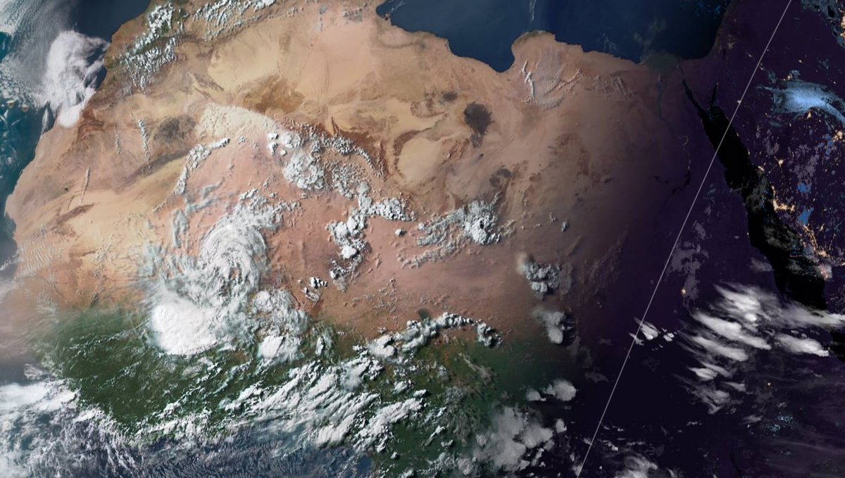
A satellite image from this morning shows what we currently think to be the cradle of humanity. Where we all come from.
A satellite image from this morning shows what we currently think to be the cradle of humanity. Where we all come from.

2 images showing the source of the lifegiving blessing, rain, that sustains life in this most precious area for our shared human history.
Convective (thunder) storms reach great heights delivering sea water sea to the jet winds at 10-15kms high.
Convective (thunder) storms reach great heights delivering sea water sea to the jet winds at 10-15kms high.


Science teaches us that this is the miracle that created the conditions that sustained human evolution over the last 8 million years.
This process is the gift of God through which all of human kind was birthed and nurtured us as we learned to walk, think and believe.
This process is the gift of God through which all of human kind was birthed and nurtured us as we learned to walk, think and believe.
As the atmosphere warms its capacity to carry water increases. In 2021 and with global warming having already increased temperatures by over 1.3 degrees, the intensity of monsoon rains currently provides some of the most obvious evidence of change.
Forecasts for the next 2 weeks show some unusual weather which will likely point to that change in a spectacular fashion.
Today's big picture shows the early stages of significant rains in two places, the Western Sahara and the Arabian Peninsula.
Today's big picture shows the early stages of significant rains in two places, the Western Sahara and the Arabian Peninsula.

This animation shows a 360 hour forecast from the GFS model for the #MiddleEast, #Ethiopia's highlands and the #EastSahara.
It begins with unusually high levels of PWAT over the region. They peak in 10 days time and then decline.
It begins with unusually high levels of PWAT over the region. They peak in 10 days time and then decline.
This shows the same data but showing the variation form climate norms. The blue colour indicates twice as much atmospheric water as compared to the 1981-2010 climate sample.
At the end of this bulletin I will post forecasts showing the consequences from several weather models, all of which are in broad agreement.
But first we turn to #DesertRain in the Western Sahara. Below we see Mali Chad and Niger this morning as photographed by @NASA Modis.
But first we turn to #DesertRain in the Western Sahara. Below we see Mali Chad and Niger this morning as photographed by @NASA Modis.


Here we have two animations. Which show both unusual rain events on each side.
1. (West - left) Over #Mali and #Mauritania.
2. (East - right) Over #Yemen & #Oman (which spreads north into #SaudiArabia and the #UAE at the end of next week.
1. (West - left) Over #Mali and #Mauritania.
2. (East - right) Over #Yemen & #Oman (which spreads north into #SaudiArabia and the #UAE at the end of next week.
The animation above is from @NOAA's GFS model. This one is from Canada's CMC Model which has proved consistently good at predicting rain in the Middle East in recent months. It is the most #DesertRain friendly of the four main models mostly used in these bulletins.
We now return to the regular content. I.E. Rainfall forecasts for #NorthAfrica #HornOfAfrica (Ethiopia & #GERD) and the #MiddleEast which today will include eyewitness images from the wonderful @Arab_Storms extreme weather twitter account.
Today's 10-Day Rainfall forecasts for North Africa from July 10th through July 21st.
[NOTE: The first plot from the European @ECMWF is interesting, it is consistently skeptical of their being any significant #DesertRain but even it is in agreement about the coming #ME event.]
[NOTE: The first plot from the European @ECMWF is interesting, it is consistently skeptical of their being any significant #DesertRain but even it is in agreement about the coming #ME event.]


48-hour rainfall forecasts (today and tomorrow from the same four models: the Euro @ECMWF, U.S. @NOAA's GFS, Canada's CMC and the Korean KMA models.


And finally for #NorthAfrica we have the long-range 16-day (GFS) and 12-day (KMA) forecasts - which remain remarkably well aligned.
You will get a better view of the forecast rain over the southern Arabian Peninsula later in the bulletin.
You will get a better view of the forecast rain over the southern Arabian Peninsula later in the bulletin.


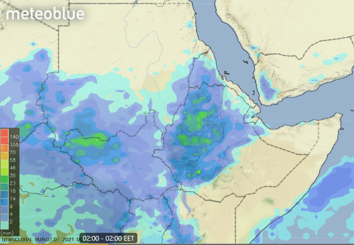
We now turn to the #HornOfAfrica where the strength of storms over northern Ethiopia and Western Sudan was once again remarkable as you can see here.
Today's July 10th 10-day rainfall forecasts for #Ethiopia (+1 12-day from KMA) and the #HornOfAfrica including #Somalia, #Somaliland, eastern parts of #SouthSudan, south eastern parts of Sudan, #Djbouti and #Eritrea.
The purple areas cover the #Abbay and #TekezeAtbara basins.
The purple areas cover the #Abbay and #TekezeAtbara basins.


48 Hour forecasts (today and tomorrow) from the same three models. Rains are now forecast in the west of #Somaliland


A view of today's #ArabianStorms rising over the great Western Desert this afternoon.
This is a slightly higher resolution version of this animation in which it is easier to see the high altitude clouds.
There are two cloud systems moving in quite different directions. A lower layer of clouds is rotates clockwise below.
There are two cloud systems moving in quite different directions. A lower layer of clouds is rotates clockwise below.
July 10th 10-Day accumulated rain forecasts for the #MiddleEast from the GFS, CMC, KMA & ACG weather models.
#ArabianStorms
#KSA #Yemen #Oman #Jordan #Sudan #Iran #Syria #GERD #Sudan #DesertRain #UAE
الله أعلم
#ArabianStorms
#KSA #Yemen #Oman #Jordan #Sudan #Iran #Syria #GERD #Sudan #DesertRain #UAE
الله أعلم


Today we also have two animations showing how this rain event is expected to unfold. This one is from the CMC model.
And this one, nearly identical is from the GFS. As you can see the rains are forecast to fall fairly consistently over this area over the coming132 hours (5.5 days).
Note: Rain is forecast for beyond this period, also rain intensity forecasts have not been great in this area.
Note: Rain is forecast for beyond this period, also rain intensity forecasts have not been great in this area.
48 Hour July 10th (today and tomorrow), accumulated rain forecasts for the #MiddleEast from the GFS, CMC, KMA and ACG weather models.
#ArabianStorms
#KSA #Yemen #Oman #Jordan #Sudan #Iran #Syria #GERD #Sudan #DesertRain
الله أعلم
#ArabianStorms
#KSA #Yemen #Oman #Jordan #Sudan #Iran #Syria #GERD #Sudan #DesertRain
الله أعلم


And finally we have today's long-range #MiddleEast July 10th rainfall forecasts.
The16-day GFS & GEFS models, the 12 day KMA and the 15 day EPS (Euro ensemble) model forecasts.
These have changed from previous forecasts with only GFS forecasting rain in the UAE now.
The16-day GFS & GEFS models, the 12 day KMA and the 15 day EPS (Euro ensemble) model forecasts.
These have changed from previous forecasts with only GFS forecasting rain in the UAE now.


I will look a bit closer at the causes. First, our North Western Hemisphere zero hour simulation data (i.e. now) from the GFS.
1. Precipitable water PWAT anomaly
2. PWAT (potential rain + energy)
3. MLSP (Mean Sea Level Pressure)
4. 250Hpa (jet stream winds approx 11kms high)
1. Precipitable water PWAT anomaly
2. PWAT (potential rain + energy)
3. MLSP (Mean Sea Level Pressure)
4. 250Hpa (jet stream winds approx 11kms high)


Ok. So what's causing this burst of #DesertRain on the southern end of the Arabian Peninsula.
As noted earlier its caused by a burst in Monsoon activity. Here we see the latest 168 hours of data. And notably this is now occurring faster than originally anticipated.
As noted earlier its caused by a burst in Monsoon activity. Here we see the latest 168 hours of data. And notably this is now occurring faster than originally anticipated.
Here's another way of looking at this, and from here we can see that its not just areas to the west that are being effected by this monsoon burst. Pakistan, Xinyang province, Tibet and China are also significantly effected by this.
Another view - again 168 hours - of the simulated PWAT (atmospheric water) anomaly shows us significant amounts of moisture is flowing north east over the Himalayas into Tibet. This water joins up with flows coming north over Myanmar bringing the rain to China.
This MLSP plot animation (168 hours) provides a useful clue, low pressure over the Himalayas deapens signiifcantly during this event. Possibly a symptom of that burst of moisture crossing over at the beginning of the period.
This animation (posted above) ends at 168 hours. And the Western monsoon explosion only explains the first part of what is happening here, because it stops.
Yet as you will soon see the models expect this to continue.
Yet as you will soon see the models expect this to continue.
https://twitter.com/althecat/status/1413904793937002496?s=20
Beyond 180 hours model predictions are subject to significant error. But they remain useful as a guide to understanding what is going on.
And in this case the answer is interesting. Here we zoom out from the plot above to see the next 180 hours it greater context.
And in this case the answer is interesting. Here we zoom out from the plot above to see the next 180 hours it greater context.
It's pretty obvious just looking at this that there is an significant amount of water entering the Middle East over Pakistan, moving in the opposite direction to the burst heading into Tibet. And there is also moisture coming south over Iran.
My hunch in terms of the sudden revision of the models is that this is due to #Elsa being a significantly stronger storm than expected, carrying a lot more water from the tropics around the loop and back into Europe & its the arrival of that water that has caused this adjustment
So what happens next:
First you need to take the remainder of this long-range simulation with caution, as at this range it will definitely change. But with that reservation, it is nevertheless interesting. As it shows high levels of water being maintained over the #MiddleEast.
First you need to take the remainder of this long-range simulation with caution, as at this range it will definitely change. But with that reservation, it is nevertheless interesting. As it shows high levels of water being maintained over the #MiddleEast.
And importantly for China and maybe for the Olympics, it also suggests the pattern over the Himalayas which is delivering ongoing massive flows of water (= thunderstorms) to China, will continue.
Presented like this it also looks a bit like a beating heart, this follows the day-night cycle as each frame represents 12 hours.
Also the observant will notice that it also contains two typhoons, the second of which looks rather dangerous.
/ENDS
@Threadreaderapp unroll
Also the observant will notice that it also contains two typhoons, the second of which looks rather dangerous.
/ENDS
@Threadreaderapp unroll
• • •
Missing some Tweet in this thread? You can try to
force a refresh