The full monsoon has now arrived in the #HornOfAfrica. Very intense rain has begun in the Nile Basin and will continue for a week or more.
What will happen in the #MiddleEast is less clear, but it will involve a lot of rain and #ArabianStorms. Today's forecasts follow.
What will happen in the #MiddleEast is less clear, but it will involve a lot of rain and #ArabianStorms. Today's forecasts follow.
This animation shows the flow of rain bearing clouds heading south west across Pakistan which signals the first phase of an event which will intensify significantly over coming days.
This animation shows under wrapped in pulsating bands of storms headed both East and West. It is this intense period of Monsoon activity which is powering the phenomena that his bringing this rain to Yemen, Oman and Saudi Arabia.
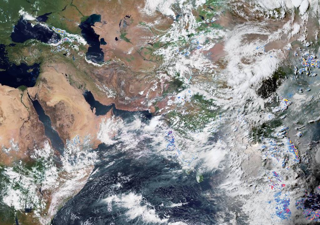
Here we see a different view of the flow of moisture, this time looking down over the Arabian Sea this morning through to around 2pm local time.
And here the Horn of Africa as the south westerly driven rain clouds arrive.
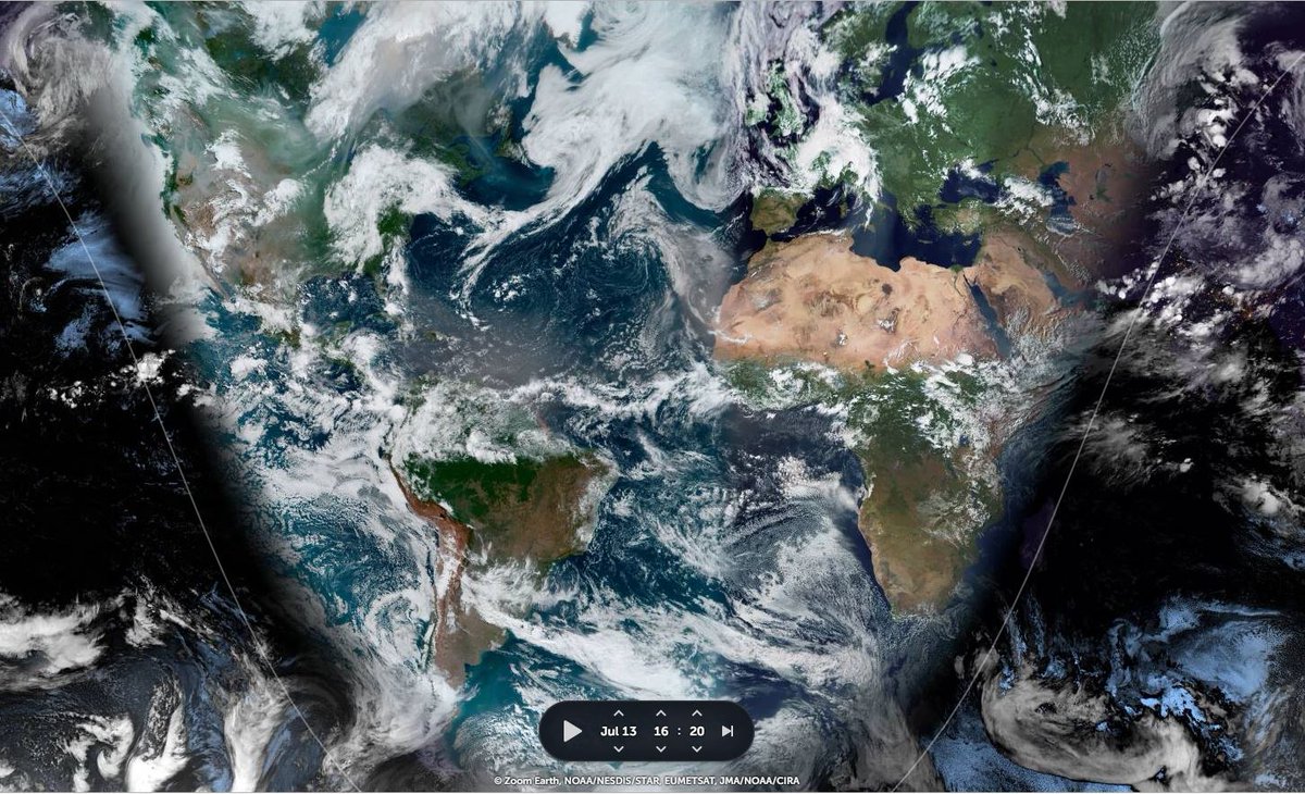
This image is from this evening. When the lower angle of the sun allows us to see more of the texture of the cloud masses which combined (ME+HOA) cover an area roughly the size of Australia, including all the basins of the Nile. 

Today's big picture zooms out to a view which takes in the East, from where the moisture is coming, and to where an equally startling set of airborn water jets is heading north east from Tibet into mainland China.
I may provide commentary and animated graphics later in the bulletin providing a view of what to expect in coming days. But for now will return to the regular content in this daily bulletin, namely, rainfall forecasts for #NorthAfrica #HOA and #ME.
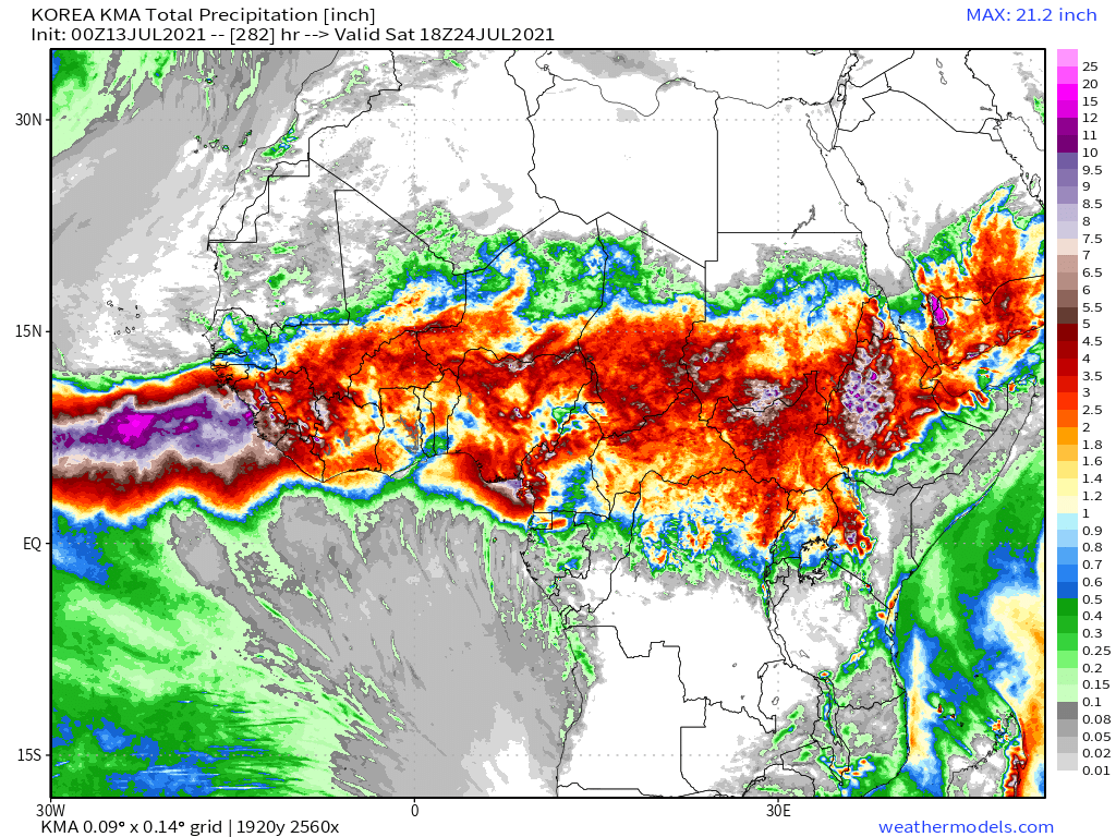
Today's 10-Day Rainfall forecasts for North Africa from July 13th through July 24th.
[All four models forecasts for #ArabianStorms have increased.]
[All four models forecasts for #ArabianStorms have increased.]


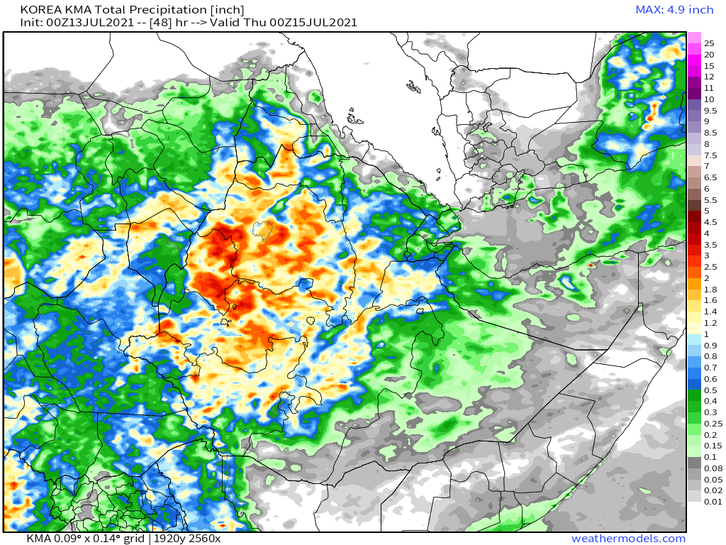
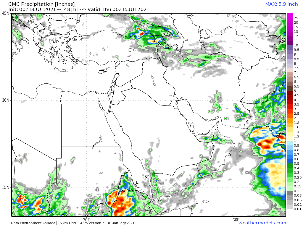
48-hour rainfall forecasts (today and tomorrow from the same four models: the European @ECMWF, U.S. @NOAA's GFS, Canada's CMC and the Korean KMA models.
So far there is more cloud than rain over the ME and this is also what the forecasts seem to expect, at least till tomorrow.
So far there is more cloud than rain over the ME and this is also what the forecasts seem to expect, at least till tomorrow.


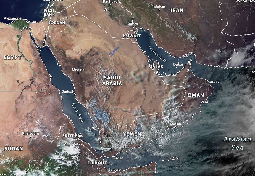
These two Satellite based live rain images show the picture from around midday today, when the big rain storms over the Arabian Sea were just beginning to arrive.

And finally for #NorthAfrica we have the long-range 16-day (GFS) and 12-day (KMA) forecasts - which remain remarkably well aligned.
We will have a better view of forecast rain over the southern Arabian Peninsula later in the bulletin.
We will have a better view of forecast rain over the southern Arabian Peninsula later in the bulletin.

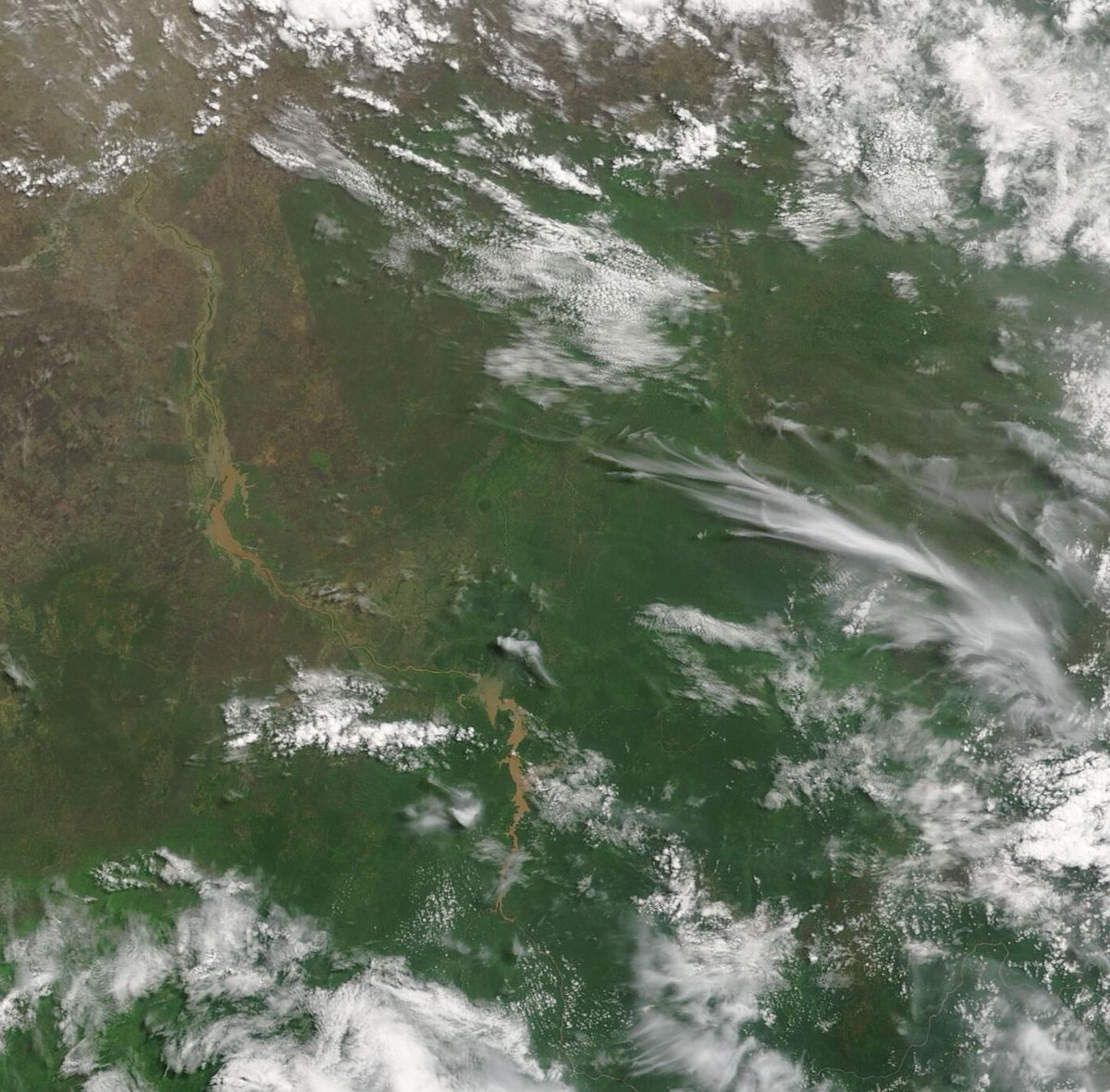
In these two images we see the #GERD lake today (on the left) and on July 28 2020, shortly after the first filling on the right. And as you can see the visible differences are fairly minor at first glance. However they are apparent if you look closely.
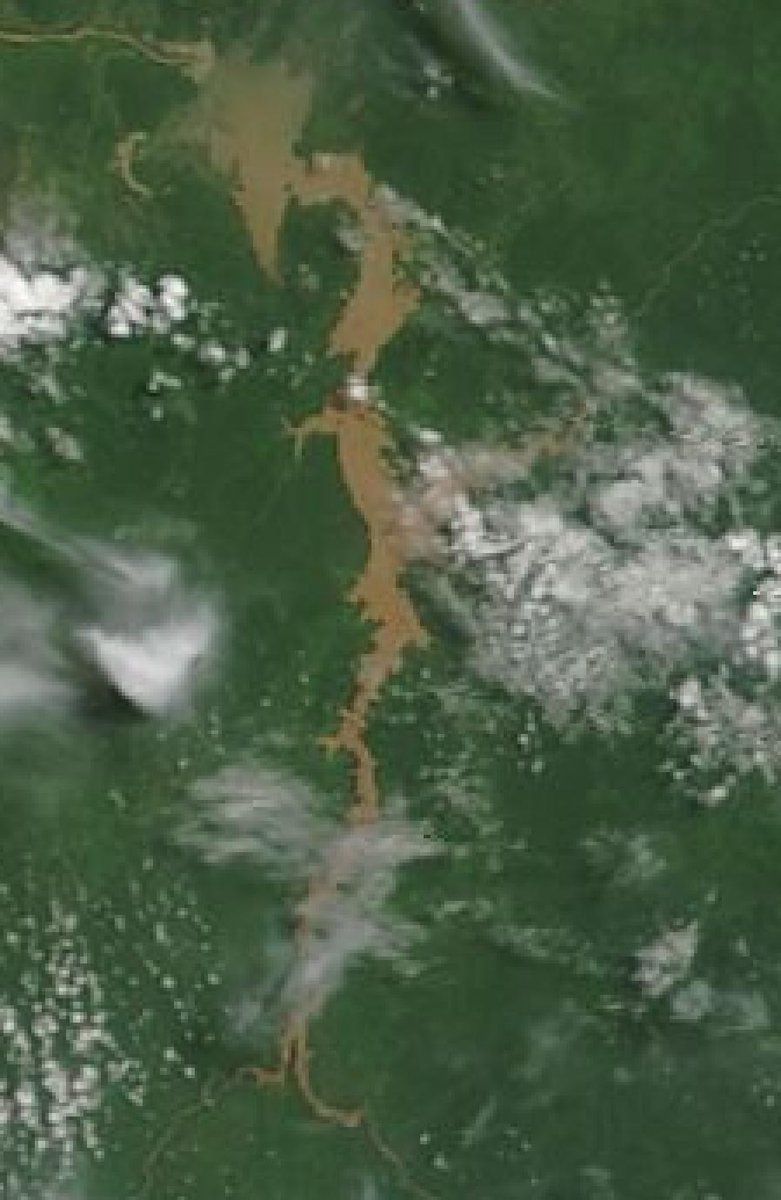

Zooming out we have a superb view of the Blue Nile / Abbay river, which appears to be in flood. Top left you can see the Rosieres dam in Sudan, with the Blue Nile river heading north and the irrigated, cultivated land of Sudan around it.
Today's July 13th 10-day rainfall forecasts for #Ethiopia (+1 12-day from KMA) and the #HornOfAfrica including #Somalia, #Somaliland, eastern parts of #SouthSudan, south eastern parts of Sudan, #Djbouti and #Eritrea.
The purple areas cover the #Abbay and #TekezeAtbara basins.
The purple areas cover the #Abbay and #TekezeAtbara basins.


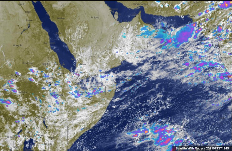
48 Hour forecasts (today and tomorrow) from the same three models. Rains are now forecast in the west of #Somaliland, which iis confirmed by today's satellite imagery from the area.


Here's a closeup view of today's #ArabianStorms, the first day of an event which is unlike anything seen in the area since 1995 according to my local sources.
We have a great set of @Arab_Storms live reports of flooding and storms today. The first two from Sudan.
https://twitter.com/Arab_Storms/status/1414997278583099392?s=20
... [Courtesy of @Arab_Storms]
https://twitter.com/Arab_Storms/status/1414998336009027584?s=20
And from across the Arabian Sea in Rajastan in Nothern India. [Courtesy of @Arab_Storms]
https://twitter.com/Arab_Storms/status/1414995776158113799?s=20
#Oman was very much in the eye of this extended period of storms today. [Courtesy of @Arab_Storms]
https://twitter.com/Arab_Storms/status/1414994004861726734?s=20
As was #Yemen. [Courtesy of @Arab_Storms]
https://twitter.com/Arab_Storms/status/1414899142124507139?s=20
I would very much encourage my followers in #Ethiopia, #Somaliland, and #Eritrea to consider posting their own images of these coming storms. It would be particularly great to receive some eyewitness videos of the storms in the Ethiopian Highlands in the land of the #Amhara.
July 13th 10-Day accumulated rain forecasts for the #MiddleEast from the GFS, CMC, KMA & ACG weather models.
#ArabianStorms
#KSA #Yemen #Oman #Jordan #Sudan #Iran #Syria #GERD #Sudan #DesertRain #UAE
الله أعلم
#ArabianStorms
#KSA #Yemen #Oman #Jordan #Sudan #Iran #Syria #GERD #Sudan #DesertRain #UAE
الله أعلم


48 Hour July 13th (today and tomorrow), accumulated rain forecasts for the #MiddleEast from the GFS, CMC, KMA and ACG weather models.
#ArabianStorms
#KSA #Yemen #Oman #Jordan #Sudan #Iran #Syria #GERD #Sudan #DesertRain
الله أعلم
#ArabianStorms
#KSA #Yemen #Oman #Jordan #Sudan #Iran #Syria #GERD #Sudan #DesertRain
الله أعلم


And finally we have today's long-range #MiddleEast July 13th rainfall forecasts.
The16-day GFS & GEFS models, the 12 day KMA and the 15 day EPS (Euro ensemble) model forecasts.
Note that UAE rainfall is back in the frame in all models.
الله أعلم
The16-day GFS & GEFS models, the 12 day KMA and the 15 day EPS (Euro ensemble) model forecasts.
Note that UAE rainfall is back in the frame in all models.
الله أعلم


To conclude here is today's North Western Hemisphere zero hour simulation data (i.e. now) from the GFS.
1. PWAT (potential rain + energy)
2. MLSP (Mean Sea Level Pressure)
3. 250Hpa (jet stream winds approx 11kms high)
4. Precipitable water PWAT anomaly
1. PWAT (potential rain + energy)
2. MLSP (Mean Sea Level Pressure)
3. 250Hpa (jet stream winds approx 11kms high)
4. Precipitable water PWAT anomaly


Ok so now for the updated model predictions. First up here is a PWAT (Precipitable Water - GFS 16-day) animation for Eurasia, including a typhoon.
This shows this is a monsoon burst, not a long term pattern. It intensifies, spreads west and then retreats,
This shows this is a monsoon burst, not a long term pattern. It intensifies, spreads west and then retreats,
Its also noticeable that during this burst the Eurasia continent becomes for a while almost completely covered in significant levels of PWAT.
PWAT anomaly (here) provides us a different way of looking at the same data, comparing it with the norm.
PWAT anomaly (here) provides us a different way of looking at the same data, comparing it with the norm.
It is noticeable in this latest model run that the quantity of forecast PWAT over the Middle East has increased with a burst of tropical level moisture over Sudan and Egypt.
This starts on Sunday and runs for three days. At this range though this is not a reliable prediction.
This starts on Sunday and runs for three days. At this range though this is not a reliable prediction.
That said the trend is relevant, as it indicates that the GFS model is expecting more intensification than it was previously. Here's the CMC model version - which is very similar, but at higher resolution.
It is astonishing how much water is shown in all of these simulations.
It is astonishing how much water is shown in all of these simulations.
The CMC's higher resolution leads to greater subtlety in the data as you can see here in their rainfall forecast. It appears it is expecting more of the airborn water to cross Sudan (the arch over the Egypt border). And this in turn leads to more rain further west.
Here's the CMC 10-day accumulating rain forecast for #NorthAfrica as a whole (including parts of the #MiddleEast. It shows rain across all of the Sahara up to the 20th parallel. 5 Degrees further north than normal. And deep into the Sahara desert.
This is a lot of #DesertRain
This is a lot of #DesertRain
This CMC #NorthAfrica PWAT animation again illustrates the correlation between PWAT and forecast rain.
There are moments in this plot in which there is barely any dry air at all over the great Sahara Desert.
And if you are wondering, this is indeed not-at-all -normal.
There are moments in this plot in which there is barely any dry air at all over the great Sahara Desert.
And if you are wondering, this is indeed not-at-all -normal.
The final two animations today zoom our still further. This time we have the GFS model and it is confined to a more realistic 120 hour (5-day) time frame.
It allows you to see how the European water processes interact both with the #WestAfricaMonsoon and the #MiddleEast.
It allows you to see how the European water processes interact both with the #WestAfricaMonsoon and the #MiddleEast.
And here we see the PWAT anomaly version of the same plot which highlights the unusual features.
In this ^^ animation you can see water moving south from Europe over the Sahara and into the Middle East.
My current working hypothesis in terms of the reasons for all this is that high levels of water are creating inertia, via a traffic jam effect in the northern hemisphere.
My current working hypothesis in terms of the reasons for all this is that high levels of water are creating inertia, via a traffic jam effect in the northern hemisphere.
This in turn is making water flow in different and unusual directions, and in the case of this event we have two unusual sets of inputs to Western Eurasia. The remnants of #Elsa coming into Europe, and a monsoon boost to the East over India and and SEA.
Squeezed from both sides the water has nowhere else to go except into the place with least resistance, which is the Sahara.
We live in interesting times indeed.
/ENDS
@Threadreaderapp Unroll
We live in interesting times indeed.
/ENDS
@Threadreaderapp Unroll
P.S. an updated 16-day rainfall forecast for the Indian Subcontinent [for @YeoKrishan]
• • •
Missing some Tweet in this thread? You can try to
force a refresh