It's raining cats and dogs in the highlands northern Ethiopia tonight. Across all of Tigray and south into the #Abbay basin which is busy filling the GERD. The #ArabianMonsoonBlast is getting into gear now but it is far from over.
Today's Rainfall forecasts follow.
Today's Rainfall forecasts follow.
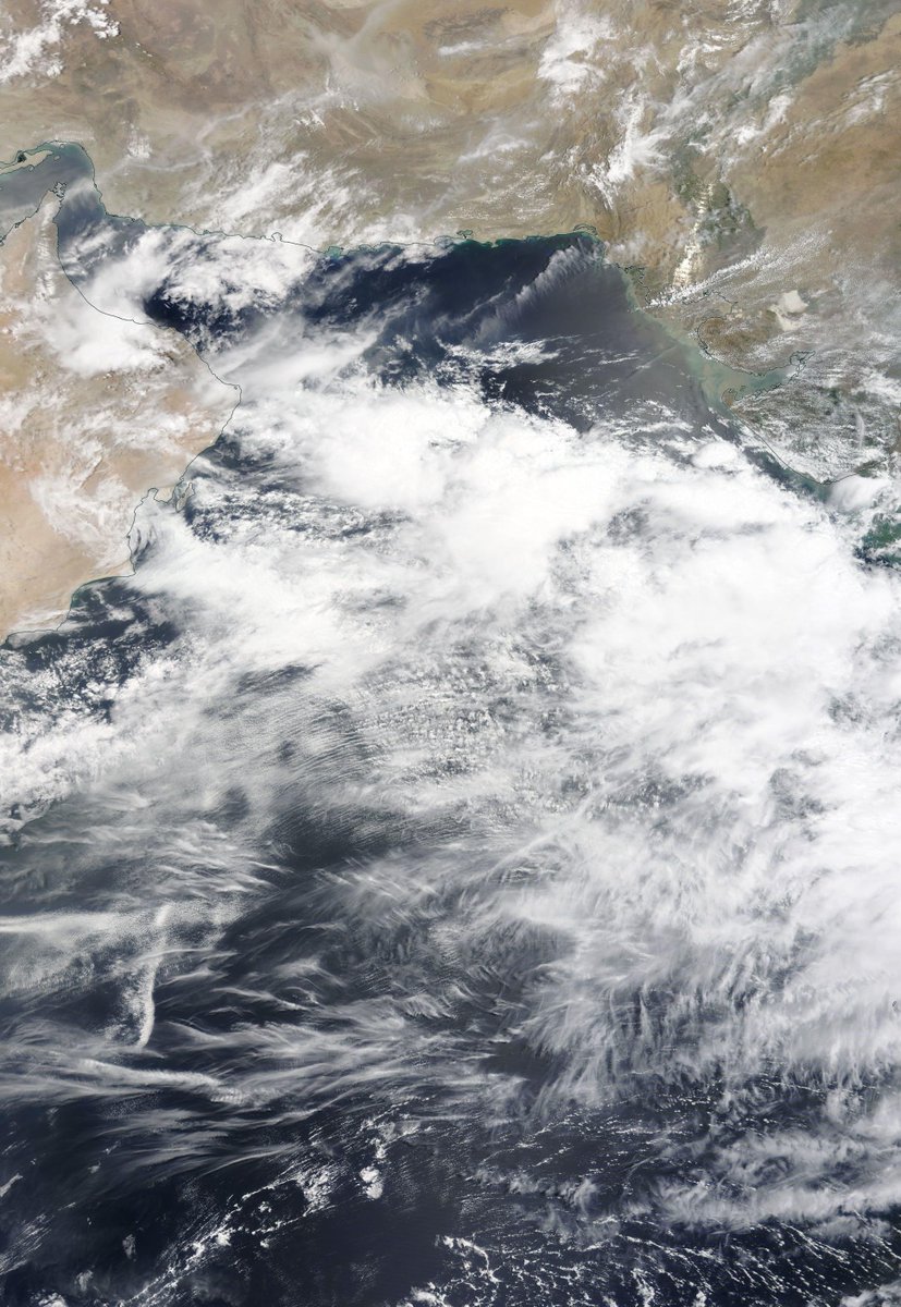
The Bay of Bengal and Arabian Sea are ultimately responsible for all of this and so we begin with a couple of satellite images of them today. I will post another picture of the #GERD as soon as it reveals itself from under the clouds. 

Here's a rainfall map from @Meteoblue which can be followed live at >> meteoblue.com/fr/meteo/curre….
Mekele isn't right under the rain but Aksum and Shire are. Hopefully this will slow down the warriors.
Mekele isn't right under the rain but Aksum and Shire are. Hopefully this will slow down the warriors.


Today's first big picture zooms out to show the #ArabianStorms and those over the #HornOf Africa as the sun set this evening. In the top right you can see New Delhi's lights.
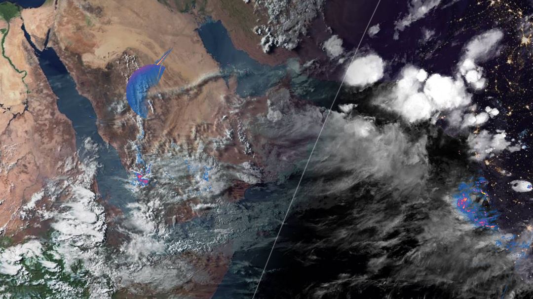
Here we see a view as night fell over the area where a lot of this activity is passing through. Iran, and Pakistan are now forecast to receive significant rains, and clouds seem to be gathering over Afghanistan.
Further South the source of the Nile is also having its own monsoon boost, albeit from a slightly different source.
Here we see the source, in the South Indian Ocean. Mid altitude winds are bringing in moisture heading due west, higher altitude winds from the north East and the low level monsoon winds are bringing moisture across from South East Asia in a big loop.
In terms of how long this is going to last. This 16-day PWAT forecast provides us with some clues. The Monsoon over India appears to be oscillating at high strength and over this period you can see three bursts, the initial one is the only one that heads due west.
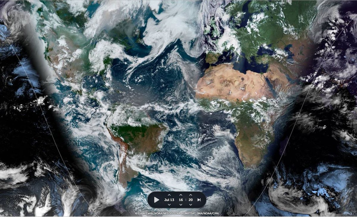
Our second big picture puts all this in context, on the left the Nile, on the right the Indian Monsoon that makes it the extraordinary life-giving river that it is.

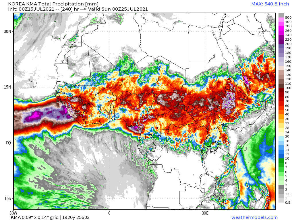
Today's 10-Day Rainfall forecasts for North Africa from July 15th through July 26th.
During this #ArabianMonsoonBursty #ArabianStorms have increased so much that the Arabian Peninsula looks like an extension to the monsoon!
During this #ArabianMonsoonBursty #ArabianStorms have increased so much that the Arabian Peninsula looks like an extension to the monsoon!


48-hour rainfall forecasts (today and tomorrow from our standard four models: the European @ECMWF, U.S. @NOAA's GFS, Canada's CMC and the Korean KMA models. The last, skinniest, one is the ECMWF.


And finally for #NorthAfrica we have the long-range 16-day (GFS) and 12-day (KMA) forecasts - which remain remarkably well aligned.
[NOTE: We will have a better view of forecast rain over the southern Arabian Peninsula later in the bulletin.]
[NOTE: We will have a better view of forecast rain over the southern Arabian Peninsula later in the bulletin.]


As an introduction to the #MiddleEast portion of this bulletin here are three ways to look at what is happening over a 16 day period. This PWAT anomaly graph shows us where unusual amounts of water will be over time.
In this graph (% Accumulated rainfall over normal) the scale doesn't work. because there is normally no rain at all in the blue areas a this time of year.
This version of the data shows excess inches in rain of normal. Note that the Ethiopian Highlands, especially northern parts of it is one of the areas where this is expected to happen.
July 15th 10-Day accumulated rain forecasts for the #MiddleEast from the GFS, CMC, KMA & ACG weather models.
#ArabianStorms
#KSA #Yemen #Oman #Jordan #Sudan #Iran #Syria #GERD #Sudan #DesertRain #UAE
الله أعلم
#ArabianStorms
#KSA #Yemen #Oman #Jordan #Sudan #Iran #Syria #GERD #Sudan #DesertRain #UAE
الله أعلم


N.B: The degree of variation between these simulations is high, and the GFS model (which is behind the plots above) is the least bullish of the rainfall forecasts.
In addition, so far this year all models have tended to under-estimate rain over the Arabian Peninsula.
In addition, so far this year all models have tended to under-estimate rain over the Arabian Peninsula.
48 Hour July 15th (today and tomorrow), accumulated rain forecasts for the #MiddleEast from the GFS, CMC, KMA and ECMWF weather models.
#ArabianStorms
#KSA #Yemen #Oman #Jordan #Sudan #Iran #Syria #GERD #Sudan #DesertRain
الله أعلم
#ArabianStorms
#KSA #Yemen #Oman #Jordan #Sudan #Iran #Syria #GERD #Sudan #DesertRain
الله أعلم


And finally we have today's long-range #MiddleEast July 14th rainfall forecasts.
The16-day GFS & GEFS models, the 12 day KMA and the 15 day EPS (Euro ensemble) model forecasts.
الله أعلم
The16-day GFS & GEFS models, the 12 day KMA and the 15 day EPS (Euro ensemble) model forecasts.
الله أعلم


Our first @Arab_Storms eyewitness video today comes from the Empty Quarter Desert in the south of the Arabian Peninsula and shows a classic super-cell thunderstorm.
https://twitter.com/Arab_Storms/status/1415671297074294793?s=20
In this tweet we see a flooded town in Germany south of Bonn which has claimed at least 44 lives with dozens of people still missing. [Reuters report: reuters.com/business/envir…]
https://twitter.com/Arab_Storms/status/1415653740997009410?s=20
There has also been extreme flooding today in Belgium and the Netherlands >> CNN Report edition.cnn.com/videos/weather… [Tweet courtesy of @Arab_Storms]
https://twitter.com/Arab_Storms/status/1415405025459773440?s=20
& here from the Netherlands >>
https://twitter.com/Arab_Storms/status/1415577197440643072?s=20
Meanwhile in Oman which is at the heart of much of the #ArabianMonsoonBurst here we see a large reservoir dam spilling.
https://twitter.com/Arab_Storms/status/1415576006186831877?s=20
Here is today's North Western Hemisphere zero hour simulation data (i.e. now) from the GFS.
4. Precipitable water PWAT anomaly
1. 250Hpa (jet stream winds approx 11kms high)
2. MLSP (Mean Sea Level Pressure)
3. PWAT (potential rain + energy)
4. Precipitable water PWAT anomaly
4. Precipitable water PWAT anomaly
1. 250Hpa (jet stream winds approx 11kms high)
2. MLSP (Mean Sea Level Pressure)
3. PWAT (potential rain + energy)
4. Precipitable water PWAT anomaly


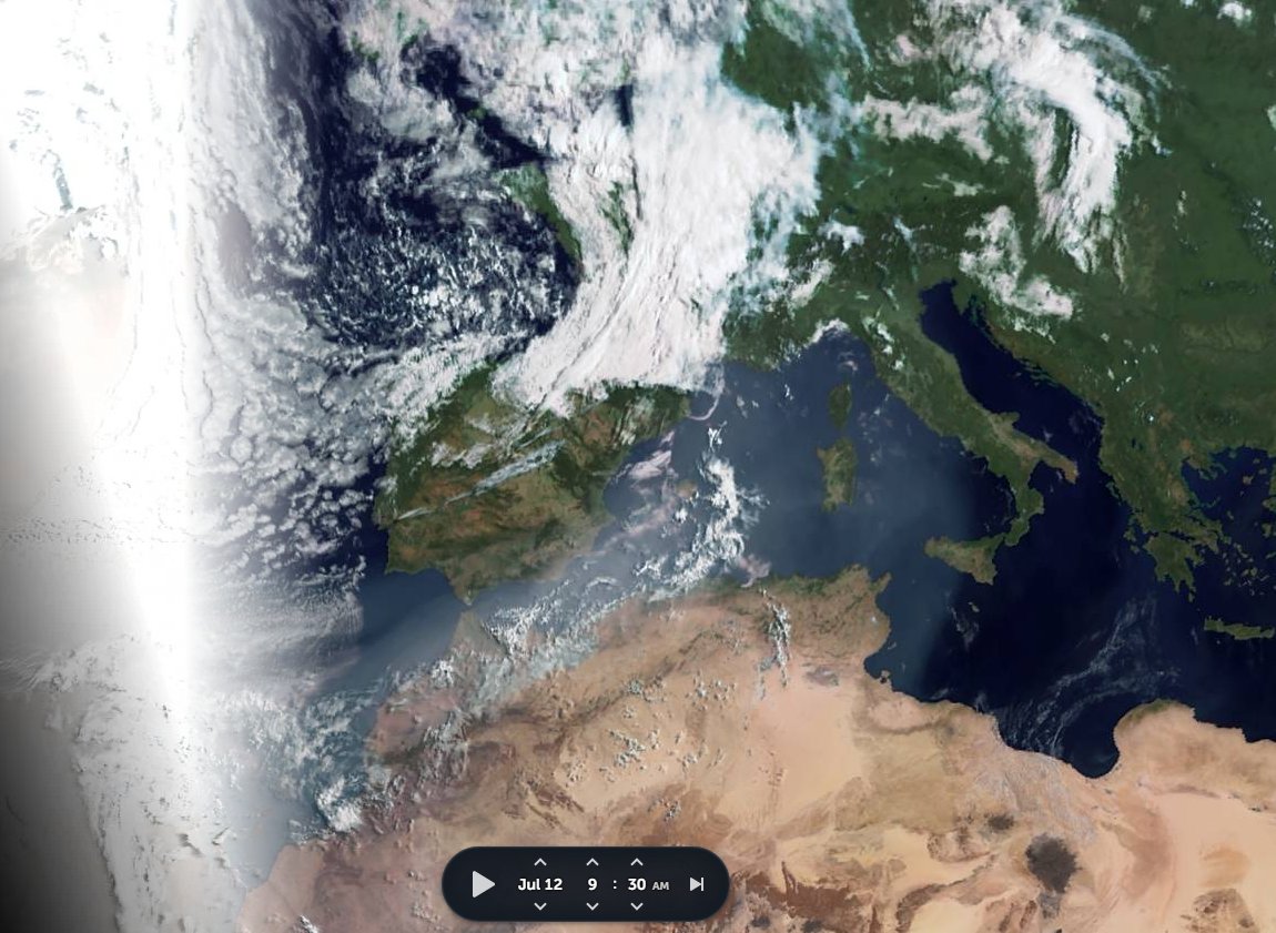
Here we see the storm in Europe today. This low pressure system has been in place for several days.
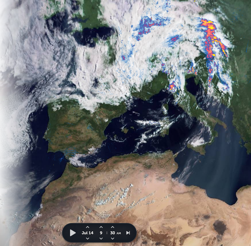
That was in the morning. And this is it now. It does not appear to be going away. Or even moving at the moment.
In the large PWAT map of the region from this morning we can see why. The sheer mass of water to the east of western Europe is slowing down the easterly movement of water.

In the PWAT Anomaly Map we can see the degree to which this differs from climatic norms. The MLSP plot shows us that the storm is being held in place on both sides by high pressure areas.
The thunderstorms moving north to the east of the storm on the boundary.
The thunderstorms moving north to the east of the storm on the boundary.


Here we see the forecast for this storm for in the Euro ECMWF model this morning.
1. 00 run for 3pm today
2. 06 run for 3pm tomorrow
3. 06 run for 3pm Saturday
Clearly this storm is not even close to finished.
1. 00 run for 3pm today
2. 06 run for 3pm tomorrow
3. 06 run for 3pm Saturday
Clearly this storm is not even close to finished.


And this (the plume from the bottom left) could be part of the reason this storm is so persistent and causing such high levels of rain.
Here we see.
1 .250HPA jet-stream winds (10-15kms high) as at 12pm today the area in green is the exact trajectory of the plume in the preceding tweet.
2. And mapping that jet-stream to this PWAT map we can see that the water powering this storm is a #WestAfricaWaterPlume
1 .250HPA jet-stream winds (10-15kms high) as at 12pm today the area in green is the exact trajectory of the plume in the preceding tweet.
2. And mapping that jet-stream to this PWAT map we can see that the water powering this storm is a #WestAfricaWaterPlume


We haven't seen many of these for a while as the water has mostly been travelling the opposite direction of late, from Europe southwards over the Sahara.
But we see here it is not forecast to last too long either as it is about to get clobbered by a fast moving Atlantic storm.
But we see here it is not forecast to last too long either as it is about to get clobbered by a fast moving Atlantic storm.
This is a slice of the same ECMWF model over North Africa (90 hours) and we can see that the consequences of the water being displaced over Italy is that it ends up over the Sahara, adding more water to an already raging #WestAfricaMonsoon.
The moral of all of this is I think fairly simple. The active impacts of Climate Change are already upon us.
The storm we saw today had a corollary in June which was much longer lasting, also monsoon powered, it sat over the Black Sea for a very lengthy period.
The storm we saw today had a corollary in June which was much longer lasting, also monsoon powered, it sat over the Black Sea for a very lengthy period.

/ENDS
@threadreaderapp unroll
@threadreaderapp unroll
... threadfix...
https://twitter.com/althecat/status/1415733669394882560?s=20
... Threadfix ...
https://twitter.com/althecat/status/1415727100032585732?s=20
• • •
Missing some Tweet in this thread? You can try to
force a refresh