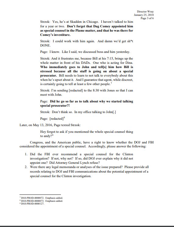
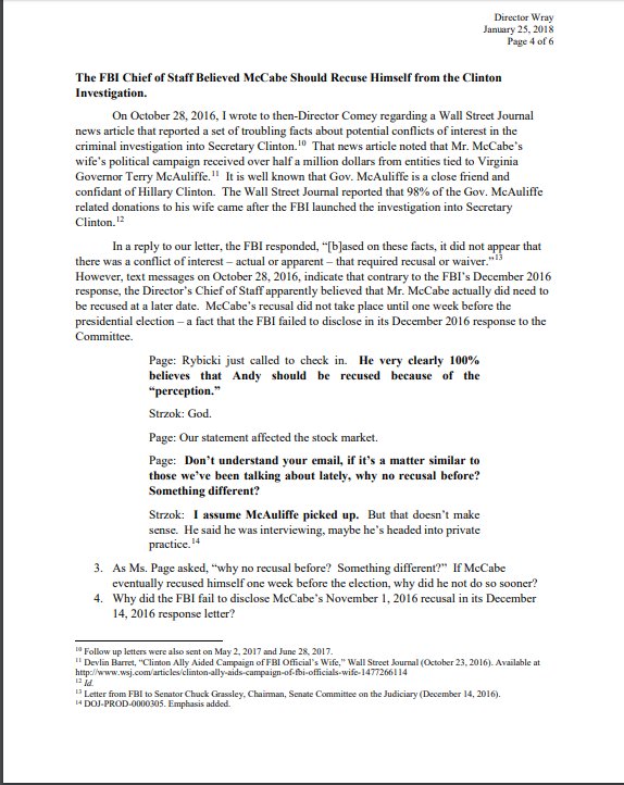
,
66 tweets,
8 min read
Read on Twitter
CU South: The uni sent a letter today re-asking for either some form of Variant 2 design, or going with a 100-yr or 250-yr flood to reduce pooling on CU land, or letting CU build in some of the Open Space-Other land since their Public zoned land will be flooded.
Here's the staff presentation on this: www-static.bouldercolorado.gov/docs/6B_CU_Sou…
Phil Kleiser is reminding folks that there have not been delays yet in the prelim design and annexation processes. If a design is settled on in the next 6 months, that will hold true.
Douglas Sullivan is chatting about engineering. There is a bunch of work going on now that would have to be done regardless of the eventual design of the flood wall / detention.
Maybe up to 9 months, Sullivan says.
Things like groundwater investigations, etc. are being done now.
"It’s a little presumptuous to say we’ve lost time or should have gotten there before," Sullivan says.
"It’s a little presumptuous to say we’ve lost time or should have gotten there before," Sullivan says.
Brockett questions that a bit, bc of the finagling over Variant 1 (remember when they were, like, should we do a sloped detention pond? Or change the protection level:?) boulderbeat.news/2019/02/02/lon…
What would you all have been doing the past 8 months if we had answers on that earlier, Brockett says.
Preliminary design would have started 6 months earlier. So we'd be 6 months ahead.
Preliminary design would have started 6 months earlier. So we'd be 6 months ahead.
Kathleen Bracke is up now to talk about CDOT negotiations. "We've been having conversations with them over a long period of time." Years.
Most recent meeting last week. "I want to say how positive and productive that was," Bracke says.
That meeting resulted in an agreement that Boulder can put its flood wall along the CDOT right-of-way, and underground elements in their right-of-way. That was in question bc they might have wanted to expand U.S. 36.
"That was a big give on behalf of CDOT," Jones says.
CDOT did not feel comfortable with attaching a flow restrictor to its bridge. Nor did they want it "close" to the bridge, Bracke says.
Jones: "Should we just tackle the bridge thing?"
Carlisle makes sure to call it out that was a design element of Variant 2.
Bracke: They didn't refer to the Variant design as a whole.
Carlisle: That was the whole thrust of Variant 2...
Jones: We'll look at that in a minute.
3 more min of staff presentation first.
Bracke: They didn't refer to the Variant design as a whole.
Carlisle: That was the whole thrust of Variant 2...
Jones: We'll look at that in a minute.
3 more min of staff presentation first.
Dan Burke from open space: What we have learned does represent a pretty significant departure from the understanding and assumption that there would be no flood structure on open space lands.
"Latest discussion with CDOT has negated this assumption and put disposal of open space land back on the table."
This was looked at back in 2014, to put a flood structure on open space. Council decided to look at other alternatives to avoid a disposal of land, Burke says. "Option D was selected in part bc it did not require disposal of open space lands."
Reasons to avoid that is bc of the high-quality habitat there. Remnant tall grass prairie, ute lady tresses orchid, preble's jumping mouse, wetlands... etc. Some of the highest-quality land in the state, Burke says.
The city charter dictates how open space land disposal happens.
Carr breaks in to say "this is a little premature."
Carr breaks in to say "this is a little premature."
"I'm surprised we're talking about this," Carr says. "We're a long way away from making a disposal decision." It may not actually be a disposal; the city attorney's office is studying it now.
Carr: The council decides if a disposal is necessary; the open space board decides if it happens.
Council could decide flood mitigation is an open space purpose and therefore doesn't require a disposal of land, Carr explains. (With some help from Jones.)
Back to Burke: We did thoroughly look at this last year. There's a possibility the disposal situation is on the table.
Carlisle: Can we have more clarification around disposal of open space land?
Carr: Decision on open space is a joint decision by council and OSBT. Both agree to do it. Council decides what an open space purpose is.
Carr: Decision on open space is a joint decision by council and OSBT. Both agree to do it. Council decides what an open space purpose is.
"Everybody agreed it is council's perogative to decide what an open space purpose is." The charter says, but there's some ambiguity. "You're the ones who gets to interpret."
Carlisle: I totally disagree with you. That lies with open space board.
Carr: Disposal lies with them. Open space purposes lies with you.
Carlisle: Then we could make up purposes.
Carr: Purposes are in the charter. You get to interpret it.
Carr: Disposal lies with them. Open space purposes lies with you.
Carlisle: Then we could make up purposes.
Carr: Purposes are in the charter. You get to interpret it.
Back to CDOT: Their right-of-way is between 40-50 feet.
Sullivan: "They don’t want the vertical wall in their right-of-way." But they will let the horizontal foundations underground in the right of way, and the caissons that get built into bedrock.
So the floodwall (I think) will be 40-50 feet from 36.
On open space, the permanent impact will be part of the vertical wall itself, which will extend 2-4 feet into it, then the underground foundation and caissons. 1 acre will be permanently impacted; 3-4 temporarily.
On open space, the permanent impact will be part of the vertical wall itself, which will extend 2-4 feet into it, then the underground foundation and caissons. 1 acre will be permanently impacted; 3-4 temporarily.
Out of "thousands of acres" contiguous to this. At least 1,100 in that state natural area alone, Burke says.
So 1 of 1,100 acres permanently impacted.
So 1 of 1,100 acres permanently impacted.
Burke: You can restore (the area) to its natural condition, but not bring it back to wet meadow it is now.
Carlisle wants to hear more.
Carlisle wants to hear more.
Burke: This is new info; we haven't considered it yet.
Jones: What did you think was going to happen? Surely we didn't think we'd build it right next to the highway. Did we think we'd get a better deal than this?
Jones: What did you think was going to happen? Surely we didn't think we'd build it right next to the highway. Did we think we'd get a better deal than this?
Burke: Variants we were considering had no structures on open space.
Jones: Where did you think they would go?
Burke: In CDOT right of way.
Jones: It goes underground 30 feet. That's a lot of their right-of-way.
Jones: Where did you think they would go?
Burke: In CDOT right of way.
Jones: It goes underground 30 feet. That's a lot of their right-of-way.
Carlisle: Those are things I would have hoped we would have found out already.
Are the assumptions we're making now even correct given how off they've been prior to this? We're given a whole new scenario now, again.
Are the assumptions we're making now even correct given how off they've been prior to this? We're given a whole new scenario now, again.
Brockett: If open space board says no, what would we have to do to get flood detention?
Sullivan: We'd have to look at a very, very different configuration. We do flood mitigation in very, very different ways. There was analysis on the west side of 93 at one time.
Sullivan: We'd have to look at a very, very different configuration. We do flood mitigation in very, very different ways. There was analysis on the west side of 93 at one time.
Brockett: In order to get flood detention, we have to have this flood wall?
Sullivan: Yes
Brockett: So we'd have to go back 17 steps.
Sullivan: Yes
Brockett: So we'd have to go back 17 steps.
Flood wall would be 2,6000 feet long.
Now we're talking bridge/flow restrictor/Variant 2.
Sullivan: CDOT made very clear in the meeting they were not OK with any structure attached to the bridge. So it would have to be separated from the bridge. CDOT still has some right-of-way off the bridge, so can it go there? Or does it have to be outside the ROW?
Jones: What I thought I heard is that the right-of-way goes 52 feet out from the bridge. So we'd have to build the wall 52 feet out from the bridge.
Jones: The only reason it matters is it would have to be way back from the bridge, which puts it way back into open space; we'd have to build some kind of cement wall out there and pave the stream bed after that. That's the point I said, that's not going to happen.
That's a key element of Variant 2. "I know we can engineer our way to it, but aesthetically and what we do to open space, that seems to not be an option there."
Bracke: That's my understanding, too.
Sullivan nods.
Jones: Variant 2 isn't on the table; our decision space is variations of Variant 1. We know Variant 1 is the right answer; we need to negotiate within that space.
Sullivan nods.
Jones: Variant 2 isn't on the table; our decision space is variations of Variant 1. We know Variant 1 is the right answer; we need to negotiate within that space.
Weaver: It will be good to get away from discussions over variants. I think of it as different locations of the spillway.
So that's the update; council is going to give staff direction ahead of two more meetings on this: July 16 and Aug. 13. August will be the discussion with CU.
Jones: What are you guys planning to do without us telling you what to do, in terms of narrowing options, etc.?
Kleiser: I think at this point, we're sort of at an impasse.
Kleiser: I think at this point, we're sort of at an impasse.
Yates: CU has made it clear they need 129 acres. So within the design plan (we're not going to call it Variant 1 anymore, Jones says), are there variations that get closer to 129?
Yates: Are there things you can do that still achieves flood mitigation of some sort....
Jones: Of high caliber
Yates: Of the highest caliber we're discussing
Jones: (To staff) Don't answer that, but that's what we want you to work on.
Jones: Of high caliber
Yates: Of the highest caliber we're discussing
Jones: (To staff) Don't answer that, but that's what we want you to work on.
Jones: The way we drew lines on the map is how we ended up with 129 acres; there isn't anything magical about 129. So we might explore drawing lines differently.
Weaver: There was also the 500-yr floodplain.
"We've provided a variety of options in the past. I'm not sure to what extent we'd be revisiting." Says some guy that I don't know who he is.
Jeff somebody.
Brockett: We have gone through some of this before, but discussions with CU did not work out. So we are going back a step, as I understand it. What are the options to get CU what they want within Variant 1? I know we've gone over some of this before, but let's talk over it again.
Jones: "We also got new information about Variant 2, which is it ain't really an option. That also gives new info to CU."
Variant 1 is "where we have to play." Says if everyone's priority is life safety, then that changes the conversation.
Weaver: We can look at how much we're detaining, rather than 100-yr or 500-yr flood events, or anything in between.
Sullivan: It's called a sensitivity analysis. What's the inundation vs. detention. "It's a tradeoff. That's what we're talking about here."
Sullivan: It's called a sensitivity analysis. What's the inundation vs. detention. "It's a tradeoff. That's what we're talking about here."
Carlisle: If CU was really caring about their faculty, staff and students, they'd be building on Grandview Terrace rather than down there. Be a good neighbor, as we have tried to do all along.
"We have been trying to accommodate the university."
Yates: When we arrived at Variant 1, we said we didn't want to build on OSO land?
Weaver: We didn't want to have a major impact.
Yates: If something had to give here, does council still feel that strongly on it? Is it reducing detention or impacts on OSO?
Weaver: We didn't want to have a major impact.
Yates: If something had to give here, does council still feel that strongly on it? Is it reducing detention or impacts on OSO?
Brockett: I would like for options to be on the table at the next discussion; we need to move this forward.
The aforementioned Jeff is Jeff Arthur. He's back, saying they might not have enough time to do all this analysis regarding impacts to open space other.
"This is not something we could bring back in July," Sullivan says.
Brockett: If we don't have options to discuss in July, idk why we're having this meeting?
Yates: A lot of this stuff is redo.
Arthur: It's giving you slides you've already seen.
Jones: I think the thing that's different is CDOT is narrowing our space.
Arthur: It's giving you slides you've already seen.
Jones: I think the thing that's different is CDOT is narrowing our space.
Jones: "We know how important moving forward on flood mitigation (is) and we've always felt that way."
That wraps CU South. @threadreaderapp, please unroll. Gonna start one new thread for board/commission appointments.
That wraps CU South. @threadreaderapp, please unroll. Gonna start one new thread for board/commission appointments.