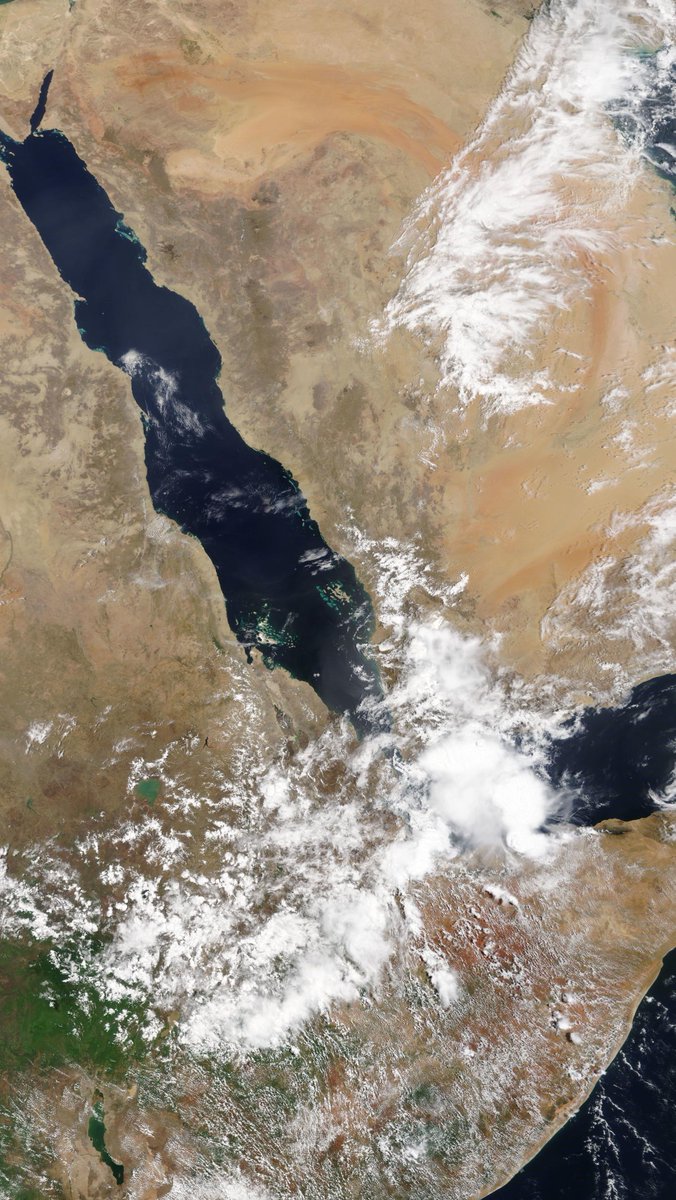
Today is shaping up to be a huge day for thunderstorms across the Arabian Peninsula, #NileBasin and Horn of Africa.

#KSA #SaudiArabia #Yemen #Oman #Iraq #Kuwait

#Ethiopia #Sudan #Eritrea #Somalia #SouthSudan #Uganda

#ArabianStorms #DesertRain
Live weather radar of #ArabianStorms across The Arabian Peninsula. /2
Inside the Grand Mosque in Makkah Muslim pilgrims and the @HolyKaaba. /3
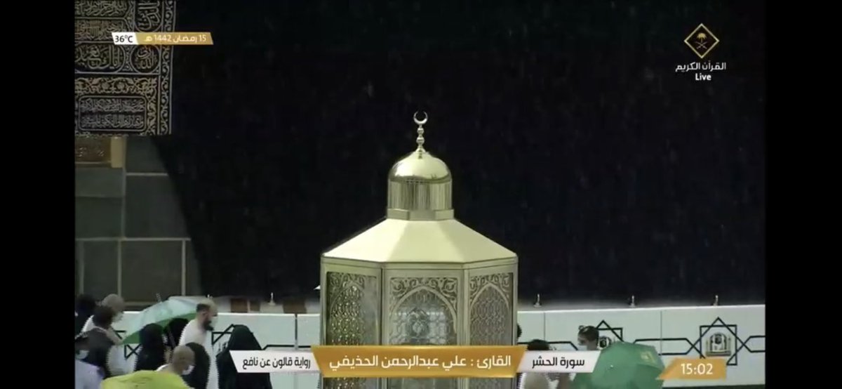
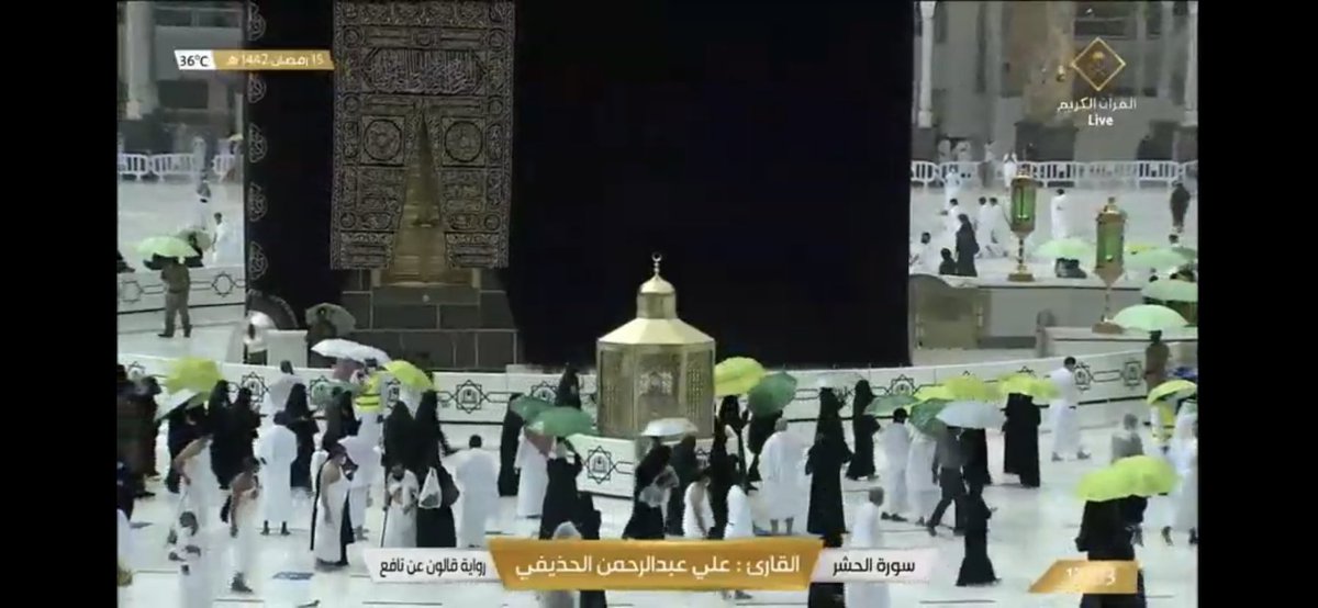
A growing thunderstorm is now situated directly over the holy city of Makkah. /4
As we approach the full heat of the day, today’s #ArabianStorms are developing rapidly across the MIddle East.

Note: The storms in Iran, the Horn of Africa, Yemen and Oman are also delivering #DesertRain but as there is no weather radar they do not show up in blue.
Here is eyewitness footage from inside the Masjid al-Haram Mosque. /6
And another eyewitness video, this time from @saleh_alazzaz, whose wonderful twitter feed includes a lot of very beautiful footage of nature in Saudi Arabia, with a slight emphasis on rain and watercourses.
The @HolyKaaba has a special water pipe at the top of it specially for these occasions.

The sun has come back out now in Mecca as you can see in the final image here.

• • •

Missing some Tweet in this thread? You can try to force a refresh
 

Keep Current with Alastair Thompson

Alastair Thompson Profile picture

Stay in touch and get notified when new unrolls are available from this author!

Read all threads

This Thread may be Removed Anytime!

PDF

Twitter may remove this content at anytime! Save it as PDF for later use!

Try unrolling a thread yourself!

how to unroll video
  1. Follow @ThreadReaderApp to mention us!

  2. From a Twitter thread mention us with a keyword "unroll"
@threadreaderapp unroll

Practice here first or read more on our help page!

More from @althecat

28 Apr
A high resolution taken today by the NASA Modis satellite of the #NileBasin and the #MiddleEast is below.

The day started with storms in the East of the #HornOfAfrica #Yemen and the #KSA and got very busy over the day.

28 April Rain forecasts follow: Image
This first animation shows the beginning of a plume of water coming across the Sahara from the Atlantic. Forecasts indicate water from this plume will arrive in the #MiddleEast and #HoA in 10 days time.
This animation shows the West African Monsoon and the plume of précipitable water making its away across over the Sahara over the coming week.
Read 14 tweets
28 Apr
Dawn breaks on the Middle East and Horn of Africa on 28 April with numerous active storms in play.

#ArabianStorms #Ethiopia
ImageImageImage
Afternoon update 2.45pm: Both #KSA storms have expanded and we now have significant #ArabianStorms in Oman and the #UAE.

Meanwhile in the #Horn of Africa #Ethiopia rainfall to feed the Nile is getting underway, and storms are sparking up along the #Somaliland coast.
Read 5 tweets
28 Apr
Good Morning.... Image
Earlier.... ImageImageImageImage
Image
Read 4 tweets
27 Apr
A major West African Monsoon (WMA) Sahara water transit event has just started. [See animation below).

This thread contains 10 day ECMWF, CMC & ACCESS-G model forecasts of its trajectory & impact on Europe.

The quoted thread addresses #ClimateChange implications.
Here you see the beginning of this event. It is much larger than earlier iterations of the same phenomena. These streams of air-born water are roughly 4000 kms long.
This tweet and the next three contain 10-day forecasts of the trajectory of this hydrological atmospheric phenomena. They forecast precipitable water, the quantity of water which is held in the atmosphere measured in inches.

The first one is from the Euro ECMWF model.
Read 19 tweets
27 Apr
An image of thunderstorm activity in the Ethiopian #Abbay #BlueNile basin this afternoon, also showing significant rains South #Yemen and over most of #Somalia.

Todays, 27th April, accumulated rain forecasts for the #MiddleEast & #HornOfAfrica follow in the thread below.
#ArabianStorms activity was boosted today by moisture flowing from the #Ethiopian monsoon rains in the Ethiopian Highlands, the watershed of the #Abbay #BlueNile catchment.

Below you see a 10-day GFS forecast of accumulated rain over North Africa.
This animation shows the flows of moisture from this morning across the Red Sea. A process which is called the "Southern Gate" by Saudi weather entusiasts. #ArabianStorms #Abbay #BlueNile #GERD
Read 14 tweets
27 Apr
Two views of the intense rain activity across the Middle East and East Africa today from Iran to Uganda.
See also an earlier thread here about rain reaching Mecca.
And another thread from this morning, as the first storm sparked up over the Yemen/Saudi border.
Read 4 tweets

Did Thread Reader help you today?

Support us! We are indie developers!


This site is made by just two indie developers on a laptop doing marketing, support and development! Read more about the story.

Become a Premium Member ($3/month or $30/year) and get exclusive features!

Become Premium

Too expensive? Make a small donation by buying us coffee ($5) or help with server cost ($10)

Donate via Paypal Become our Patreon

Thank you for your support!

Follow Us on Twitter!