A major West African Monsoon (WMA) Sahara water transit event has just started. [See animation below).
This thread contains 10 day ECMWF, CMC & ACCESS-G model forecasts of its trajectory & impact on Europe.
The quoted thread addresses #ClimateChange implications.
This thread contains 10 day ECMWF, CMC & ACCESS-G model forecasts of its trajectory & impact on Europe.
The quoted thread addresses #ClimateChange implications.
https://twitter.com/althecat/status/1382719761210036225
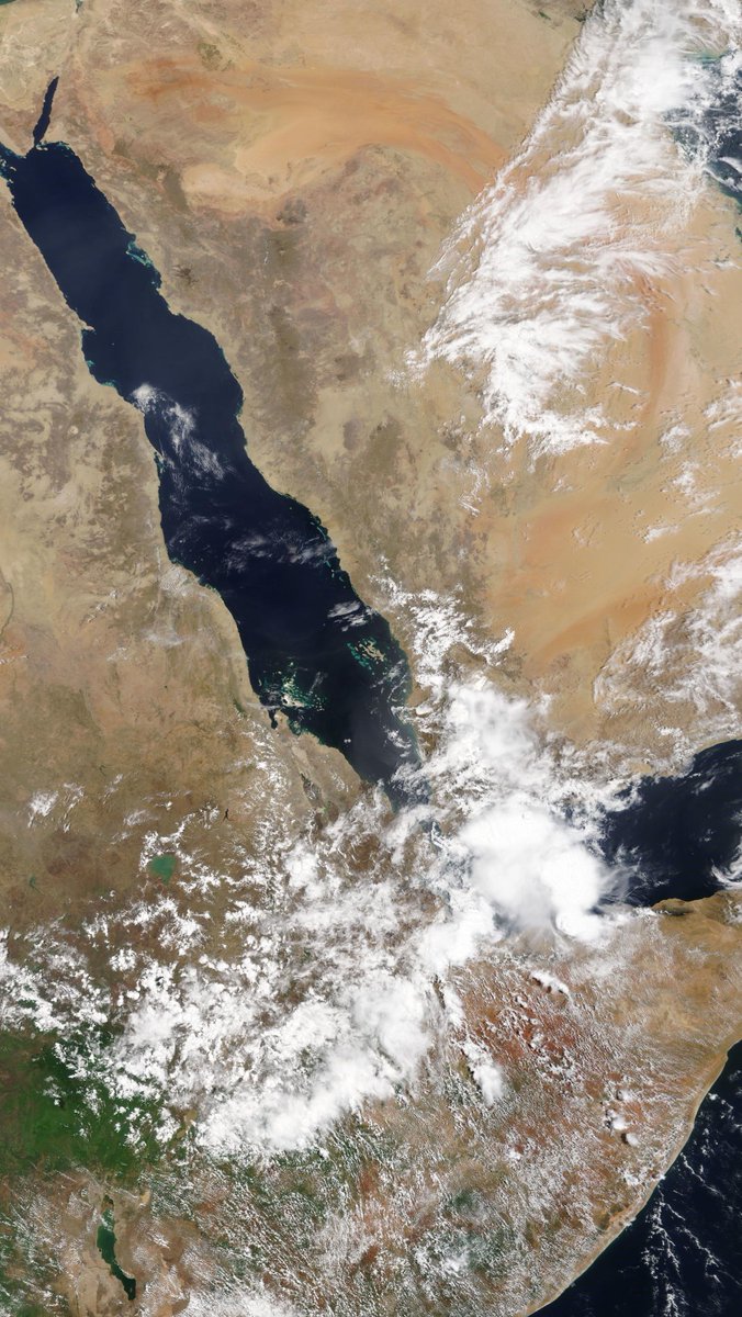
Here you see the beginning of this event. It is much larger than earlier iterations of the same phenomena. These streams of air-born water are roughly 4000 kms long.
This tweet and the next three contain 10-day forecasts of the trajectory of this hydrological atmospheric phenomena. They forecast precipitable water, the quantity of water which is held in the atmosphere measured in inches.
The first one is from the Euro ECMWF model.
The first one is from the Euro ECMWF model.
The ECMWF Model was the slowest to react to this phenomena and remains the least gung-ho about it. As you will see later it is also skeptical about whether it will result in precipitation in the Sahara. I.E. in #DesertRain.
This is the ACCESS-G model from the UK.
This is the ACCESS-G model from the UK.
And the final model I have access to with this parameter (via @weathermodels_ excellent tool) is the Canadian CMC model which is the most bullish of the models on Sahara water transit. The CMC has has also been particularly good at picking what will happen in the Middle East.
The 3 models - all global models - are very strongly in agreement about what is about to happen here. Which leaves me with 3 questions.
1. How much rain will fall in the Sahara?
2. What impact will this have in Europe?
3. What impact will this have in the ME?
1. How much rain will fall in the Sahara?
2. What impact will this have in Europe?
3. What impact will this have in the ME?
Fortunately the wizardry of open science supercomputer weather models means we can actually answer these questions.
1. How much rain will fall in the Sahara?
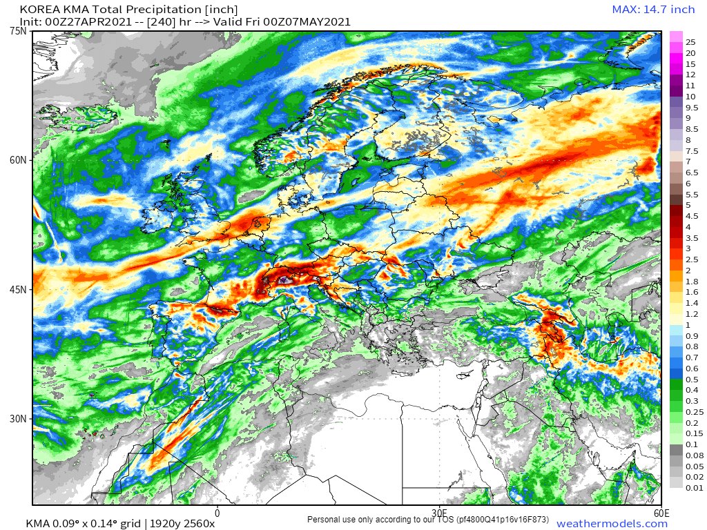
Here are GFS, ECMWF, CMC, KMA (Korea) 10-day rain forecasts.
1. How much rain will fall in the Sahara?
Here are GFS, ECMWF, CMC, KMA (Korea) 10-day rain forecasts.


As you can see there is considerable disagreement.
The Euro model is the most skeptical about #DesertRain and the Korean #KMA embraces the the idea.
This variance is a good thing as over-time it should become clear which model is addressing this the best and why.
The Euro model is the most skeptical about #DesertRain and the Korean #KMA embraces the the idea.
This variance is a good thing as over-time it should become clear which model is addressing this the best and why.
Question 2: What impact will this have in Europe?
Answer 1/2: The first answer uses the same method. How much rain will fall and where? This lets us see, among other things how significant the cascading impact is for forecasting.
Here we see GFS, ECMWF, CMC and KMA
Answer 1/2: The first answer uses the same method. How much rain will fall and where? This lets us see, among other things how significant the cascading impact is for forecasting.
Here we see GFS, ECMWF, CMC and KMA


The biggest outlier here is the ECMWF which has a North Atlantic rain event which none of the others do which is worth investigating further. The last time this happened the ECMWF missed it.
https://twitter.com/althecat/status/1384146361419911174?s=20
The full thread on this (from April 19th - attached) contains a detailed analysis which could be performed on this event also. However it is quite a lot of work.
The event last week had a very large and obvious impact & a fairly good story line.
The event last week had a very large and obvious impact & a fairly good story line.
https://twitter.com/althecat/status/1384065198462443522?s=20
A quick and dirty way to do a similar piece of analysis is to pick a date half way through the period is to look at the variance in précipitable water locations in 7 days time.
Again ECMWF GFS ACCESS-G & CMC
[Note the CMC and ECMWF are expected to be outliers here.]
Again ECMWF GFS ACCESS-G & CMC
[Note the CMC and ECMWF are expected to be outliers here.]


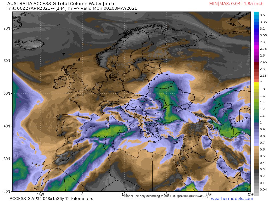

Well that was interesting. Turns out the GFS is the outlier. However that is partly because I do not have access to the North Africa Preciptable water map yet (@RyanMaue at @WeatherModels may be able to help with that - pretty please.).
In terms of the question posed about cascading impact on forecasting though the answer is yes. The difference between the ECMWF forecast and the GFS (the two biggest models) is significant and will be felt in the UK and Russia.
Question 3. What impact will this have in the ME?
This question has already been answered as I have been monitoring this daily since the beginning of April. Here is today's tweet which contains GFS, CMC, KMA and GEFS models.
This question has already been answered as I have been monitoring this daily since the beginning of April. Here is today's tweet which contains GFS, CMC, KMA and GEFS models.
https://twitter.com/althecat/status/1387073663942463496?s=20
I exclude ECMWF from this series because it has been consistently wrong. Until the 19th it was predicting almost no rain over 10 days - it has improved a bit since then, but still consistently underestimates observed Arabian Peninsula precipitation, which to be fair, is unusual.

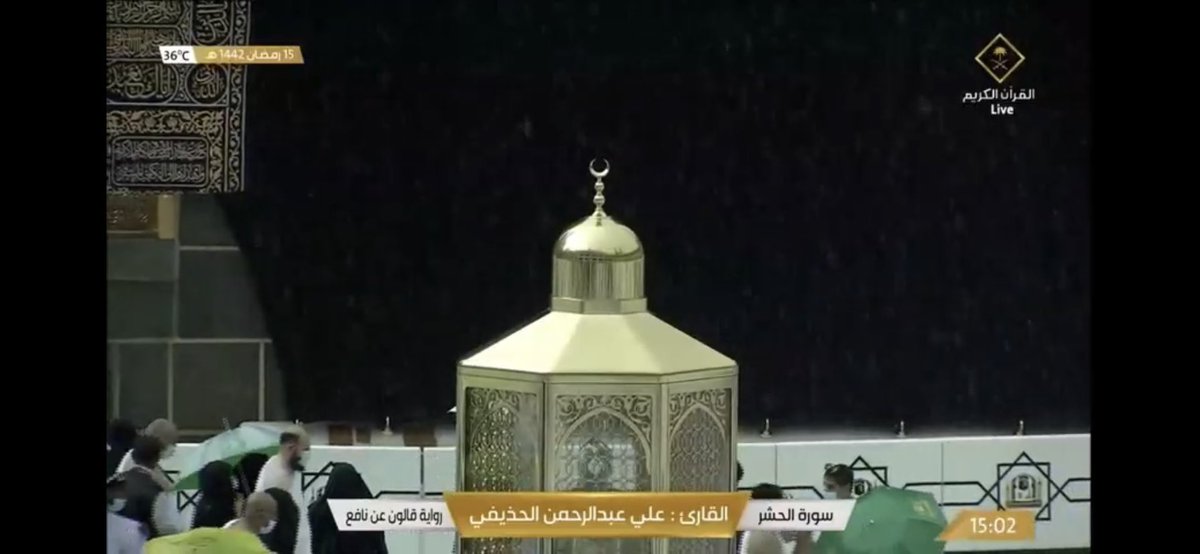
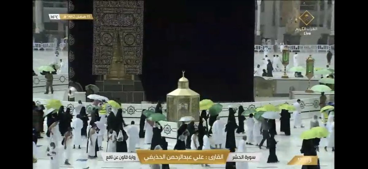
To get a feeling for the scale of the error in @ECMWF rain forecasting error in the Middle East ATM.
The image is the ECMWF forecast for 10 days of rain on the Arabian Peninsula - including today.
Whereas this is just three hours of what actually happened today this evening.
The image is the ECMWF forecast for 10 days of rain on the Arabian Peninsula - including today.
Whereas this is just three hours of what actually happened today this evening.
And on the basis of this, while I am not expert in any of this. My guess is that @ECMWF may be having problems with their long range forecasts in other parts of the world also.
@Threadreaderapp unroll
• • •
Missing some Tweet in this thread? You can try to
force a refresh