(1) HW's running thread of info/updates about #Florence and any other Atlantic storms developing at the moment.
My two previous threads:
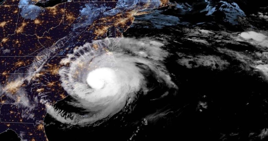
Landfall at 7.15am 9/14/18 near Wrightsville Beach, NC:
My two previous threads:
Landfall at 7.15am 9/14/18 near Wrightsville Beach, NC:
(2) I'm following updates on these Twitter lists:
16 key national info sources for hurricanes & other emergencies:
twitter.com/GodlessNZ/list…
EM agency accounts in 11 Atlantic states from GA to NY and inland:
twitter.com/GodlessNZ/list…
16 key national info sources for hurricanes & other emergencies:
twitter.com/GodlessNZ/list…
EM agency accounts in 11 Atlantic states from GA to NY and inland:
twitter.com/GodlessNZ/list…
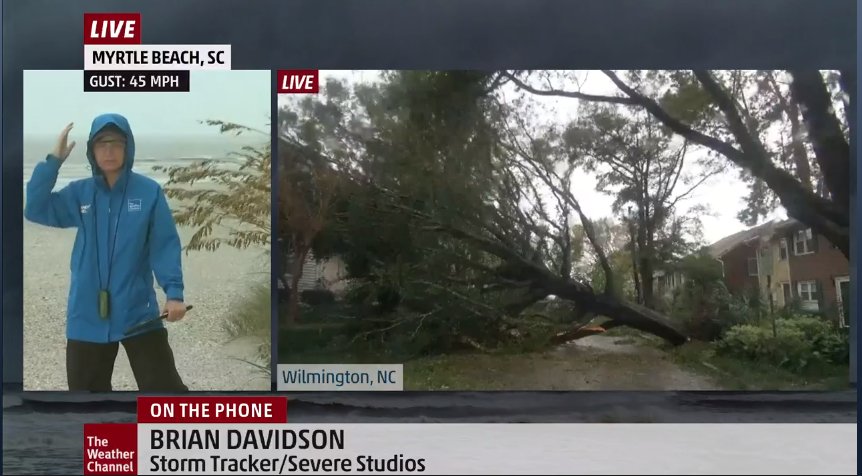
(3) Also finding the Weather Channel coverage valuable. Watching it here:
weather.com/tv/the-weather…
weather.com/tv/the-weather…
(4) Almost all of the impacts so far have been in NC. Here is the state government information page: ncdps.gov/florence
(5) The key msg about #Florence is ignore the Cat 1 (lowest wind speed range for a hurricane) because the deadly flooding is more important.
But even as a Cat 1 she had high wind *for NC*. A storm this bad is not rare for the USA, but she is rare for NC.
But even as a Cat 1 she had high wind *for NC*. A storm this bad is not rare for the USA, but she is rare for NC.
(6) Check out @FEMA's Rumor Control page for #Florence. There are already several incorrect claims that are debunked/corrected here:
fema.gov/florence-rumors
fema.gov/florence-rumors
(7) Update from the American Red Cross:
(8) I was not expecting to see trees of this size uprooted by Cat 1 #Florence. Winds of around 100 mph can do it. Lots of reports of letterboxes, signs, posts, doors etc ripped off and blown around.
Please take this storm seriously. The multi-day ordeal is just starting.
Please take this storm seriously. The multi-day ordeal is just starting.
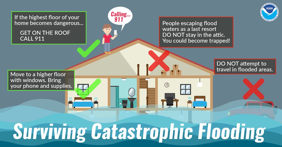
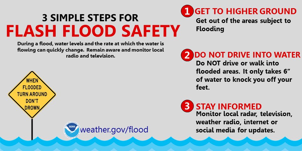
(9) Safety message for those affected by the historically high levels of flooding and flash flooding in the path of hurricane #Florence over the next >3 days.
Don't go into the attic, you could get trapped there.
Go onto the roof instead.
Use a bedsheet to be seen by rescuers
Don't go into the attic, you could get trapped there.
Go onto the roof instead.
Use a bedsheet to be seen by rescuers

(10) Awe-inspiring.
(11) The storm in the Gulf that was #95L and never became Tropical Storm Kirk, will still cause noticeably severe weather in Texas. For me it shows the advantage of naming storms - it raises greater awareness. But the line must be drawn somewhere.
(12) Police in Wilmington, NC have confirmed two deaths from a fallen tree, the first fatalities of Hurricane #Florence.
(13) Daily reminder: Sending cash is better than sending goods, especially second hand goods. Avoid the #SecondDisaster of diverting workers away from important tasks while they sort through donated goods (that may be unsafe, too.) #Florence
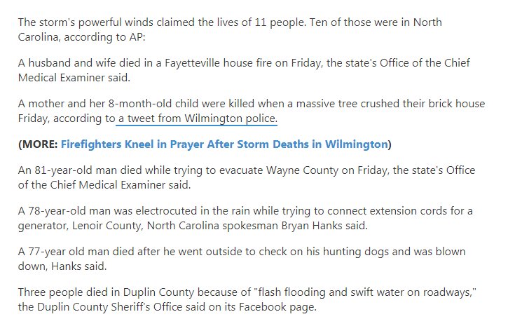
(14) #Florence death toll rises from 2 to 4:
>A woman in Pender Co. suffered a fatal heart attack, first responders couldn't reach her because of storm debris in the roadway.
>In Lenoir Co. a person was killed while plugging in a generator.
RIP😢
>A woman in Pender Co. suffered a fatal heart attack, first responders couldn't reach her because of storm debris in the roadway.
>In Lenoir Co. a person was killed while plugging in a generator.
RIP😢
(15) "FLASH FLOOD EMERGENCY 4 #Carteret #Jones #Craven #Pamlico counties. Unprecedented rainfall approaching 2 FEET in Carteret! Widespread flooding occurring. This is a particularly dangerous situation. Most roads across the area becoming impassable. AVOID AREA!" @JimCantore
(16) #Florence seems like the slowest storm imaginable. She has only now officially moved into South Carolina. The #FlashFlooding risk to life in certain parts of NC atm is extreme, and will stay that way for at least 36 more hours.
Just awful.
Just awful.
(18) This size and intensity of storm 12 hours after landfall is not something I'm used to seeing. #Florence has moved along the coast at 3-6 mph and appears to be turning inland at last. Each hurricane teaches me more about hurricanes.
(19) "Flash flooding is expected from #Florence throughout the Carolinas and southwest Virginia through early next week. Water levels and the rate at which the water is flowing can quickly change. Get to higher ground. Do not drive or walk into water." @NWS
#TurnAroundDontDrown
#TurnAroundDontDrown

(21) This is a must-watch 1:30 video clip on certain NC & SC rivers that are still to reach peak flood levels during the next 5-10 days. #Florence
In some areas, power is starting to be restored, but for other areas the worst flooding is yet to come.
In some areas, power is starting to be restored, but for other areas the worst flooding is yet to come.
(22) "Additional rainfall forecast between 8 a.m. today and Wednesday. Catastrophic flooding is still forecast for some communities. #TurnAroundDontDrown #Florence" @WeatherNation
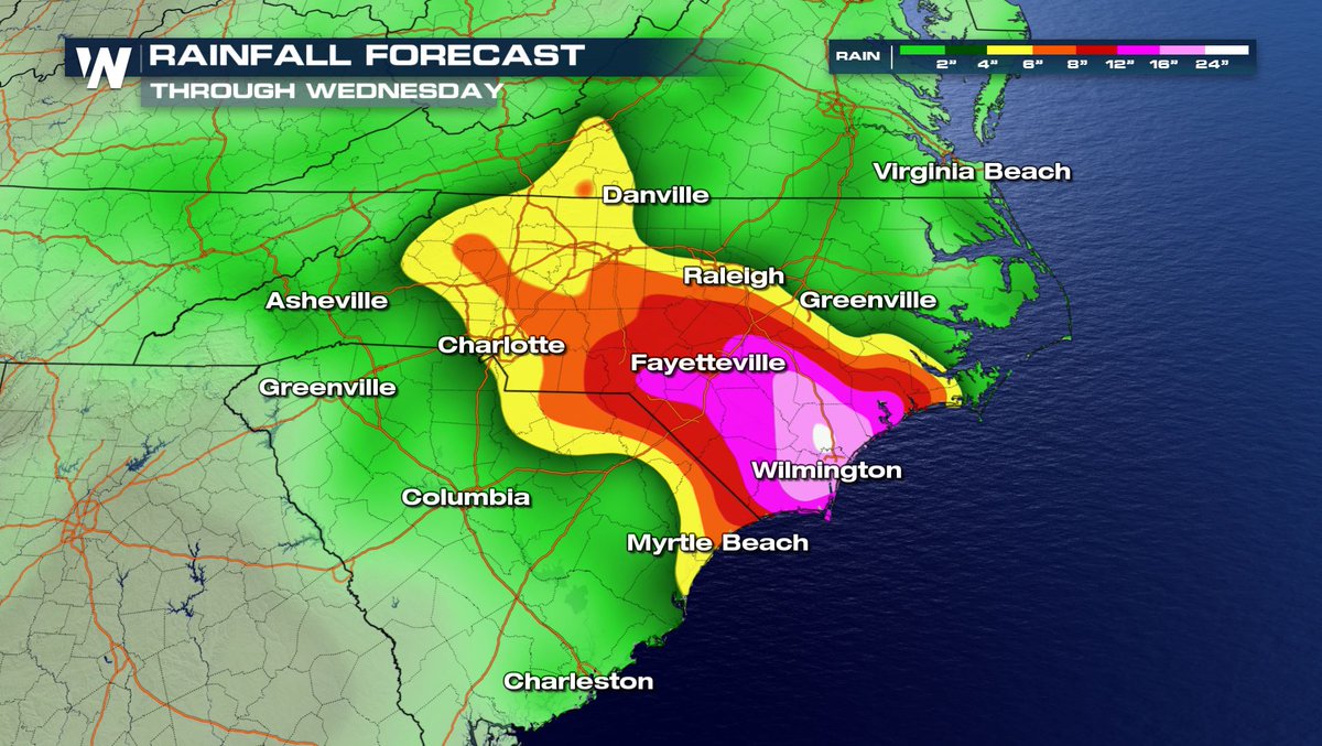
(23) #Fayetteville and nearby areas are now under a mandatory evacuation order. The chart below shows the extreme flooding that is predicted there. #Florence

(26) The death toll from #Florence now stands at 8.
A 61yo woman's vehicle collided with a fallen tree that was hanging a few feet above the roadway:
wyff4.com/article/pickup…
3 separate cases of driving through floodwaters:
witn.com/content/news/T…
🚨#TurnAroundDontDrown🚨
A 61yo woman's vehicle collided with a fallen tree that was hanging a few feet above the roadway:
wyff4.com/article/pickup…
3 separate cases of driving through floodwaters:
witn.com/content/news/T…
🚨#TurnAroundDontDrown🚨
(27) It's time for West Virginia, Kentucky, Ohio, and Virginia folk to pay closer attention to the hazards they now face from #Florence. Even when the storm becomes a low/depression, it will still be a significant danger. Glacial speed increases rainfall.
(28) "If ur trying to get in touch with loved ones affected by #Florence, keep in mind that comms may be spotty while the storm moves through.
📱Try texting or using social media to connect with them. Keep trying.
🖥Check safeandwell.org" @FEMA
📱Try texting or using social media to connect with them. Keep trying.
🖥Check safeandwell.org" @FEMA
(29) For all intents and purposes, #Florence is now stationary. Only moving at 2 mph.
Some NC locations have already had over 32 inches of rain, and they have at least 15 inches to come... I think they will probably end up over 50 inches in total.
Some NC locations have already had over 32 inches of rain, and they have at least 15 inches to come... I think they will probably end up over 50 inches in total.
(30) AP is collating reports of #Florence related deaths and it now says there are 11, 10 of them in NC.
Source of excerpt: weather.com/storms/hurrica…
Source of excerpt: weather.com/storms/hurrica…
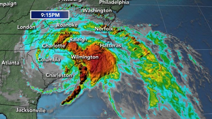
(31) This latest radar image shows the band of heavy rain that's about to curve around from Wilmington to Charlotte tonight (the darker colors out at sea). There will be continued tornado warnings in NC. I'll add a tornadoes tip sheet in the next tweet. #Florence
(32) Here's what to do when tornadoes threaten or occur: