
Two big announcements today from @GeospatialC:
● release of UPRNs/USRNs under OGL gov.uk/government/new…
● 10-year Public Sector Geospatial Agreement with OS gov.uk/government/new…
Good or bad news for #opendata and the UK's #geospatial strategy?
Let's have a look.
1/n
● release of UPRNs/USRNs under OGL gov.uk/government/new…
● 10-year Public Sector Geospatial Agreement with OS gov.uk/government/new…
Good or bad news for #opendata and the UK's #geospatial strategy?
Let's have a look.
1/n
See also:
● @GDSteam post on UPRNs/USRNs as #openstandards technology.blog.gov.uk/2020/04/02/ide…
● @GeoPlaceLLP press release geoplace.co.uk/news-events/ne…
● @OrdnanceSurvey press release on the PSGA ordnancesurvey.co.uk/business-gover…
● OS's updated "Open MasterMap" page ordnancesurvey.co.uk/business-gover…
2/n
The "Open MasterMap" products and APIs mentioned in today's announcement will go live in summer 2020, so there's no #opendata you can download right away.
We don't yet have full specs either. For example OS is still validating its proposal for the Open USRN dataset.
3/n
We don't yet have full specs either. For example OS is still validating its proposal for the Open USRN dataset.
3/n
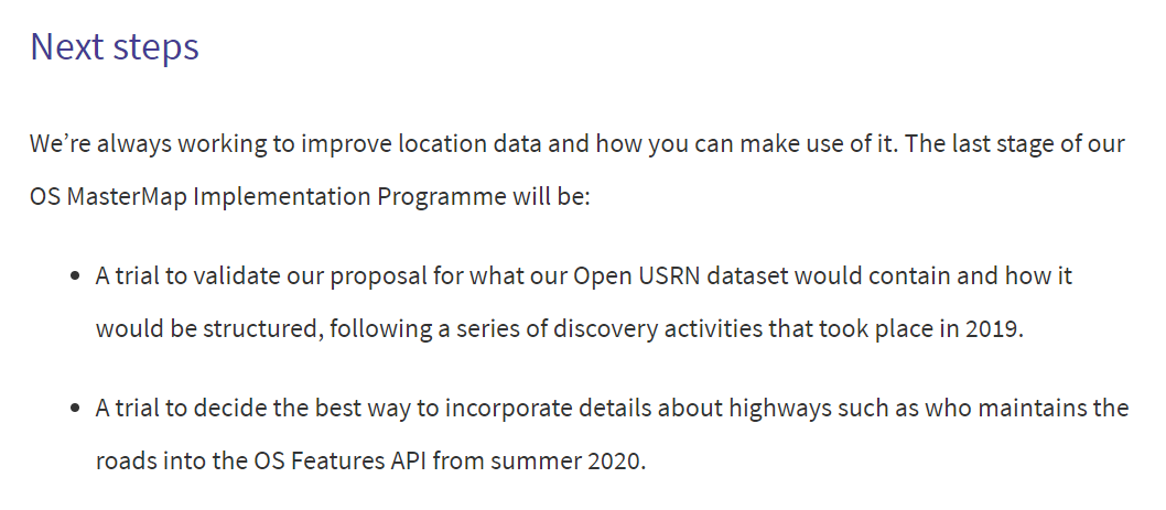
As background: the "Open MasterMap" initiative was first made public as part of the #GeospatialCommission announcement in the November 2017 Budget. We have been waiting more than two and half years for the outputs from OS. gov.uk/government/new… + gov.uk/government/pub…
4/n
4/n
The most significant development in today's announcements is that Government has reneged on its promise to release a property extents dataset, created from OS MasterMap Topography Layer, as #opendata.
Buried in the detail of the OS update: ordnancesurvey.co.uk/business-gover…
5/n
Buried in the detail of the OS update: ordnancesurvey.co.uk/business-gover…
5/n
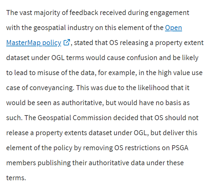
These excuses will be wearily familiar to #opendata campaigners. The property extents proposal was never more than a cheap substitute for open release of HMLR title polygons. The GC is now convinced that even that would be too much of a threat to OS's commercial monopoly.
6/n
6/n
(Basically this is an extension of OS's "presumption to publish" scheme, which is supposed to permit use of derived data in #opendata products but is inherently non-strategic in its results. See for example the piecemeal progress on unlocking Public Rights of Way data.)
8/n
8/n
There is better news on #identifiers, where OS has confirmed plans to publish key location identifiers – UPRN, USRN and TOID – as new #opendata products. ordnancesurvey.co.uk/business-gover…
GDS will "mandate" use of UPRNs and USRNs as government #openstandards. technology.blog.gov.uk/2020/04/02/ide…
9/n
GDS will "mandate" use of UPRNs and USRNs as government #openstandards. technology.blog.gov.uk/2020/04/02/ide…
9/n
Crucially these releases of core location identifiers as #opendata will include associated geometry. However as always with OS the devil is in the detail: line geometry for USRNs will be "simplified" and the TOID coordinates will be "generalised". ordnancesurvey.co.uk/business-gover…
10/n
10/n

Identifiers as #opendata is progress, but not without risks. Much of the information the identifiers represent (addresses, detailed polygons) remains non-open. Publishers who use the identifiers in place of that missing information may be upselling OS's commercial products.
11/n
11/n
Today's announcements also include some further information on the APIs for free (but not open) data from MasterMap and other OS products. These measures are aimed at small businesses and the free threshold has been set at £1,000 per calendar month. ordnancesurvey.co.uk/business-gover…
12/n
12/n
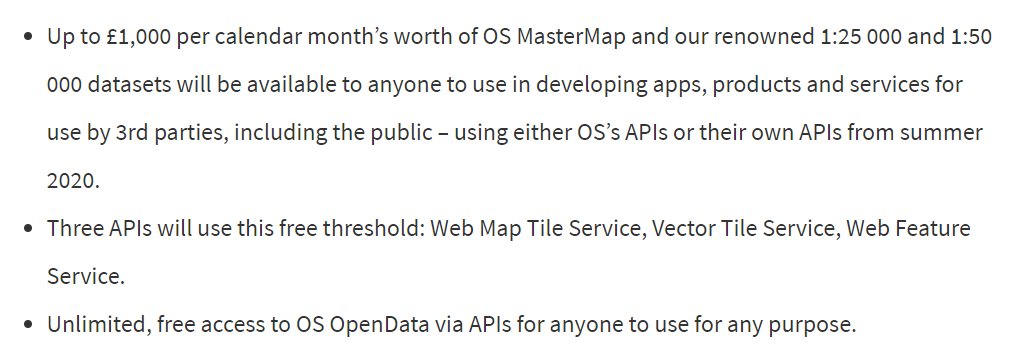
For those of us who aren't OS partners it's difficult to judge how much free data that is. OS seems to have stopped publishing its price list. webarchive.nationalarchives.gov.uk/20190701153755…
However the threshold may not be as generous as some were hoping, and the terms of re-use remain unclear.
13/n
However the threshold may not be as generous as some were hoping, and the terms of re-use remain unclear.
13/n
Also announced today: a 10 year Public Sector Geospatial Agreement for public sector use of OS data. gov.uk/government/new… + ordnancesurvey.co.uk/business-gover…
Seems to be a rebadging of the PSMA and (soon) OSMA. Basically the same terms, but new products and tools in the pipeline.
14/n
Seems to be a rebadging of the PSMA and (soon) OSMA. Basically the same terms, but new products and tools in the pipeline.
14/n
The PSGA will be welcomed by peeps who work mainly in public sector geospatial and want assurance their OS data will remain free at the point of use.
But disappointing to those of us who hoped to see OS's best data re-used more flexibly, across sectors and on the open web.
15/n
But disappointing to those of us who hoped to see OS's best data re-used more flexibly, across sectors and on the open web.
15/n
From a licensing perspective the PSGA is only necessary because most of the data infrastructure maintained by OS is not open.
Like PSMA, the PSGA represents a strategic alternative to the open agenda and operates to reduce calls for #opendata from within the public sector.
16/n
Like PSMA, the PSGA represents a strategic alternative to the open agenda and operates to reduce calls for #opendata from within the public sector.
16/n
The ten year PSGA also suggests we should not expect anything transformative in the national geospatial strategy expected later this year. The Geospatial Commission has sent a strong signal that this Government is content with the status quo on public data infrastructure.
17/n
17/n


