
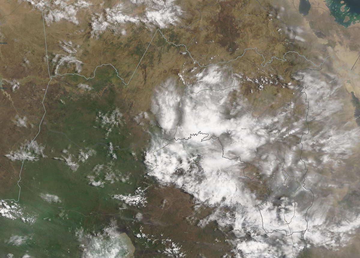
2 recent #pictures on day 5 of the 2021 Grand Ethiopian Renaissance Dam #GERD filling.
1. Satellite image this morning.
2 Date unknown, posted on Twitter today.
Meanwhile it looks as if the #HOA rain is about to get heavier. Today's forecasts follow.
1. Satellite image this morning.
2 Date unknown, posted on Twitter today.
Meanwhile it looks as if the #HOA rain is about to get heavier. Today's forecasts follow.


Today's big picture hasn't changed much.
TS #Elsa can still be seen bottom left, she will be crossing Cuba later today.
Bottom right we see storms over #Ethiopia and #Yemen.
In Europe the #EuropeBigWet continues with North Atlantic weather moving in from West.
TS #Elsa can still be seen bottom left, she will be crossing Cuba later today.
Bottom right we see storms over #Ethiopia and #Yemen.
In Europe the #EuropeBigWet continues with North Atlantic weather moving in from West.

This @NASA Modis satellite image series zooms in from...
1. The entire Nile
2. Ethiopia
3. #Abbay basin. Can you spot the #GERD?
4. Tigray.
1. The entire Nile
2. Ethiopia
3. #Abbay basin. Can you spot the #GERD?
4. Tigray.


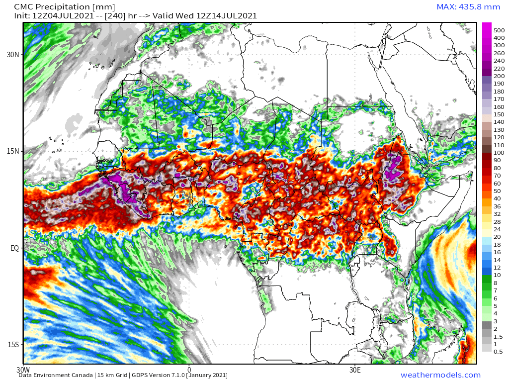
@NASA Today's 10-Day Rainfall forecasts for North Africa from July 4th through July 15th.
[NOTE: The KMA model data feed to @weathermodels_
seems to be down today.]
[NOTE: The KMA model data feed to @weathermodels_
seems to be down today.]


48-hour rainfall forecasts (today and tomorrow from the same four models: the Euro @ECMWF, U.S. @NOAA's GFS, Canada's CMC and models.
In all forecasts short and long range we now see rainfall pushing deep into northern areas in the Sahel.
In all forecasts short and long range we now see rainfall pushing deep into northern areas in the Sahel.


Here we see a six hour animation of a satellite view of today's cloud activity over Ethiopia. [Src. @zoom_earth]
@zoom_earth Zooming out we can see the Arabian Sea and the source of the Monsoon winds as well as storm activity building up in Yemen.
@zoom_earth Today's July 4th 10-day rainfall forecasts for #Ethiopia and the #HornOfAfrica including #Somalia, #Somaliland, eastern parts of #SouthSudan, south eastern parts of Sudan, #Djbouti and #Eritrea. All model forecasts are now both strong and stable. [KMA not included.]


48 Hour forecasts (today and tomorrow) from the same two models. The big rainy season is now underway.
The final image shows rainfall today up to 9pm local time as estimated from satellite imagery [Src. @Meteoblue]
The final image shows rainfall today up to 9pm local time as estimated from satellite imagery [Src. @Meteoblue]


This animation show's today's #ArabianStorms and today we also have some eyewitness videos courtesy of @Arab_Storms.
A Jazan lightning strike #SaudiArabia
https://twitter.com/Arab_Storms/status/1411752877505273857?s=20
Water flowing off the mountains in #Oman
https://twitter.com/Arab_Storms/status/1411695989111414784?s=20
And an enthusiastic fellow celebrating the rain with his head in #SaudiArabia.
https://twitter.com/Arab_Storms/status/1411694766652203010?s=20
10-Day July 3rd, accumulated rain forecasts for the #MiddleEast from the GFS, CMC & ACG weather models.
#ArabianStorms
#KSA #Yemen #Oman #Jordan #Sudan #Iran #Syria #GERD #Sudan #DesertRain
الله أعلم
#ArabianStorms
#KSA #Yemen #Oman #Jordan #Sudan #Iran #Syria #GERD #Sudan #DesertRain
الله أعلم


48 Hour July 4th (today and tomorrow), accumulated rain forecasts for the #MiddleEast from the GFS, CMC, UK Met and ACG weather models.
#ArabianStorms
#KSA #Yemen #Oman #Jordan #Sudan #Iran #Syria #GERD #Sudan #DesertRain
الله أعلم
#ArabianStorms
#KSA #Yemen #Oman #Jordan #Sudan #Iran #Syria #GERD #Sudan #DesertRain
الله أعلم


As always the final rainfall forecasts are long range July 4th forecasts. Today we have 16-day (GFS) and 360hour (EPS ensemble model) and 16-day (GEFS ensemble model) accumulated rainfall forecasts for the Middle East..
الله أعلم
الله أعلم


...Threadfix...
https://twitter.com/althecat/status/1411770252615208965?s=20
& a rounded picture of the hemisphere. Zero hour simulation data from the GFS.
1. Precipitable water PWAT anomaly
2. PWAT (potential rain + energy)
3. MLSP (Mean Sea Level Pressure)
4. 250Hpa (jet stream winds approx 11kms high)
1. Precipitable water PWAT anomaly
2. PWAT (potential rain + energy)
3. MLSP (Mean Sea Level Pressure)
4. 250Hpa (jet stream winds approx 11kms high)


Finally in today's thread I will return to a matter raised yesterday. I.E. that a significant increase in monsoon activity over the Indian Ocean next week may lead to significant step up in rainfall over the #HOA this time next week.
https://twitter.com/althecat/status/1411414277257318405?s=20
In yesterday's thread I looked only at the GFS model looking forward at the Indian monsoon. The three images here are from the ECMWF model and they confirm the sequence. By July 14th the area of monsoon level atmosphere will have reached Ethiopia.
https://twitter.com/althecat/status/1411415781771026438?s=20


These animations which show July 11th to 14th show the arrival of the tropical level moisture in Ethiopia
Above we have the European @ECMWF model forecast. And here the CMC (Canadian) model.
And this model, the Australian ACG model also shows the same thing, which makes four major weather models all in agreement that a significant change will take place next weekend which could lead to a step-up in the intensity of rainfall.
https://twitter.com/althecat/status/1411790288868282371?s=20
We shall see what that impact looks like next week. But it stands to reason that in order for this flow profile for the Nile to be met, significantly more rain will need to fall.

• • •
Missing some Tweet in this thread? You can try to
force a refresh


