
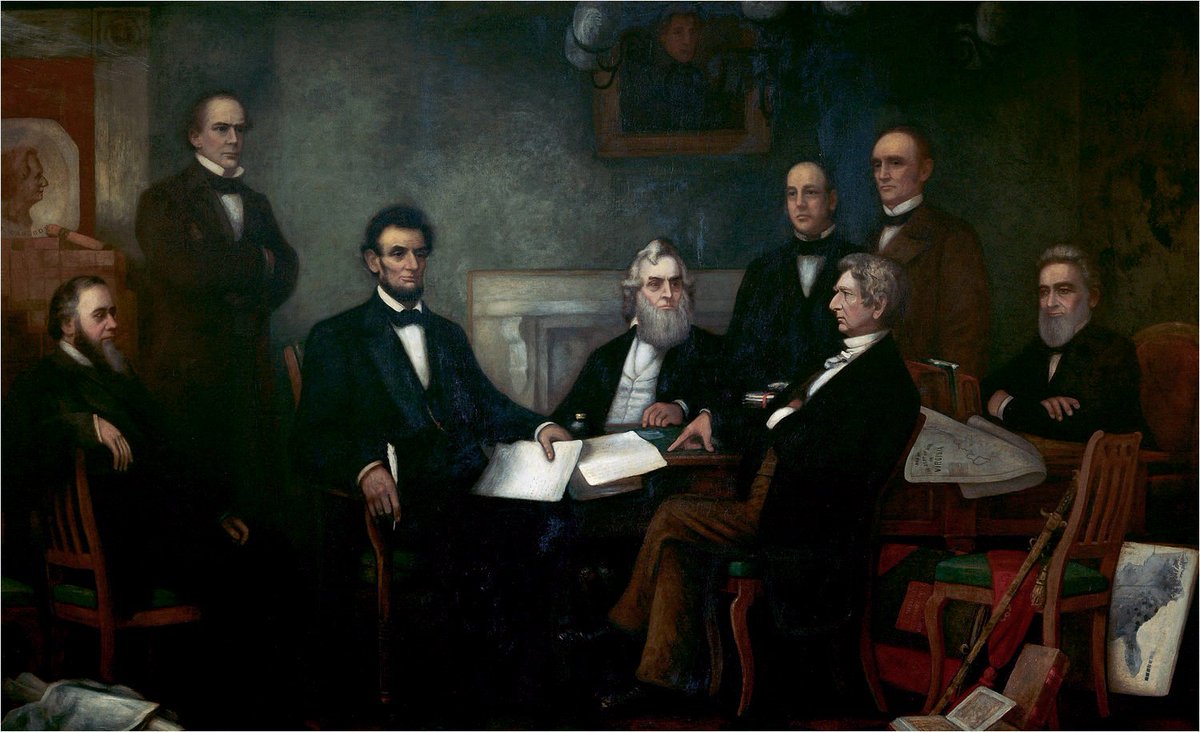
1/ This is a famous painting, "First Reading of the Emancipation Proclamation by President Lincoln”, by Francis Bicknell Carpenter: 

2/ You can see Lincoln holding the Emancipation Proclamation while cabinet members such as Salmon P. Chase (standing at left) and William Seward (seated at right, facing Lincoln) listen.
3/ But this painting has almost as many documents and books as it has people. There’s the Proclamation itself, in Lincoln’s hand and (in a second page, I believe) on the table in front of him.
4/ But focus for a moment on the lower right hand corner of the painting. There’s a map, half-seen, leaning up against a table leg, showing the southern United States (then currently in rebellion).
5/ That’s not just an artist’s embellishment. It’s a rendition of a real, and very important, map: “Map Showing the Distribution of the Slave Population of the Southern States of the United States,” from the 1860 Census, by Edwin Hergesheimer:
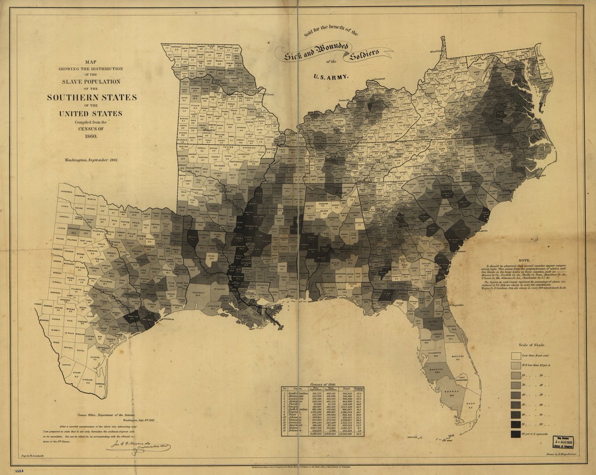
6/ We’re used to maps like that today, that show data on the map by use of shading or coloring. But in 1861, that was still relatively new. That type of map, now called a “choropleth map”, was invented in 1826 and only became popular in the years leading up to the Civil War.
7/ This map simply reproduced the results of the 1860 U.S. Census, which calculated for each county the total number of free individuals and the total number of enslaved individuals.
8/ What made this such a brilliant map and data visualization was that it didn’t just represent data geographically, but it represented important geographic trends.
9/ Looking at this map, you can see the highest concentration of slaves in South Carolina, Mississippi, Louisiana, and Alabama. The order of secession from the US: South Carolina, Mississippi, Florida, Alabama, Georgia, Louisiana.
10/ So this map, intentionally or not, weighed in on a political debate at the time (that hasn’t entirely died down): was the Civil War primarily about slavery or state’s rights? This map suggested the former. (So do the states’ actual slavery-heavy stated reasons for secession.)
11/ You can also see some exceptions to the trends. Western Virginia —what would soon become the separate state of West Virginia — has very few slaves. So does Eastern Kentucky. Missouri and Maryland have slaveholding pockets but otherwise have few slaves.
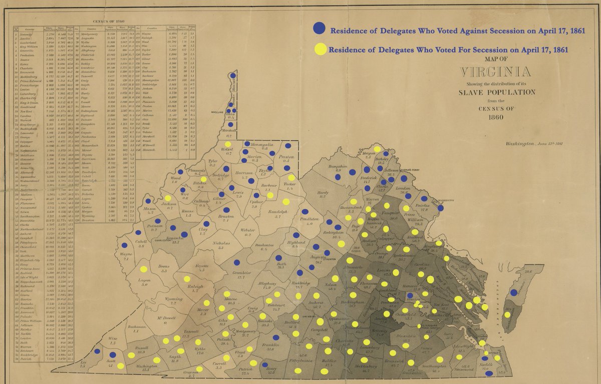
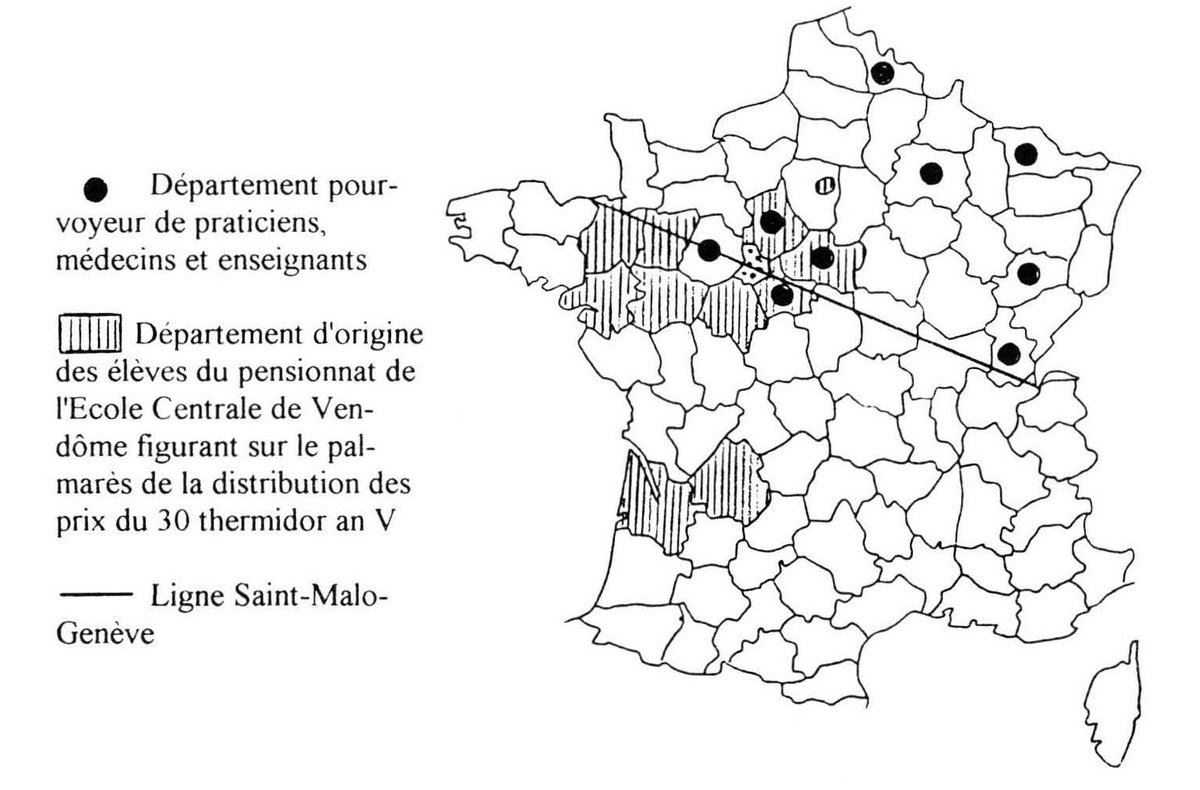
12/ The cartographer, Hergesheimer, did a similar map for just Virginia. Here someone has overlaid how delegates voted in Virginia’s 1861 secession convention (via edu.lva.virginia.gov/online_classro…)
13/ But the map just isn’t important TODAY as a historical tool to understand slavery and the Civil War. It was, at the time it was produced, important as a document.
14/ Francis Bicknell Carpenter, who painted "First Reading of the Emancipation Proclamation by President Lincoln,” lived at the White House for six months while working on his painting.
15/ During that time, Carptner repeatedly saw the president studying the map. He put it in the painting because it was important to LINCOLN, as well as being important generally.
16/ Carpenter actually took the map to try to capture it for his painting. A few days later, Lincoln walked into his studio and said, “You have appropriated my map, have you? I have been looking all around for it.” Then he put on his glasses and began looking at it again.
17/ (Abraham Lincoln was delightful.)
18/ Lincoln called it his “slave map.” He liked it because it showed the South wasn’t monolithic. And he used it to track the progression of Union military incursions into the South.
19/ After Lincoln began looking at his map again in Carpenter’s studio, in early 1864, he immediately pointed out the location of a recent cavalry raid into Virginia by Judson Kilpatrick, a Union General.
20/ “It is just as I though it was,” Lincoln said, pointing to Kilpatrick’s position. “He is close upon — County, where slaves are thickest. Now we ought to get a ‘heap’ of them, when he returns.” books.google.com/books?id=YSEwY…
21/ Lincoln had also used the raw data on slave population from the 1860 Census to calculate the feasibility of “compensated emancipation” — paying slaveowners for the loss of their slaves. He may have used this map for that, too.
22/ But by 1863 Lincoln had abandoned the idea of compensated emancipation — as the fact that this map features in a painting about the Emancipation Proclamation shows.
23/ Instead, the map was now being used to follow — and possibly to direct — military incursions to liberate slaves by force.
24/ In conclusion, maps are great, and have been important for a really long time.
25/ Some sources: “Mapping Slavery in America” by UChicago Press: press.uchicago.edu/books/akerman/…
"Mapping the Nation: History and Cartography in Nineteenth-Century America” by Susan Schulten: books.google.com/books?id=YSEwY…
"Mapping the Nation: History and Cartography in Nineteenth-Century America” by Susan Schulten: books.google.com/books?id=YSEwY…
26/ "Map of April 17, 1861, Vote on Secession” from the @LibraryofVA: edu.lva.virginia.gov/online_classro…
"The Map That Lincoln Used to See the Reach of Slavery” by @rebeccaonion: slate.com/blogs/the_vaul…
"The Map That Lincoln Used to See the Reach of Slavery” by @rebeccaonion: slate.com/blogs/the_vaul…
27/ Information about "First Reading of the Emancipation Proclamation by President Lincoln” on Wikipedia: en.wikipedia.org/wiki/File:Eman…
“Mapping Slavery” from the Library of Congress: blogs.loc.gov/loc/2012/10/ma…
“Mapping Slavery” from the Library of Congress: blogs.loc.gov/loc/2012/10/ma…
28/28: Thanks for reading. This tweetstorm was spurred by Hergesheimer map being shared on @reddit’s @MapPornTweet forum: reddit.com/r/MapPorn/comm…
29/28 (This tweetstorm also probably spurred by the fact that I had other things I was *supposed* to do tonight.)
Some more information on historical tangents from this thread: That raid by Kilpatrick that Lincoln was following on his “slave map”? It caused a scandal when one of Kilpatrick’s subordinates was killed with a copy of his orders: en.wikipedia.org/wiki/Hugh_Juds…
Kilpatrick was nicknamed “Kill-Cavalry” because of the high casualty rates his men suffered. Sherman nonetheless picked him for his Atlanta Campaign: "I know that Kilpatrick is a hell of a damned fool, but I want just that sort of man to command my cavalry on this expedition."
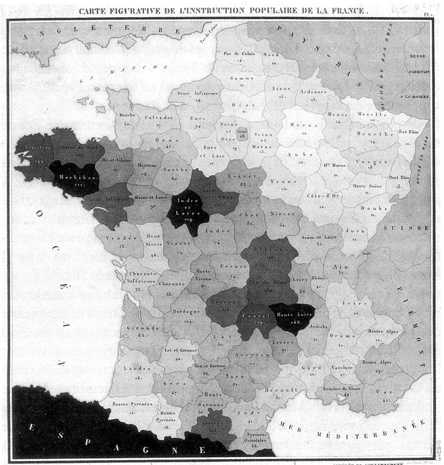
The choropleth map was relatively new when Hergesheimer made his in 1861. It was invented in 1826 by a French economist, Charles Dupin: en.wikipedia.org/wiki/Charles_D…
Dupin invented this art form to map illiteracy in Restoration France. Darker areas have higher rates of illiteracy:
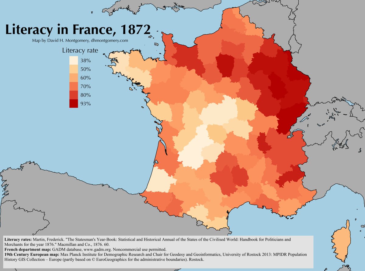
Coincidentally, a few years ago I made a similar map of French literacy in the 1870s, & wrote an essay about the spread education and literacy in the Third Republic: dhmontgomery.com/2015/07/alphab…
Carpenter’s studio in the White House? It was the White House’s State Dining Room: en.wikipedia.org/wiki/State_Din…
The composition in Carpenter’s painting is deliberate. Seated to Lincoln’s right (our left) are Secretary of War Edwin Stanton & Treasury Secretary Salmon P. Chase — the two cabinet members who enthusiastically supported the Emancipation Proclamation:

Though I must amend this. Carpenter asserted that Chase and Stanton were "actively supporting the new policy” of emancipation. Stanton indeed was. But opening up my Doris Kearns Goodwin I find a more nuanced picture: en.wikipedia.org/wiki/First_Rea…
Stanton backed emancipation, having “instantly grasped the military value.” Surprisingly, so too did Edward Bates, a conservative member of the cabinet — though Bates’ support was based on the idea that the freed slaves would be forcibly expelled back to Africa.
Bates “had long favored gradual emancipation,” Goodwin writes in “Team of Rivals,” but "if the president’s proclamation could bring the war to a speedier conclusion, he would give it his ‘very decided approval.’"
If Bates surprised the cabinet with his support of the proclamation, Chase surprised with his opposition to it. Chase had been a lifelong and vehement abolitionist, but now he argued Lincoln was moving too fast and backed a “quieter, more incremental approach.”
Goodwin argues that Chase, who harbored presidential ambitions, opposed the proclamation for selfish political reasons — it could undercut Chase’s strength vs. Lincoln among the radical faction of the Republican Party.
Seward, the secretary of state, argued against the proclamation, fearing it could “provoke a racial war in the South so disruptive to cotton that the ruling classes in England and France would intervene to protect their economic interests."
(In fact, Seward’s intuition was exactly backwards: the Emancipation Proclamation ultimately ended up bolstering support for the Union in Europe, where slavery was seen as “an evil demanding eradication.")
But once he saw Lincoln was committed, Seward “was steadfast in his loyalty.” His only objection was on timing: he urged Lincoln to wait until after a victory to issue the proclamation.
“The wisdom of the view of the Secretary of State struck me with very great Force,” Lincoln told Carpenter. “It was an aspect of the case that, in all my thought upon the subject, i had entirely overlooked.”
Lincoln, having presented the proclamation to his cabinet in July 1862, held onto it until after the technical victory in the bloody Battle of Antietam in September.
Carpenter’s painting actually reflects the moment when Seward made his concerns known. Notice how the cabinet is looking not at Lincoln or the document, but off-center at Seward.

"To the Secretary of State, as the great expounder of the principles of the Republican party... would the attention of all at such a time be given,” Carpenter wrote.
Though the people in the painting are looking at Seward, the light and color highlights the Emancipation Proclamation itself — a shining point of light in an otherwise dimly lit room.
The left side of the painting — where Carpenter positioned the cabinet members he saw as supporters of emancipation — is lighter than the right side, where the skeptics and opponents sit.
Off-center, but at the center, is Lincoln. "There were two elements in the Cabinet–-the radical and the conservative. Mr. Lincoln was placed at the head of the official table, between two groups, nearest that representing the radical; but the uniting point of both."
A few other grace notes in the painting: the painting on the wall at the center is Andrew Jackson, who was a slaveholder but also a fierce opponent of secession. At left is a painting of Simon Cameron, a former member of the cabinet, now resigned under a cloud of scandal.
Cameron had been secretary of war. Despite having resigned, Carpenter puts him at the scene indirectly, via a hung painting.
I can’t speak to its significance, but on examining that painting closely now I’m struck by the presence of a sheathed sword leaning against the chair between Seward, Bates and Hergesheimer’s map:
Alright, I think I’m really done now.
(I’m probably not.)
I should correct that Dupin’s map is not showing illiteracy, but rather the percentage of male children attending school.

Dupin made moral and economic arguments about this: "The Treasury Department collects 6,820,000 fr. in land taxes from enlightened France, and 3,599,700 from dark France,” he estimated.
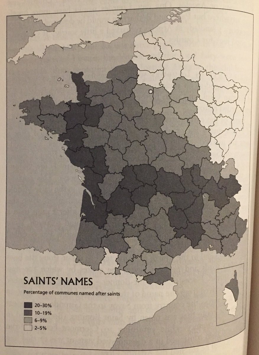
The division between light and dark on Dupin’s map sort of mirrors the famous “Saint-Malo-Genève Line”, a cultural and geographic divide between northern and souther France:
Author Graham Robb discusses this line in one of my favorite books, “The Discovery of France": "This imaginary line runs diagonally across the country from the Cotentin peninsula in the English Channel to the northern French Alps."
Robb: "At least until the late nineteenth century it appears with surprising regularity when various sets of data are plotted on a map…"
“…south and west of the line, people tended to be shorter and to have darker hair and eyes; they were less literate, lived in smaller places, had less taxable income and were more likely to be employed in agriculture."
The Saint-Malo-Genève Line even shows up when you map how often French places are named after saints! From Robb’s book:


