Cyclone #Yaas is just 2 days away from landfall on the North Eastern Indian Coast in the Odisha and once onshore is forecast pass over the ancient city of Jaipur.
Today's #MiddleEast #Sahara and #HornOfAfrica forecasts follow.
https://twitter.com/althecat/status/1396774140963692545?s=20
Today's #MiddleEast #Sahara and #HornOfAfrica forecasts follow.
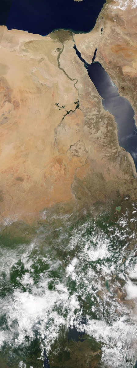
We have a stunningly clear image of the #NileBasin this morning from @NASA Modis from Cairo to Lake Victoria showing the impact of the April and May rains on the landscape. 
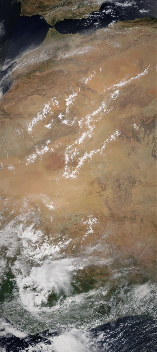
In today's 10-Day North Africa rain forecasts the European @ECMWF model remains unconvinced about the impact of #WestAfricaWaterPlumes on the Sahara, which as you will soon see are once again having a spectacular impact on European weather.


First we have an animation of today's cloud activity over the Western Sahara. The latest #WestAfricanMonsoon #WestAfricaWaterPlume is large but different than those before. Less like a river of water, slower and more dispersed, more like a migration.
This second animation shows the tip of the latest #WestAfricaWaterPlume plume entering Europe and heading like the last one over the alps bringing spectacular storms to Northern Italy.
[Thread on the last major plume event in early May >> threadreaderapp.com/thread/1389217…]
[Thread on the last major plume event in early May >> threadreaderapp.com/thread/1389217…]
Here are today's rainfall forecasts.
The 24th May 10-day rain forecasts for the #HornOfAfrica. It appears rain is spreading East and North once again.
#Sudan #SouthSudan #Ethiopia #HornOfAfrica #Somalia #Somaliland #GERD
The 24th May 10-day rain forecasts for the #HornOfAfrica. It appears rain is spreading East and North once again.
#Sudan #SouthSudan #Ethiopia #HornOfAfrica #Somalia #Somaliland #GERD
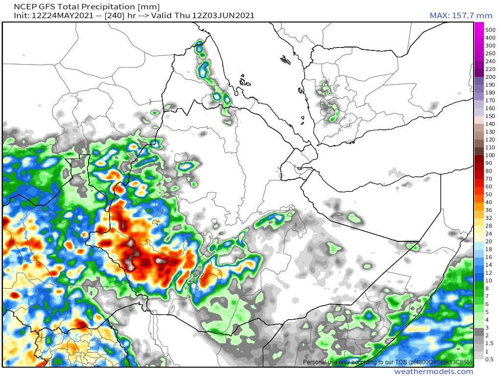

May 24th 3-day #HornOfAfrica rainfall forecasts till midnight Thursday.
#Sudan #SouthSudan #Ethiopia #HornOfAfrica #Somalia #Somaliland #GERD
#Sudan #SouthSudan #Ethiopia #HornOfAfrica #Somalia #Somaliland #GERD


Water vapour laden South Westerly winds continued over the Arabian Peninsula today bringing significant #ArabianStorm activity this afternoon and evening to the center of #SaudiArabia and also as the sun set to #Kuwait.
In this second animation, from earlier in the day there is another view of the scale of the South Westerly wind flow and its impact, over Iran.
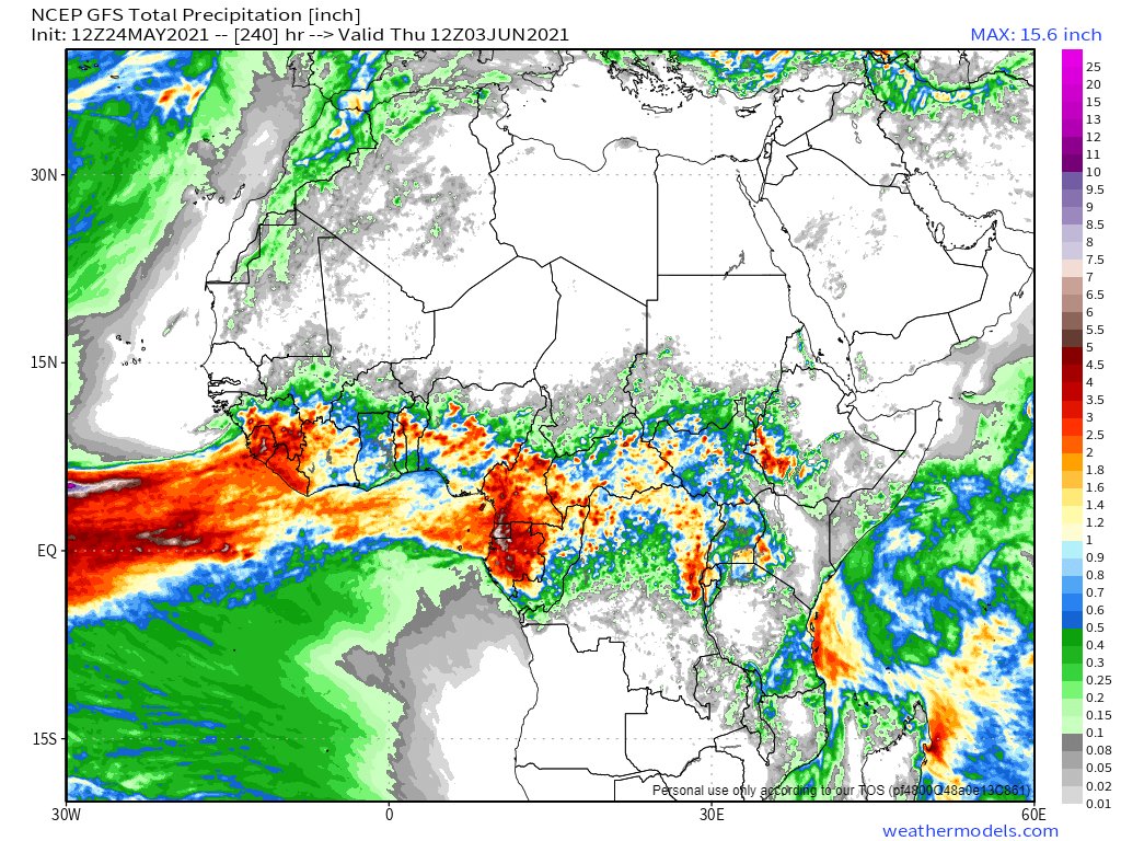
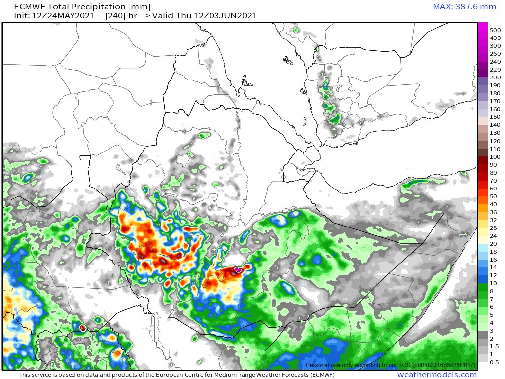
May 24th, 10 day accumulated rain forecasts for the #MiddleEast from the GFS, ECMWF, CMC & KMA weather models.
@Arab_Storms
#ArabianStorms
#KSA #Yemen #Oman #Jordan #Sudan #Iran #Syria #GERD #Sudan #DesertRain
الله أعلم
@Arab_Storms
#ArabianStorms
#KSA #Yemen #Oman #Jordan #Sudan #Iran #Syria #GERD #Sudan #DesertRain
الله أعلم


Today's 3-day accumulated rainfall forecasts for the #MiddleEast to midnight Thursday.
The third forecast below, Canada's CMC, caught today's Kuwait storm. The GFS and @ECMWF models do not appear to even be trying to seriously model what is happening here.
The third forecast below, Canada's CMC, caught today's Kuwait storm. The GFS and @ECMWF models do not appear to even be trying to seriously model what is happening here.


An amazing piece of video illustrating the impact of the winds in Kuwait from @Arab_Storms here.
https://twitter.com/Arab_Storms/status/1396897675946061826?s=20
Not sure exactly what we see here -also from #Kuwait but it looks to me like a heady mixture of of sand/dust storm & rain.
@Arab_Storms
https://twitter.com/Arab_Storms/status/1396896603168989184?s=20
@Arab_Storms
@Arab_Storms Today's #MiddleEast long-range 16 day and 12 day forecasts from the GFS and KMA models. We have the last two runs from each here.
The latest GFS is showing something that looks a bit like a tropical storm. While the KMA is showing significant rain over southern Sudan and Chad.
The latest GFS is showing something that looks a bit like a tropical storm. While the KMA is showing significant rain over southern Sudan and Chad.


Finally the trend shown in this animation which tracks #CycloneYaas making landfall at the beginning seems likely to have some significant impacts of Middle Eastern Weather as low pressure systems spread across a massive area.
This animation of water vapour/precipitable water is over a longer period and shows what looks like a spectacular Monsoon onset for the Indian subcontinent.
Compared to the last forecasts from Friday night (embedded thread) it seems that #ArabianSea storm activity is about to pick up a lot.
https://twitter.com/althecat/status/1396778429987622912?s=20)

#Threadfix.. .
@threadreaderapp unroll
https://twitter.com/althecat/status/1396950891362717696?s=20/Ends
@threadreaderapp unroll
• • •
Missing some Tweet in this thread? You can try to
force a refresh