
Seems like Edinburgh's East End was the temperance quarter a.k.a. the "dry triangle" back in 1893 (map from maps.nls.uk/geo/explore/#z…) 
I like the juxtaposition of the YMCA and the "Bodega" bar 
I can't remember how I came to look at this map this morning. Anyway there's a thread I've been meaning to do about the old way to name streets in Edinburgh, where the road gets one name and the buildings get another.
London Road is a case in point, hardly any buildings have address "London Road". Starting at the western end and heading out of town the buildings go Blenheim Place > Leopold Plc >Brunton Plc > Maryfield > E. Norton Plc > Cadzow Plc > Earlston Plc > Dalziel Plc > Meadowbank...
The "place" refers to a tenement development, these can be anything from single buildings to a row of 10 or 20 buildings. Back in the day they were named by either the party that fued the land or the builder. The principle roads were generally named where they were going from/to
Just to confuse matters, the "places" are normally named differently on different sides of the road London Road at Abbeyhill is East North Place and Cadzow Place on one side and Earlston Place and Maryhill on t'uther
The Edinburgh Co-operative Building Company, who built Edinburgh's "colony" housing kept up this trend, naming the rows of houses but not the actual streets. See here at Abbeyhill how the names are inside the building not on the road. 
This gives the confusing scenario where if you want the even numbers of, say, Alva Place you go to one street and if you want the odds you go to the next street. I've been totally caught out by this a number of times when going to view flats.
The east end of the Abbeyhill Colonies takes this to extremes, with a short street having different names on both sides and also different names on the same sides! That's before you take into account the corner buildings on London Road being "Earlston Place" addresses 
So that's one little 125m-long residential street having 4 different street addresses and requiring 6 different street signs. 
Needless to say, this details is entirely beyond Google's ken, who have named the streets and therefore gotten it totally wrong 
OSM gets it right (almost), naming the individual rows of buildings but also can't quite resist naming the end street 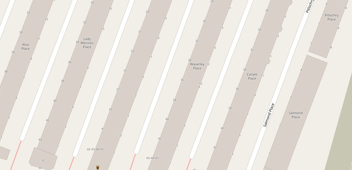
Come a mass public postal system things began to get out of hand as there were a number of different ways that you could style an address. This called for some rationalisation. Perhaps the most wholesale example was Leith Walk, which was built as a string of individual "places"
From the very "top" at Picardy Place, the facing "pairs" of places went Union Pl/ Greenside Pl> Antigua St/ Baxters Pl> Gayfield Pl> Haddington Pl/ Elm Row> Croall Pl/Brunswick Pl> Albert Pl/ Shrub Pl> George Pl/ Crichton Pl. We have now hit the Leith: Edinburgh boundary
On the Leith side, the development of the Victorian tenements we see today was later and they generally took Leith Walk addresses, although many older tenements and individual houses persisting for longer.
The older "place" names went Fyfe Pl > Kings Pl > Orchardfield/ Heriot's Buildings > Springfield > Ronaldson's Bldgs > Stead's Pl/ Anderson Pl> Allison's Pl> Whitfield's Pl/ Macneill's Pl> Cassell's Pl/ Queen's Pl. We are now at the foot of the Walk.
Confused? I am!
Here's an interesting thing. The names of most of the streets of "Marchmont" as we know it today are mainly after the country estatesonce owned by the Warrender family, who owned and fued the land for tenement development
The parcel of land that was fued to build "Marchmont" was the Warrender Park. It was apparently the intention that the suburb would also be called "Warrender Park", Marchmont was just to be the name of a few of the roads.
So how did Warrender Park come to be known as Marchmont? Well the story goes that it comes from the early days of trams reaching the suburb; it was simpler and easier for the signwriters to paint "Marchmont" on the destination boards.
Anyway, there are lots more examples of this - on late Georgian buildings you can often see an elegantly carved building name next to the modern street sign and sometimes the 2 don't match, in that difference there's a wee story.
In case you can't be bothered reading the whole thread, you can do so here as a quick webpage; threadreaderapp.com/thread/9608220…


