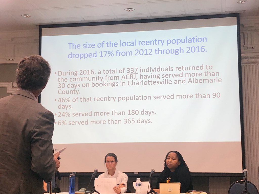
@elium2 You can always make a map from a public map, like the Paulding County map. Unfortunately, a pdf from their website doesn't save as a georeferenced pdf, but it's still doable with a few tricks that I never got around to fully explaining.
@elium2 If you're using QGIS, to do that, you need the GEOREFERENCER GDAL QGIS plugin. It's a core QGIS plugin which may or may not be enabled. To check, Select Plugins--> Manage and Install plugins & search for it.
@elium2 To open up the GEOREFERENCER, Select Raster --> Georeferencer --> Georeferencer, as seen below. The georeferencer should pop up. 
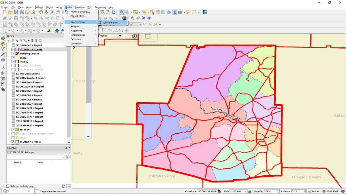
@elium2 First, you need to load your map or screenshot of your map as a raster file into the georferencer by 1) clicking on the blue and black checkerboard icon. Next, we need to georeference the map to a real-world shapefile before drawing a new Paulding County map.
@elium2 So, minimize the georefencer or Alt-Tab over to the main QGIS window and load Census' 2009 GA County shapefile. Then, reopen the georeferencer by clicking on the full screen square icon (the Georeferencer usually sits at the bottom left hand corner of QGIS once opened).
@elium2 You should probably find and zoom to Paulding County before moving back to the georeferencer because you're going to have to do that anyway to properly georeference the photo map. You should also make sure your map projection is census default, NAD 83, 4269.
@elium2 To properly georeference a photo map, you should take 3 or more points from a map and find them on the map in QGIS. This is done by hitting the (2) bird looking icon with a star, zooming in with the magnifying glass, and the clicking on an obvious point, like a corner or jut-in.
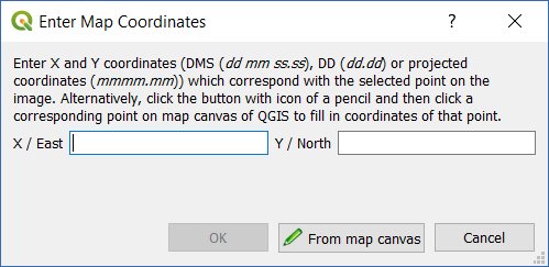
@elium2 A popup should appear. It looks like this:
Click on From map canvas. This will bring you back to main QGIS. Click on the same point in QGIS. That will bring you back to the Georeferencer window. Hit OK to save your point. Repeat at least 2 more times with different points.
Click on From map canvas. This will bring you back to main QGIS. Click on the same point in QGIS. That will bring you back to the Georeferencer window. Hit OK to save your point. Repeat at least 2 more times with different points.
@elium2 If you make a mistake, hit the bird icon with the red X underneath to delete that point.
@elium2 Here's the what the Georeferencer looks like with the marked buttons. I should have put this up earlier.
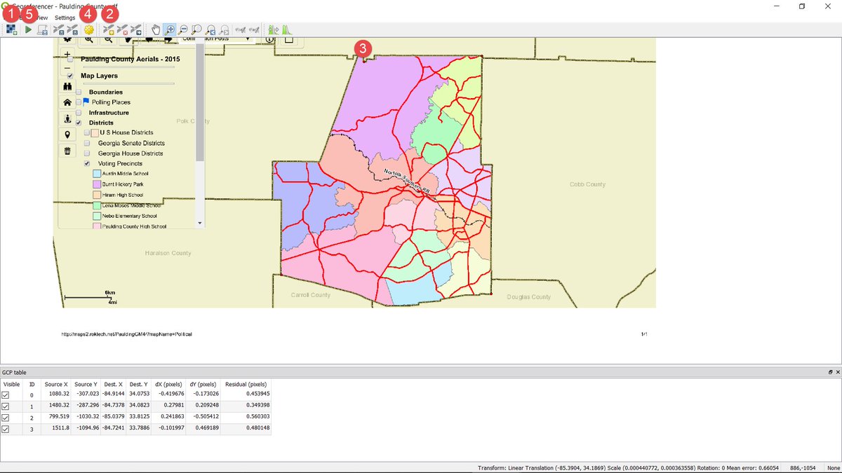
@elium2 Once you've made your points, to save your georeferenced map as a GEOTIFF file, first click on the 4) widget looking icon. Here, you can change the name if you wish - but the most important things are to make sure that the projection is 4269 - NAD 83 & check the Show in QGIS box.
@elium2 Finally, hit the 5) Green Arrow icon. This will actually georeference your map. Minimize the Georeferencer and make sure the map fits inside of Paulding County. To do this, it's best to change the style of the county layer to something that's transparent, like red outline.
@elium2 Now comes the not so easy part. I don't know how to directly transform a raster map into a vector shapefile. Perhaps someone else does & I'd welcome their input. But here's how I made my ID and SD maps from scratch:
@elium2 First, you'll need to download the Census Tiger/Line Edge file for Paulding County and a QGIS plugin called Join Multiple Lines. Census' files are here: census.gov/cgi-bin/geo/sh…
Select 2017/All Lines hit Submit, then Select Georgia/Paulding County. Unzip the file & open in QGIS.
Select 2017/All Lines hit Submit, then Select Georgia/Paulding County. Unzip the file & open in QGIS.
@elium2 The downloaded file, tl_2017_13223_edges.zip, contains all Census' lines for Paulding County - roads, rivers, railroads, etc., sometimes including older precinct boundaries, sometimes not. Fortunately, most precinct boundaries follow these edges.
@elium2 What I usually do to make these maps is cut the geometries in Census' 2012 VTD shapefile where necessary. Here' where Paulding County seems to have changed all boundaries, it might just make sense to cut up Paulding County.
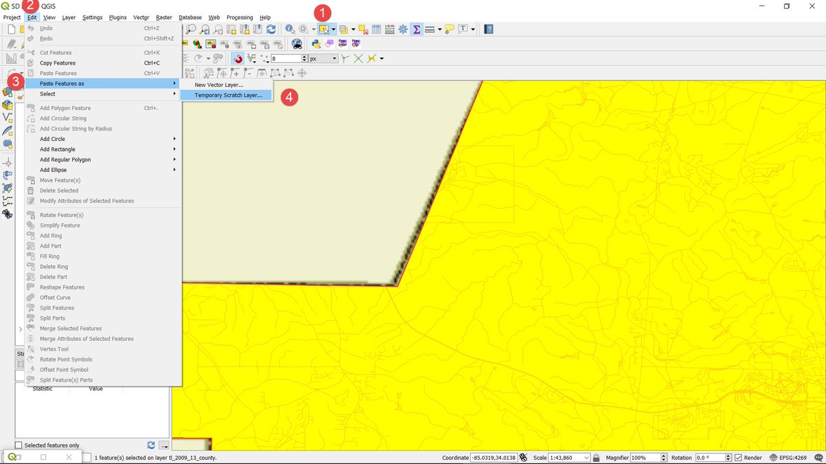
@elium2 To do that, Select Paulding County on the map by hitting the 1) Select Icon & copy it to the clipboard by hitting CTRL-C. Then, hit 2) Edit from the top menu 3) Paste Features as 4) Temporary scratch layer. A dialog will pop up. Name it whatever you want & hit OK.
@elium2 Next, we'll cut the county shapefile by the closest Census edge to the precinct lines on the georeferenced map. This is a little complicated and time consuming, but once you get the hang of it, it gets easier.
@elium2 Basically, if you don't know the name of the line at the precinct border, you need to manually select every segment of that line using the 1) select tool. To select multiple segments, hold the SHIFT key while selecting the second and subsequent lines. If you make a mistake...
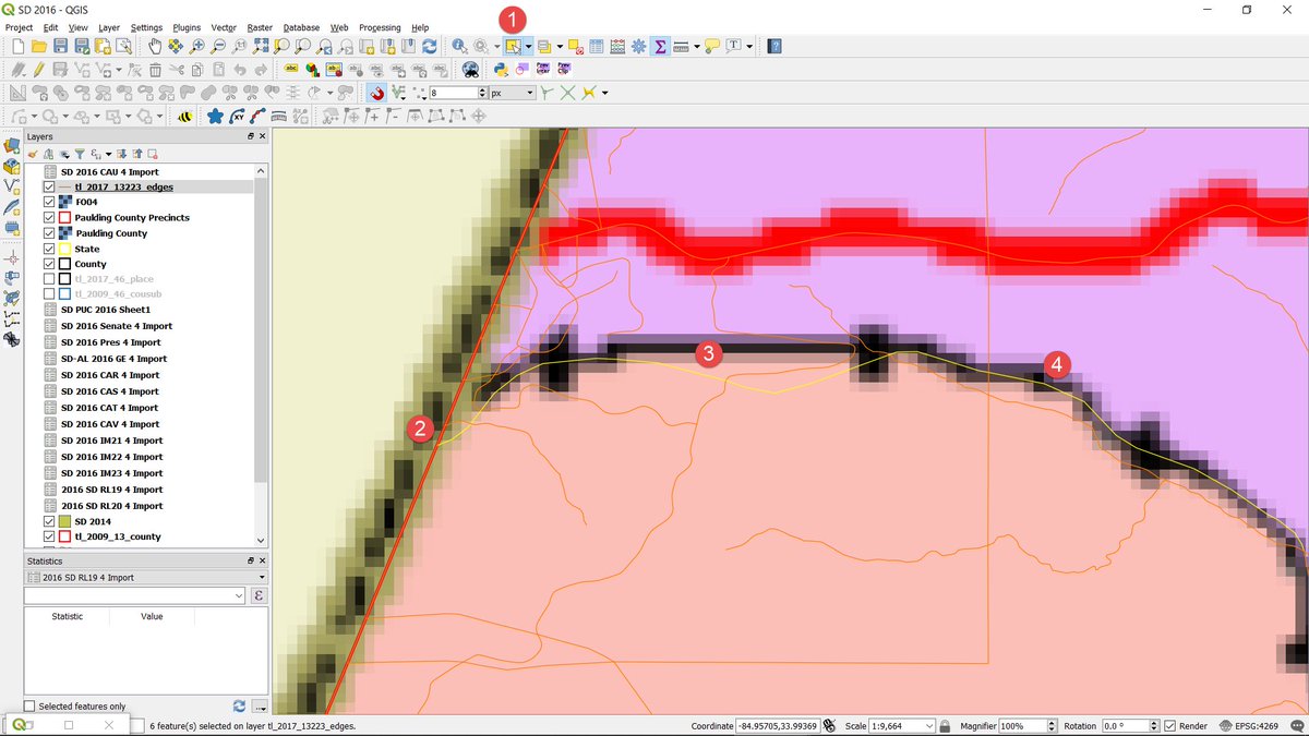
@elium2 hit the CTRL key and click on the segment that you didn't want to select. That will remove the line from your selection while keeping the others.
SHIFT-Select every segment along the precinct border until you reach another border.
SHIFT-Select every segment along the precinct border until you reach another border.
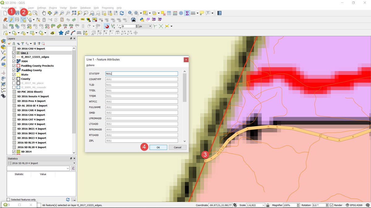
@elium2 When you're done selecting the full line, Copy and Paste it to a new temporary layer. I usually name these Line 1, Line 2, etc. To copy, you can hit CTRL-C or Edit-->Copy Features. To paste, do the same thing you did with the county layer - Edit-->Paste as --> Temp Scratch Layer.
@elium2 Next, I usually make Line 1 thicker by double clicking on the Line 1 Layer, selecting Symbology and then Primary Road. This allows us see any small gaps when we eventually merge the lines. But before we merge lines, we need to add two segments at each end.
@elium2 These segments must cross the Paulding county border before splitting it by line. To do this: hit the 1) pencil icon to make the layer editable, 2) hit the V* icon to add a line segment, 3) left click on the vertex at the border to draw a line, drag your mouse to draw a line...
@elium2 over the border, then 4) right click. A dialog will pop up. Hit OK, and a new line should be drawn. Go to the other border & repeat with another line segment at the end. If you make a mistake, you can hit the back arrow icon to delete the mistake.
@elium2 Or you can select the line segment and hit delete. Next, we'll merge the lines. To do this: 1) Deselect all lines from all layers by hitting the icon at 1. Then, after making sure you've selected the Line 1 layer in the layer panel, select all segments by hitting CTRL-A or...
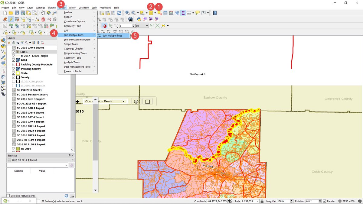
@elium2 hitting the down arrow on the icon at 2 until the select all icon appears and hitting that icon. Then, hit 3) Vector--->4) Join Multiple Lines--> 5) Join Multiple lines. If you've done this correctly, there will now be 1 line with no breaks.
@elium2 If you've done this incorrectly, there will be gaps in the line or you'll see multiple segments, looking like a triangle.
Next, we'll split the Paulding County layer by Line 1. To do this, open up the toolbox by hitting CTRL-Alt-T or 1) Processing-->2) Toolbox. 3) Search for...
Next, we'll split the Paulding County layer by Line 1. To do this, open up the toolbox by hitting CTRL-Alt-T or 1) Processing-->2) Toolbox. 3) Search for...
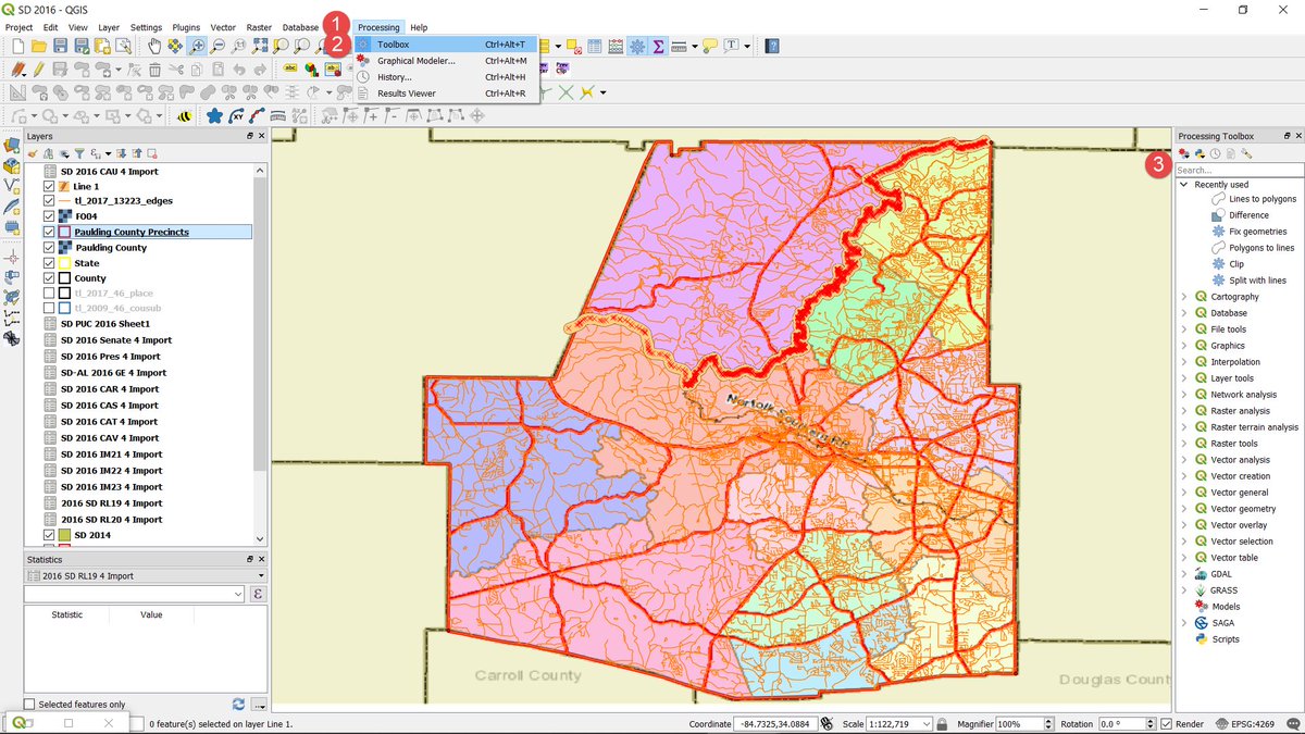
@elium2 The "Split by Line" tool & Click on it. A dialog will pop up. 1) Change the input layer to the layer you want to cut - here Paulding County Precinct. 2) Change the split layer to the line you want to cut it with. Here, Line 1. 3) Hit OK.
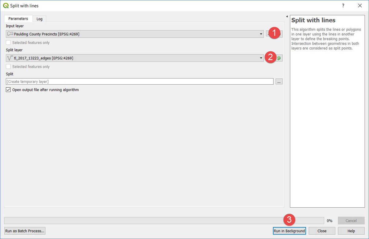
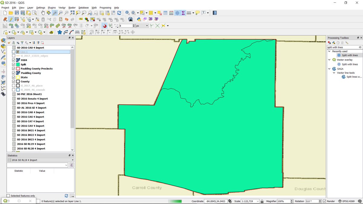
@elium2 Actually, run in background. QGIS will then try to split the layer by the line. If you've done everything correctly, you'll now have 2 polygons in a new layer called "Split". It should look like this:
@elium2 We'll probably need to add a precinct name and GEOID column to the data eventually. And there's a lot more to this, which I'll go into tomorrow if there's interest. For example, sometimes, the splits will create very small polygons that need to be merged into the larger ones.