
#Hydronomastics is the study of #hydronyms, the proper names of bodies of water.
It's a branch of #toponomastics, the study of #toponyms (the proper names of places), which in turn is a branch of #onomastics, the study of #orthonyms (proper names).
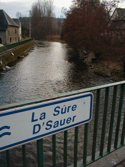
French / Luxembourghish sign:
It's a branch of #toponomastics, the study of #toponyms (the proper names of places), which in turn is a branch of #onomastics, the study of #orthonyms (proper names).
French / Luxembourghish sign:
#Hydronym and #hydronomastics both derive from Ancient #Greek ὕδωρ / húdōr (water) + ὄνομα / ónoma (name).

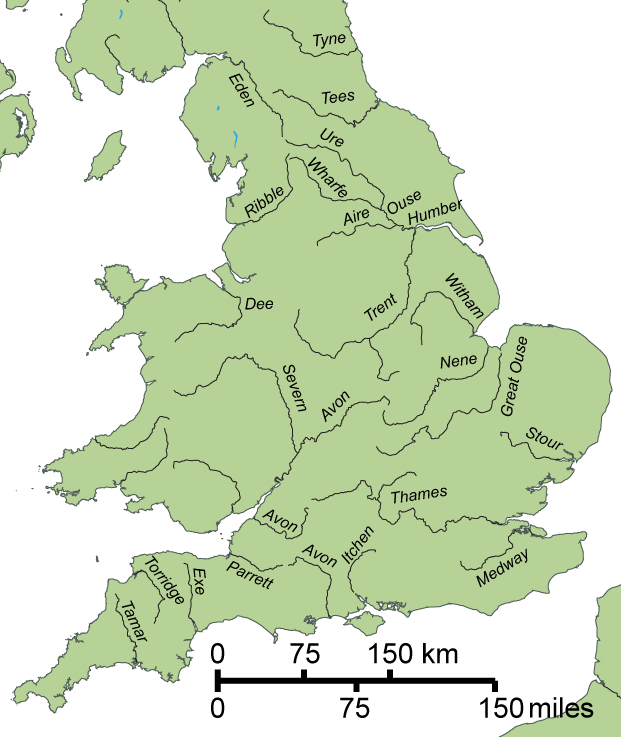
#Hydronyms tend to outlast other #toponyms, even when new #languages and cultures displace earlier ones.
#England, #EastAnglia, #Essex, and #Sussex are named for the #Angles and #Saxons; but #Trent, #Ouse, #Thames, #Severn, and #Avon are older #Celtic and #RomanoBritish names.
#England, #EastAnglia, #Essex, and #Sussex are named for the #Angles and #Saxons; but #Trent, #Ouse, #Thames, #Severn, and #Avon are older #Celtic and #RomanoBritish names.
The word #ocean derives from #Oceanus ( Ὠκεανός / Ōkeanós in #AncientGreek), the eldest of the Titans from #Greek #mythology.
Some Greeks, including #Anaximander and #Hecataeus of #Miletus, depicted Oceanus as an enormous river that encircled the entire world.
Some Greeks, including #Anaximander and #Hecataeus of #Miletus, depicted Oceanus as an enormous river that encircled the entire world.

The Finnish word for #ocean is #valtameri, coined by writer Reinhold von Becker (1788–1858), a historian of the #Finnish #language.
The Proto-#Finnic words *valta (main / might) and *meri (sea) were both borrowings from #IndoEuropean #languages.
The Proto-#Finnic words *valta (main / might) and *meri (sea) were both borrowings from #IndoEuropean #languages.

The word #sea has #Germanic roots.
Most bodies of water with 'Sea' in their #English names (eg the #IrishSea) are extensions of the ocean. A few salt lakes are also named 'Sea': #CaspianSea, #AralSea, #DeadSea, #SaltonSea.
Uniquely, the 'Sea' of #Galilee is a freshwater lake.
Most bodies of water with 'Sea' in their #English names (eg the #IrishSea) are extensions of the ocean. A few salt lakes are also named 'Sea': #CaspianSea, #AralSea, #DeadSea, #SaltonSea.
Uniquely, the 'Sea' of #Galilee is a freshwater lake.

The #Dutch word for 'sea' is 'zee': #Noordzee (#NorthSea).
The #TappanZee is a wide part of the #HudsonRiver estuary in the state of #NewYork, formerly part of the Dutch colony of #NewNetherland. The #Tappan people were a subgroup of the #Lenape people.
The #TappanZee is a wide part of the #HudsonRiver estuary in the state of #NewYork, formerly part of the Dutch colony of #NewNetherland. The #Tappan people were a subgroup of the #Lenape people.

The masculine #German noun See means 'lake': der #Bodensee (#LakeConstance).
The feminine noun See means 'sea': die #Nordsee (the #NorthSea).
Another word for 'sea' is the neuter noun Meer: das #Mittelmeer (the #Mediterranean Sea).
The German word for 'ocean' is (der) Ozean.
The feminine noun See means 'sea': die #Nordsee (the #NorthSea).
Another word for 'sea' is the neuter noun Meer: das #Mittelmeer (the #Mediterranean Sea).
The German word for 'ocean' is (der) Ozean.

The reconstructed #ProtoIndoEuropean word *móri (sea, lake) is the root of many watery words in #English (eg: marine, mermaid) and in other #languages:
#Ukrainian: more (sea)
#Latin: mare (sea)
#Irish: muir (sea)
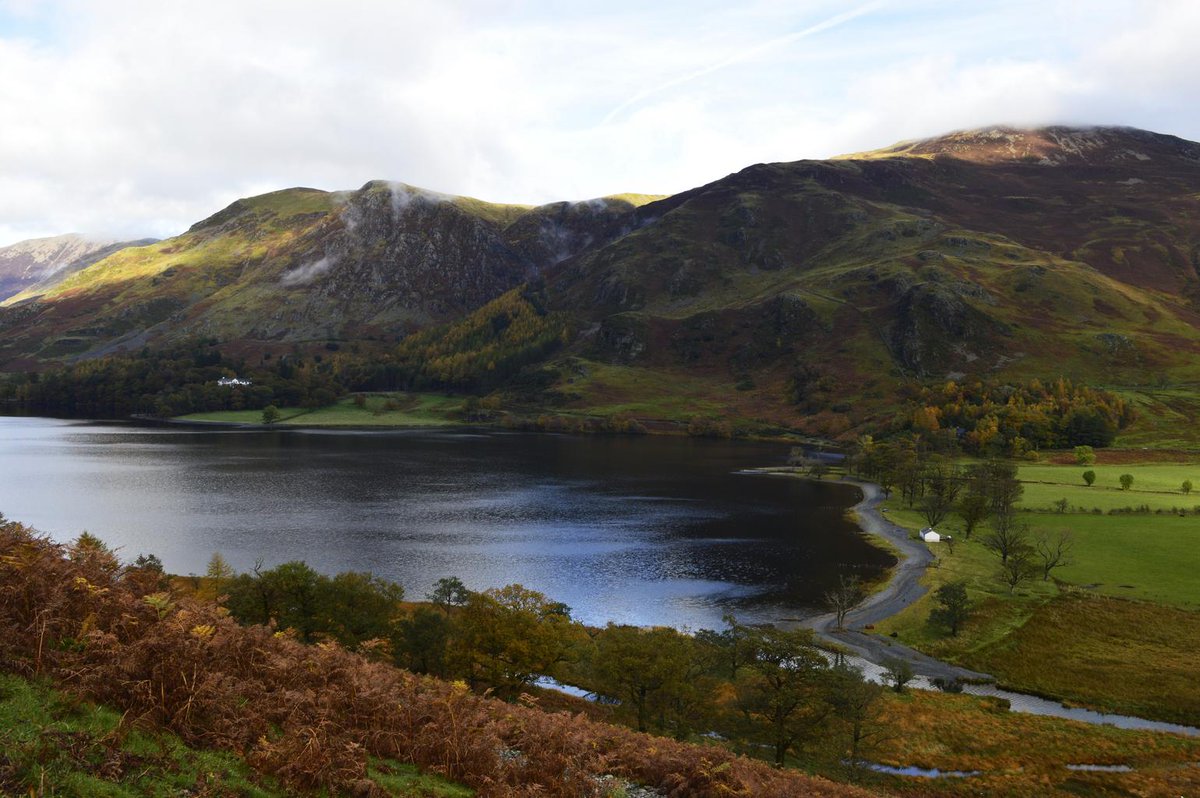
A few lakes in #Cumbria are named 'mere', including #Buttermere:
#Ukrainian: more (sea)
#Latin: mare (sea)
#Irish: muir (sea)
A few lakes in #Cumbria are named 'mere', including #Buttermere:
Old #Norse sær (sea) has the same #Germanic root as #English sea, #Dutch zee, and #German See.
Sjór and sjár are later forms of sær, whose modern descendants include #Norwegian sjø, #Faroese sjógvur, #Danish sø, and #Swedish sjö.
#KlaraSjö (#LakeKlara) is a canal in #Stockholm:
Sjór and sjár are later forms of sær, whose modern descendants include #Norwegian sjø, #Faroese sjógvur, #Danish sø, and #Swedish sjö.
#KlaraSjö (#LakeKlara) is a canal in #Stockholm:

The #ProtoGermanic word *habą (ocean, sea) became haf in #OldNorse and #Icelandic, and hav in #Norwegian, #Danish, and #Swedish: Ålands hav (Sea of #Åland).
It comes from an #IndoEuropean root meaning seize or lift, which also gave us #English 'heavy' and #German 'Hefe' (yeast).
It comes from an #IndoEuropean root meaning seize or lift, which also gave us #English 'heavy' and #German 'Hefe' (yeast).

The earliest known use of the phrase 'the Seven Seas' was around 2300 BCE in the #Mesopotamian city of #Ur by the #Sumerian poet and High Priestess #Enheduanna. She was the daughter of #Sargon of #Akkad, and is probably the world's first author whose name has been recorded.

The phrase 'the Seven Seas' appears in numerous cultures throughout history (#Mesopotamian, #Chinese, #Hindu, etc), but with a different meaning each time. The #Persians applied the name to the tributaries of the #Oxus River (present-day #AmuDarya) in #Bactria, #CentralAsia.

The #Phoenicians established colonies and trading routes throughout the #Mediterranean, the parts of which constituted their notion of 'the Seven Seas': #Aegean, #Ionian, #Adriatic, #Tyrrhenian, #Ligurian, #Balearic, and #Alboran.
An #Assyrian relief depicting #Phoenician ships:
An #Assyrian relief depicting #Phoenician ships:

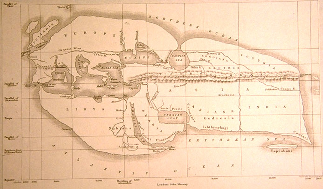
#AncientGreek writers' list of the #SevenSeas reveals the extent of their #geographic knowledge. It includes the #Aegean, #Adriatic, #Mediterranean, Black, Red, and #Caspian seas, as well as the #PersianGulf.
19th-century reconstruction of #Eratosthenes' map of the known world:
19th-century reconstruction of #Eratosthenes' map of the known world:
In 77 CE, #Pliny the Elder published Natural History, in which he described a group of salt-water lagoons known as 'the Seven Seas', situated near the mouth of the river Po .
Centuries' worth of silt deposits have since created land where the ancient lagoons once lay.
Centuries' worth of silt deposits have since created land where the ancient lagoons once lay.

#Etruscans settled the town of #Atria (present-day #Adria) in the 12th century BCE. It was a port town before the Po's silt deposits left it landlocked. #Pliny wrote that Atria 'gave the name of Atriatic to the sea now called the #Adriatic'. Today Adria is more than 20km inland.

The 9th-century #geographer Abu Abbas Al-Ya'qubi documented 'the Seven Seas' that #mediaeval #Arab traders traversed en route to #China:
#PersianGulf
#ArabianSea
#BayOfBengal
#StraitOfMalacca
#SingaporeStrait
#GulfOfThailand
#SouthChinaSea
A traditional #dhow with two masts:
#PersianGulf
#ArabianSea
#BayOfBengal
#StraitOfMalacca
#SingaporeStrait
#GulfOfThailand
#SouthChinaSea
A traditional #dhow with two masts:

Since the 19th century 'the Seven Seas' has usually referred to the major parts of the world's oceans:
#Arctic
North #Atlantic
South Atlantic
#Indian
North #Pacific
South Pacific
#Antarctic (or Southern)
A sacred number in antiquity, 'seven' strikes today's reader as arbitrary.
#Arctic
North #Atlantic
South Atlantic
#Indian
North #Pacific
South Pacific
#Antarctic (or Southern)
A sacred number in antiquity, 'seven' strikes today's reader as arbitrary.

The #ArcticOcean is the smallest of the oceans. It's sometimes considered part of the #AtlanticOcean.
'#Arctic' comes from #Greek ἀρκτικός / arktikos (bear), referring either to #UrsaMajor (the Great Bear) or #UrsaMinor (the Little Bear). Both are northern #constellations.
'#Arctic' comes from #Greek ἀρκτικός / arktikos (bear), referring either to #UrsaMajor (the Great Bear) or #UrsaMinor (the Little Bear). Both are northern #constellations.

Some antique maps refer to the #ArcticOcean as the 'Northern Ocean' (Oceanus Septentrionalis in #Latin), including this late-17th-century map of the #NovayaZemlya archipelago by #Dutch #cartographer Johannes #vanKeulen. The sea ice is labelled 'Mare Glaciale'.

#French Navy officer and #hydrographer Charles Pierre Claret de #Fleurieu gave the #ArcticOcean the name 'Mar Glaciale Artico' in 1797.
The Royal #Geographical Society in London adopted the name '#Arctic Glacial Ocean' in 1845.
The Royal #Geographical Society in London adopted the name '#Arctic Glacial Ocean' in 1845.

The #BarentsSea lies north of the #KolaPeninsula between the #Svalbard archipelago and European #Russia. It's named for Willem #Barentsz (~1550–1597), a #Dutch explorer who died on his third attempt to find a Northeast Passage to #Asia.
A 1601 map of Barentsz's first voyage:
A 1601 map of Barentsz's first voyage:

#Mediaeval #Russians called the #BarentsSea the '#Murman Sea'. The #Russian word múrmane (#Norwegians) probably derives from Old #Norse norðmaðr (#Norseman).
#Му́рманск / #Murmansk is a city on the #MurmanCoast, an area of the #KolaPeninsula previously inhabited by Norwegians.
#Му́рманск / #Murmansk is a city on the #MurmanCoast, an area of the #KolaPeninsula previously inhabited by Norwegians.

The #WhiteSea (#Белоеморе / Béloye móre in #Russian) is an inlet of the #BarentsSea in northwestern #Russia. The name White may refer to sea ice. Or it may be part of a wider tendency to describe seas as white. For example, South #Slavs call the #AegeanSea the 'White Sea'.

The modern name of the #WhiteSea started to appear on maps during the late 16th century. Before then the local #Pomor #Russians and #Karelian people called it the #Kanda Bay, a name that may derive from the #KaninPeninsula, which flanks the White Sea's entrance to the northeast.

The ancient name '#Kanda' still appears in Kandalaskha, a variant of #Kannanlakši, which means 'Kanda Bay' in the #Finnic #Karelian #language.
#Кандала́кша / #Kandalaksha is a town on the #KandalakshaGulf, the northwestern arm of the #WhiteSea.
[Image: commons.wikimedia.org/wiki/File:%D0%…]
#Кандала́кша / #Kandalaksha is a town on the #KandalakshaGulf, the northwestern arm of the #WhiteSea.
[Image: commons.wikimedia.org/wiki/File:%D0%…]

The #Scandinavian version of '#KandaBay' is 'Gandvík' ('vík' = 'bay'), described in #Norse #mythology as a dangerous sea.
The 1394 #Icelandic manuscript #Flateyjarbók names the #WhiteSea Gandvík. (In other sources #Gandvík might refer to the #GulfOfBothnia in the #BalticSea.)
The 1394 #Icelandic manuscript #Flateyjarbók names the #WhiteSea Gandvík. (In other sources #Gandvík might refer to the #GulfOfBothnia in the #BalticSea.)

The White Sea's current name in #Finnish and in #Karelian is #Vienanmeri (Dvina Sea). The #NorthernDvina River empties into the #WhiteSea's southeastern #DvinaBay at #Arkhangelsk. '#Dvina' may derive from a #ProtoIndoEuropean word for 'river'.
[Image: en.wikipedia.org/wiki/File:Seve…]
[Image: en.wikipedia.org/wiki/File:Seve…]

#OnegaBay is the southernmost arm of the #WhiteSea. The town of #Onega sits at the mouth of the #OnegaRiver. (Nearby #LakeOnega is a separate body of water in the #BalticSea basin.)
The name 'Onega' is thought to be related to #Finnish 'Enojoki' (main river).
The Onega River:
The name 'Onega' is thought to be related to #Finnish 'Enojoki' (main river).
The Onega River:

The narrow strait at the entrance to the #WhiteSea is the #Gorlo, #Russian for 'throat'.
#MezenBay, the mouth of the #MezenRiver, sits beside it. '#Mezen' may be related to a word for 'river' from the #Permic branch of the #Uralic #languages.
[Image: en.wikipedia.org/wiki/White_Sea…]
#MezenBay, the mouth of the #MezenRiver, sits beside it. '#Mezen' may be related to a word for 'river' from the #Permic branch of the #Uralic #languages.
[Image: en.wikipedia.org/wiki/White_Sea…]

The southeastern corner of the #BarentsSea is called the #PechoraSea. #Europe's sixth longest river, the #PechoraRiver, flows into the sea's southern #PechoraBay.
The river is named for the many caves near it. #Pechora is a variant of the #Russian word for 'cave'.
The river is named for the many caves near it. #Pechora is a variant of the #Russian word for 'cave'.

In his 1840 novel 'A Hero of Our Time', Mikhail #Lermontov named his protagonist #Pechorin after the #Pechora River.
It was an homage to Alexander #Pushkin's work 'Eugene Onegin', whose eponymous protagonist was named for the #Onega River.
Pushkin's 1830 portrait of #Onegin:
It was an homage to Alexander #Pushkin's work 'Eugene Onegin', whose eponymous protagonist was named for the #Onega River.
Pushkin's 1830 portrait of #Onegin:

The Jackson-Harmsworth expedition (1894–97) was based on the misconception that #FranzJosefLand extended to the #NorthPole. The discovery of the #QueenVictoriaSea to the north dashed their hopes of reaching the Pole by sledge.
The expedition also discovered the #BritishChannel.
The expedition also discovered the #BritishChannel.

The #AustroHungarian #NorthPole expedition (1872–74) named the #AustrianStrait and #FranzJosefLand after #Austria and its emperor.
They named #MarkhamSound after #British explorer #AlbertHastingsMarkham (the designer of #NewZealand's flag 🇳🇿).
[Image: en.wikipedia.org/wiki/File:Map_…]
They named #MarkhamSound after #British explorer #AlbertHastingsMarkham (the designer of #NewZealand's flag 🇳🇿).
[Image: en.wikipedia.org/wiki/File:Map_…]

The #KaraSea is part of the #ArcticOcean east of the #BarentsSea. It's named for the #KaraRiver, which flows from #Russia's Pay-Khoy Ridge into #Baydaratskaya Bay.
'#Kara' derives from a word meaning 'hummocked / mounded ice' in the #Nenets branch of the #Uralic #languages.
'#Kara' derives from a word meaning 'hummocked / mounded ice' in the #Nenets branch of the #Uralic #languages.

Some antique maps label the #KaraSea the '#Scythian Ocean', owing to #Greek accounts placing the #Scythians near the northern edge of the world.
Some also use '#TabinSea' based on a reference by the #Roman author #Pliny the Elder in book VI of his 'Natural History'.
1606 map:
Some also use '#TabinSea' based on a reference by the #Roman author #Pliny the Elder in book VI of his 'Natural History'.
1606 map:

The #MatochkinStrait (#MatochkinShar) bisects the #NovayaZemlya archipelago in #Russia. It lies near the nuclear test site where the most powerful explosive in history was detonated in 1961.
The name #Matochkin is related to the #Pomor #Russian words for 'mother' and 'uterus'.
The name #Matochkin is related to the #Pomor #Russian words for 'mother' and 'uterus'.

The #Yugorsky (#Yugor) Strait lies at the northwestern tip of the #YugorskyPeninsula.
#Yugra (or #Yugrian) was a collective name for the nearby #Uralic-speaking peoples. It may be the origin of the name '#Hungarian'. (Alternatively, the name 'Hungarian' may have #Turkic roots.)
#Yugra (or #Yugrian) was a collective name for the nearby #Uralic-speaking peoples. It may be the origin of the name '#Hungarian'. (Alternatively, the name 'Hungarian' may have #Turkic roots.)

The #GulfOfOb on the #KaraSea is the world's longest estuary.
The Russian name of the river #Ob is #Обь / Obʹ, possibly from #ProtoIndoIranian *Hā́p-, meaning 'river' or 'water'.
A 1745 map showing the Gulf of Ob (#О́бскаягуба́ / #ObskayaGuba in #Russian):
The Russian name of the river #Ob is #Обь / Obʹ, possibly from #ProtoIndoIranian *Hā́p-, meaning 'river' or 'water'.
A 1745 map showing the Gulf of Ob (#О́бскаягуба́ / #ObskayaGuba in #Russian):

For centuries #Russians collectively referred to the Khanty and some other #Uralic-speaking #Indigenous groups as '#Yugra'.
From the 16th century they used another (now obsolete) collective term, '#Ostyak', which derived from 'As', the #Khanty name for the River #Ob.
From the 16th century they used another (now obsolete) collective term, '#Ostyak', which derived from 'As', the #Khanty name for the River #Ob.

Until the 1930s the #Uralic-speaking #Selkup people were known to #Russians as 'Ostyak-Samoyeds'.
'#Ostyak' was also used to refer to the #Ket people, whose #language is the only surviving member of the endangered #Yeniseian language family.
[Image: en.wikipedia.org/wiki/File:Yeni…]
'#Ostyak' was also used to refer to the #Ket people, whose #language is the only surviving member of the endangered #Yeniseian language family.
[Image: en.wikipedia.org/wiki/File:Yeni…]

The #Yeniseian #language family is named for the #YeniseyRiver, the largest river system that drains into the #ArcticOcean. It flows into the #YeniseyGulf in the #KaraSea.
The name #Yenisey (#Yenisei) is either #Tungusic, from the #Evenki language; or #Turkic, from Old #Kyrgyz.
The name #Yenisey (#Yenisei) is either #Tungusic, from the #Evenki language; or #Turkic, from Old #Kyrgyz.

The names of the #Tungusic #language family, the #TunguskaPlateau, and the #LowerTunguska and Stony #Tunguska tributaries of the #YeniseyRiver are all based on 'Tongus', a historic name used by the #Turkic #Yakut people to refer to the Tungusic #Evenki people.
1882 drawing:
1882 drawing:

The name '#Baikal' is either #Turkic or #Mongolic in origin.
#LakeBaikal is the world's biggest (by volume), deepest, and oldest lake. It feeds the #AngaraRiver, a branch of the #Yenisey. Like a few other tributaries, the lower part of the #Angara used to be called #Tunguska.
#LakeBaikal is the world's biggest (by volume), deepest, and oldest lake. It feeds the #AngaraRiver, a branch of the #Yenisey. Like a few other tributaries, the lower part of the #Angara used to be called #Tunguska.

#Norwegian explorer #FridtjofNansen named the #KaraSea's #TollBay after Eduard von Toll, a #BalticGerman geologist who explored the bay during his 1900–1902 #RussianArcticExpedition to find #SannikovLand, a phantom island in the #ArcticOcean. Toll vanished and was never found.

#MiddendorffBay in the #KaraSea is named after Alexander von #Middendorff (1815–1894), a #BalticGerman-#Estonian zoologist and explorer from #SaintPetersburg, #Russia.
The #Kodiak brown bear's #Latin name, Ursus arctos middendorffi, is also named in Middendorff's honour.
The #Kodiak brown bear's #Latin name, Ursus arctos middendorffi, is also named in Middendorff's honour.

The #KaraSea's #ZhuravlevBay was named after Sergei Prokopyevich #Zhuravlev (1892–1937), a #Soviet #Arctic explorer and surveyor.
It lies west of #Komsomolets Island, which was named for the members of the #Komsomol, the youth division of the #SovietUnion's Communist Party.
It lies west of #Komsomolets Island, which was named for the members of the #Komsomol, the youth division of the #SovietUnion's Communist Party.

During their 1930–32 expedition #Soviet explorers Georgy #Ushakov and Nikolay #Urvantsev named most features of the #SevernayaZemlya ('Northern Land') archipelago in honour of the #RussianRevolution.
#RedArmyStrait lies between #KomsomoletsIsland and #OctoberRevolutionIsland.
#RedArmyStrait lies between #KomsomoletsIsland and #OctoberRevolutionIsland.

Prior to WWII, the #YunyStrait between #Komsomolets Island and #PioneerIsland was named 'Proliv Yungshturm' after the Roter Jungsturm (Red Young Storm), the youth wing of the #RoterFrontkämpferbund (Alliance of Red Front-Fighters), a 1920s #German #Communist paramilitary group.

#ShokalskyStrait separates #Bolshevik and #OctoberRevolution islands in the Far North of #Russia.
It's named for Yuly #Shokalsky (1856–1940), a #Russian #oceanographer who emphasised the link between marine phenomena and global climate changes. He coined the term 'World Ocean'.
It's named for Yuly #Shokalsky (1856–1940), a #Russian #oceanographer who emphasised the link between marine phenomena and global climate changes. He coined the term 'World Ocean'.

The #LaptevSea is part of the #ArcticOcean east of the #KaraSea.
It's named for the #Russian naval officers and #Arctic explorers Khariton Laptev (1700–1763) and Dmitry #Laptev (1701–1771), who were cousins.
It's named for the #Russian naval officers and #Arctic explorers Khariton Laptev (1700–1763) and Dmitry #Laptev (1701–1771), who were cousins.

The #LaptevSea went by various names over the centuries, including the #Tartar Sea, the #Lena Sea, the #Siberian Sea, and the Icy Sea.
From 1893 to 1935 it was named the #NordenskjöldSea, after the #Finnish-#Swedish scientist and #Arctic explorer Nils Adolf Erik #Nordenskiöld.
From 1893 to 1935 it was named the #NordenskjöldSea, after the #Finnish-#Swedish scientist and #Arctic explorer Nils Adolf Erik #Nordenskiöld.

#KrenkelBay is an arm of the #LaptevSea in #Komsomolets Island, #Russia.
It's named after Ernst #Krenkel (1895–1978), a #Soviet #Arctic explorer who set a world record in long-distance #radio communication in 1930 by establishing a link between #FranzJosefLand and #Antarctica.
It's named after Ernst #Krenkel (1895–1978), a #Soviet #Arctic explorer who set a world record in long-distance #radio communication in 1930 by establishing a link between #FranzJosefLand and #Antarctica.

#Soviet explorers Georgy #Ushakov and Nikolay #Urvantsev mapped two fjords on the east coast of #OctoberRevolutionIsland in 1931.
#MatusevichFjord was named after #Arctic researcher Nikolai #Matusevich, and #MaratFjord after Jean-Paul #Marat, a martyr of the #FrenchRevolution.
#MatusevichFjord was named after #Arctic researcher Nikolai #Matusevich, and #MaratFjord after Jean-Paul #Marat, a martyr of the #FrenchRevolution.

The same expedition that put #MatusevichFjord and #MaratFjord on the map also named #MikoyanBay, located on the northeastern coast of #BolshevikIsland.
Anastas #Mikoyan (1895–1978) was a #Communist politician from #Armenia and the longest-serving member of the #Soviet Politburo.
Anastas #Mikoyan (1895–1978) was a #Communist politician from #Armenia and the longest-serving member of the #Soviet Politburo.

'#Faddey' is #Russian for '#Thaddeus'.
Some sources state that Khariton #Laptev named the #LaptevSea's #FaddeyBay in 1739 after Saint Thaddeus.
Others claim that Boris #Vilkitski named it in 1913 after Fabian Gottlieb Thaddeus von #Bellingshausen, the discoverer of #Antarctica.
Some sources state that Khariton #Laptev named the #LaptevSea's #FaddeyBay in 1739 after Saint Thaddeus.
Others claim that Boris #Vilkitski named it in 1913 after Fabian Gottlieb Thaddeus von #Bellingshausen, the discoverer of #Antarctica.
#MariaPronchishcheva Bay, located on the east coast of the #Taymyr Peninsula in #Russia, is named in honour of the first female polar explorer. Sadly, she and her husband, Vasili #Pronchishchev, died of scurvy in 1736 while returning from an expedition to the peninsula.

The #KhatangaRiver in northern #Siberia flows into the Khatanga Gulf, a tidal estuary on the #LaptevSea. #Khatanga means 'large water' in the local #Evenki #language.
An 1882 depiction of #Preobrazheniya Island in the #KhatangaGulf:
An 1882 depiction of #Preobrazheniya Island in the #KhatangaGulf:

#KozhevnikovBay, an eastern offshoot of the #KhatangaGulf, is named in honour of Mikhail Yakovlevich #Kozhevnikov (1870–1942), a member of the #Khatanga expedition who mapped the bay in 1905, along with many other nearby features.
The bay as shown in a 1938 Red Army atlas:
The bay as shown in a 1938 Red Army atlas:

#NordvikBay is located on the #LaptevSea east of the #KhatangaGulf. It was discovered and named in 1739 by the Great Northern Expedition, a #Russian expedition led by #Danish cartographer and explorer Vitus #Bering.
'#Nordvik' means 'North Bay' in the North #Germanic #languages.
'#Nordvik' means 'North Bay' in the North #Germanic #languages.

The #LaptevSea's #AnabarBay is the mouth of the #AnabarRiver, and the easternmost fjord in #Russia.
'#Anabar' is believed to derive from 'anu', a word for 'water' in the #Indigenous Tundra #Yukaghir #language, possibly combined with the #Evenki word 'byr', also meaning 'water'.
'#Anabar' is believed to derive from 'anu', a word for 'water' in the #Indigenous Tundra #Yukaghir #language, possibly combined with the #Evenki word 'byr', also meaning 'water'.

The #OlenyokRiver (#Оленёк or #OlenekRiver) in #Siberia empties into #OlenyokGulf (also known as #OlenekBay) on the #LaptevSea.
Olénʹ is the #Russian word for 'deer'.
[Image: commons.wikimedia.org/wiki/File:Olen…]
Olénʹ is the #Russian word for 'deer'.
[Image: commons.wikimedia.org/wiki/File:Olen…]

The #Lena is the longest river in #Russia. It flows into the #Laptev Sea.
#Russian explorer Demid #Pyanda first recorded the name in 1623 as 'Eluene', from the #Evenki 'Elyu-Ene' meaning 'the Large River'.
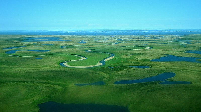
False-colour composite satellite image of the #LenaRiver delta:
#Russian explorer Demid #Pyanda first recorded the name in 1623 as 'Eluene', from the #Evenki 'Elyu-Ene' meaning 'the Large River'.
False-colour composite satellite image of the #LenaRiver delta:

In 1897 Vladimir Ilyich Ulyanov was arrested for sedition and exiled to #Siberia for three years. The Marxist revolutionary first adopted the pseudonym '#Lenin' in 1901, possibly based on the #Lena River.

The #KutaRiver is a tributary of the Lena. Kuta means 'peat bog' in #Evenki.
The former coat of arms of the #Siberian town of #UstKut (Усть-Кут, #Russian for 'mouth of the Kuta') depicts the confluence of the #Kuta and #Lena rivers in the shape of the #Cyrillic letter У:
The former coat of arms of the #Siberian town of #UstKut (Усть-Кут, #Russian for 'mouth of the Kuta') depicts the confluence of the #Kuta and #Lena rivers in the shape of the #Cyrillic letter У:

The #Olyokma River is a tributary of the #LenaRiver in #Russia. Its name supposedly comes from an #Evenki phrase that means 'rich in squirrels'.
The river is called Өlүөkhүme in the #Turkic #Yakut #language.
[Image: commons.wikimedia.org/wiki/File:Olyo…]
The river is called Өlүөkhүme in the #Turkic #Yakut #language.
[Image: commons.wikimedia.org/wiki/File:Olyo…]

The #SinyayaRiver is a tributary of the #Lena in #Yakutia, #Russia. (The #Velikaya River in #Belarus also has a tributary called #Sinyaya.)
The name is Russian for 'deep blue'. #Russian uses a different word for light blue: golubój.
[Image: upload.wikimedia.org/wikipedia/comm…]
The name is Russian for 'deep blue'. #Russian uses a different word for light blue: golubój.
[Image: upload.wikimedia.org/wikipedia/comm…]

#SannikovStrait, named after explorer Yakov #Sannikov, separates the #Lyakhovsky Islands from the Anzhu Islands in the Russian #Arctic.
The #Anzhu Islands are named after #Russian explorer Pyotr Anjou, a descendant of Protestant refugees from the French province of #Anjou.
The #Anzhu Islands are named after #Russian explorer Pyotr Anjou, a descendant of Protestant refugees from the French province of #Anjou.

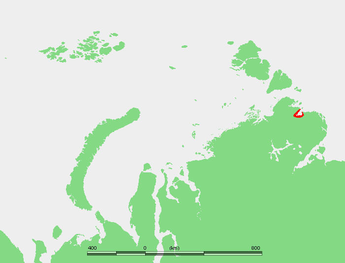
The #EastSiberianSea is part of the #ArcticOcean north of eastern Siberia, for which it's named.
The #etymology of '#Siberia' is unconfirmed. There are various hypotheses, including possible #Turkic origins meaning 'sleeping land', 'beautiful', or 'water + wild forest'.
The #etymology of '#Siberia' is unconfirmed. There are various hypotheses, including possible #Turkic origins meaning 'sleeping land', 'beautiful', or 'water + wild forest'.

#Yakut and some other Turkic #languages have words for 'blizzard' or 'snowstorm' that bear similarity to the name '#Siberia', offering another #Turkic possibility for the source of the region's name.
Snowstorm in the #Siberian city of #Yakutsk:
[Image: commons.wikimedia.org/wiki/File:Yaku…]
Snowstorm in the #Siberian city of #Yakutsk:
[Image: commons.wikimedia.org/wiki/File:Yaku…]

The #Mongolian word 'shibir', referring to a swampy area full of birch trees, has also been suggested as the origin of the name '#Siberia'.
A map of northeastern Asia drawn by Johann Treskot in 1776:
A map of northeastern Asia drawn by Johann Treskot in 1776:

Some think '#Siberia' is a Russification of Sibe (also #Xibe or #Xibo), an ethnic group of ~190K people in #China.
#Sibe belongs to the Southern branch of the #Tungusic #languages. It's mutually intelligible with #Manchu.
An 1882 drawing entitled '#Sibo military colonists':
#Sibe belongs to the Southern branch of the #Tungusic #languages. It's mutually intelligible with #Manchu.
An 1882 drawing entitled '#Sibo military colonists':

#Siberia may be named for the Sirtya (#Sihirta), who — according to Nenets tradition — were blond, blue-eyed, supernatural people who lived underground and herded mammoths.
Bone / antler figurines of #Sirtya, by #Nenets artist Evgeniy Salinder:
[Image: circumarctic.com/salinder]
Bone / antler figurines of #Sirtya, by #Nenets artist Evgeniy Salinder:
[Image: circumarctic.com/salinder]

Stories about the #Sirtya may be based on the pre-historic people who lived in northwestern #Siberia when the #Nenets arrived in the 1st millennium BCE.
The Iron-Age Ust’-Polui culture (yellow on map) presumably spoke a Paleo-Siberian #language.
[Image: commons.wikimedia.org/wiki/File:%D0%…]
The Iron-Age Ust’-Polui culture (yellow on map) presumably spoke a Paleo-Siberian #language.
[Image: commons.wikimedia.org/wiki/File:%D0%…]

#RussianGeographicalSociety chairman Yuly #Shokalsky proposed the name '#EastSiberianSea'. The #USSR made it official in 1935.
Before then the sea had various names, including 'Icy', 'Northern', '#Siberian', and 'Indigirskoe' (after the #IndigirkaRiver).
Before then the sea had various names, including 'Icy', 'Northern', '#Siberian', and 'Indigirskoe' (after the #IndigirkaRiver).
https://twitter.com/linglore/status/1386321481521500165
The #Indigirka River in eastern #Russia flows north to the #EastSiberianSea. Its name means 'people of the Indi clan' in Even, an endangered northern #Tungusic #language closely related to #Evenki.
Even women in traditional dress, photographed in the early 20th century:
Even women in traditional dress, photographed in the early 20th century:

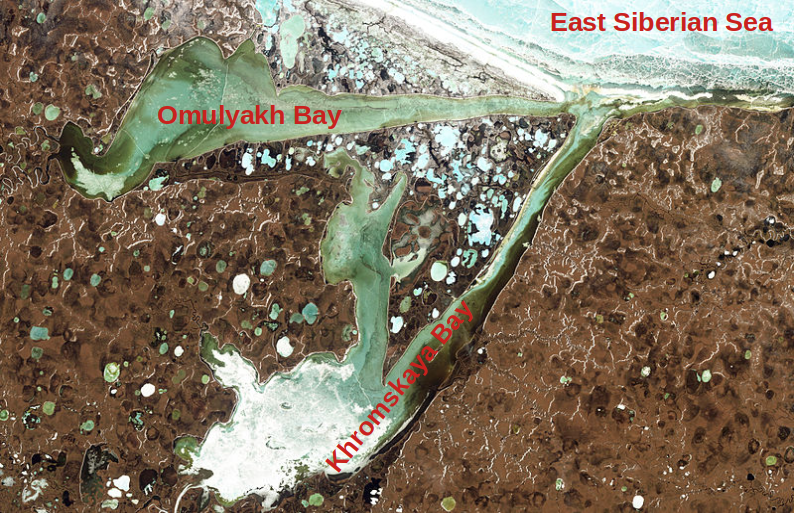
The #KhromaRiver in #Siberia empties into #KhromskayaBay. '#Khroma' means 'chrome' in #Russian.
#Omulyakh Bay and #Khromskaya Bay are two bays that share the same mouth on the #EastSiberiaSea, forming a wedge shape.
#Omulyakh Bay and #Khromskaya Bay are two bays that share the same mouth on the #EastSiberiaSea, forming a wedge shape.
The #Alazeya River flows into the #KolymaBay on the #EastSiberianSea.
The name comes from the Alayi people, a subgroup of the #Indigenous Yukaghir people of northeastern #Siberia. The #Yukaghir language family is one of the world's primary #language families.
The name comes from the Alayi people, a subgroup of the #Indigenous Yukaghir people of northeastern #Siberia. The #Yukaghir language family is one of the world's primary #language families.

A few centuries ago the #Yukaghir languages spread across much of northeastern #Siberia. Today, only two of the #languages survive, with fewer than 130 speakers between them. The #Omok and #Chuvan varieties became extinct around the 18th century.
[Image: en.wikipedia.org/wiki/File:Yuka…]
[Image: en.wikipedia.org/wiki/File:Yuka…]

#KolymaBay and #KolymaGulf are separate areas of the #EastSiberianSea 330km apart. The #KolymaRiver flows into the gulf. (The bay is named for the #KolymaLowland.)
'#Kolyma' derives from the Tundra #Yukaghir name 'kulumaa', meaning 'river'.
[Image: commons.wikimedia.org/wiki/File:%D0%…]
'#Kolyma' derives from the Tundra #Yukaghir name 'kulumaa', meaning 'river'.
[Image: commons.wikimedia.org/wiki/File:%D0%…]

A map of the #Kolyma's tributaries.
#Ozhogina is named after #Russian explorer Ivan #Ozhogi, who died there in the 17th century.
#Balygychan comes from a #Yakut word for 'small fish'.
#Omolon refers to the Omol ('good') clan of the #Yukaghir.
[Image: en.wikipedia.org/wiki/File:Koly…]
#Ozhogina is named after #Russian explorer Ivan #Ozhogi, who died there in the 17th century.
#Balygychan comes from a #Yakut word for 'small fish'.
#Omolon refers to the Omol ('good') clan of the #Yukaghir.
[Image: en.wikipedia.org/wiki/File:Koly…]

The name of the #Rauchua River in northeastern #Siberia comes from the #Indigenous Chukchi #language.
It may derive from 'Ravchivan', which means 'the place after defeating the camp', probably referring to 19th-century clashes between #Chuckchi and #Yukaghir or Even groups.
It may derive from 'Ravchivan', which means 'the place after defeating the camp', probably referring to 19th-century clashes between #Chuckchi and #Yukaghir or Even groups.

The #EastSiberianSea's #ChaunskayaBay is named after the #ChaunRiver that flows into it. '#Chaun' comes from the Even word 'chaan' meaning 'distant'.
Until the middle of the 18th century, #Cossack settlers called the river 'Kovycha'.
Until the middle of the 18th century, #Cossack settlers called the river 'Kovycha'.

The name of the #Palyavaam, a tributary of the #ChaunRiver, comes from #Yukagir 'pielle-vaam' ('mountain river').
Many of its tributaries have #Chukchi names:
#Kookwyn ('deep place')
#Vykvylvegyrgyn ('a river cutting through stones')
#Elkakvun, from 'Ylkakvyn' ('mushroom stone')
Many of its tributaries have #Chukchi names:
#Kookwyn ('deep place')
#Vykvylvegyrgyn ('a river cutting through stones')
#Elkakvun, from 'Ylkakvyn' ('mushroom stone')

The name of the #Ichvuveyem River (highlighted on map) comes from a #Chukchi word meaning 'a river with rich pastures'.
To its north, on the coast of the #EastSiberianSea, is a lagoon called #Valkarkay, Chukchi for 'a small dugout built from the jaws of a whale'.
To its north, on the coast of the #EastSiberianSea, is a lagoon called #Valkarkay, Chukchi for 'a small dugout built from the jaws of a whale'.

Ancient petroglyphs were carved near #Siberia's #PegtymelRiver. 'Pegtymen' is #Chukchi for 'broken sled runner'.
Kuwet, a tributary of the #Pegtymel, comes from 'kuet' (a small bay).
Laska, a tributary of the #Kuwet, is Russian for 'weasel'.
[Image: commons.wikimedia.org/wiki/File:%D0%…]
Kuwet, a tributary of the #Pegtymel, comes from 'kuet' (a small bay).
Laska, a tributary of the #Kuwet, is Russian for 'weasel'.
[Image: commons.wikimedia.org/wiki/File:%D0%…]

The #ChukchiSea is part of the #ArcticOcean off the northwestern coast of #Alaska and the northeastern coast of #Siberia's #ChukchiPeninsula.
It's sometimes known as the #Chuuk Sea, the #Chukotsk Sea, or the Sea of Chukotsk.
In #Russian it's called 'Chukotskoye more'.
It's sometimes known as the #Chuuk Sea, the #Chukotsk Sea, or the Sea of Chukotsk.
In #Russian it's called 'Chukotskoye more'.

The #ChukchiSea is named after the Chukchi people of northeastern #Siberia.
Around 32% of the nearly 16K Chukchi people speak #Chukchi (or #Chukot), the northernmost and most widely-spoken member of the Chukotko-Kamchatkan #language family.
[Image: en.wikipedia.org/wiki/File:Chuk…]
Around 32% of the nearly 16K Chukchi people speak #Chukchi (or #Chukot), the northernmost and most widely-spoken member of the Chukotko-Kamchatkan #language family.
[Image: en.wikipedia.org/wiki/File:Chuk…]

The #Ekityki River (red on map) is the main tributary of Siberia's #Amguema River.
'Ekityki' is #Chukchi for 'non-freezing'.
'Amguema' derives from 'Oʼmvaam' (wide river).
Another tributary, the #Maravaam ('wicked river'), was supposedly named when a caravan sank below the ice.
'Ekityki' is #Chukchi for 'non-freezing'.
'Amguema' derives from 'Oʼmvaam' (wide river).
Another tributary, the #Maravaam ('wicked river'), was supposedly named when a caravan sank below the ice.

In 1793 a bay on the #ChukchiSea was named Count Bezborodko Bay, after the Grand Chancellor of the Russian Empire, Alexander #Bezborodko.
The name didn't catch on locally. It was later renamed #KolyuchinBay, after nearby #Kolyuchin Island.
'Kuvlyuchin' is #Chukchi for 'round'.
The name didn't catch on locally. It was later renamed #KolyuchinBay, after nearby #Kolyuchin Island.
'Kuvlyuchin' is #Chukchi for 'round'.

The #Ioniveyem (or #Ioniveem / #Yonayveem) River flows north through the #Chukotka Peninsula to #KolyuchinBay. The nearby #Ioni (#Yonai) Lake and the mountain Gora Ioni are named after it.
'Ioniveyem' (#Ионивеем) derives from #Chukchi 'univeem': a river of edible plants.
'Ioniveyem' (#Ионивеем) derives from #Chukchi 'univeem': a river of edible plants.

The Neskynpil'gyn Lagoon lies on the southwestern coast of the #ChukchiSea.
Its name is a hybrid word derived from two different #languages belonging to separate primary language families:
'Nesken-' comes from #Yupik 'naskuk' ('head').
'-pilgyn' is #Chukchi for 'mouth'.
Its name is a hybrid word derived from two different #languages belonging to separate primary language families:
'Nesken-' comes from #Yupik 'naskuk' ('head').
'-pilgyn' is #Chukchi for 'mouth'.

The #Chegitun River in #Russia is the easternmost significant river in Eurasia.
The #Chukchi name 'Chegitun' derives from the #Yupik term 'sahtuk', meaning 'straightened'.
The #Chukchi name 'Chegitun' derives from the #Yupik term 'sahtuk', meaning 'straightened'.

The #UelenLagoon (marked 'Enmankan Lagoon' on this 1937 map) near the eastern tip of Russia is named for the village of #Uelen (appearing on some maps as Ugelen or Whalen).
Older names for the village include Olyk (#Yupik for 'land's end') and Pok’ytkyn (#Chukchi for 'flooded').
Older names for the village include Olyk (#Yupik for 'land's end') and Pok’ytkyn (#Chukchi for 'flooded').

#Uelen's name may come from a #Chukchi word meaning 'black, thawed patch'.
Alternatively, a local morality tale alleges it was named after an ill-fated orphan called 'Uvelel’yn' (slob) to remind villagers to be kind to those less fortunate.
[Image: commons.wikimedia.org/wiki/File:Uele…]
Alternatively, a local morality tale alleges it was named after an ill-fated orphan called 'Uvelel’yn' (slob) to remind villagers to be kind to those less fortunate.
[Image: commons.wikimedia.org/wiki/File:Uele…]

#Shishmaref Inlet is a bay of the #ChukchiSea in the #SewardPeninsula of #Alaska.
Explorer Otto von Kotzebue named it in 1816 after Gleb #Shishmaryov (portrait below), a #Russian naval officer who accompanied him on his voyage around the world.
Explorer Otto von Kotzebue named it in 1816 after Gleb #Shishmaryov (portrait below), a #Russian naval officer who accompanied him on his voyage around the world.
The meandering #SerpentineRiver in #Alaska flows into #Shishmaref Inlet on the #ChukchiSea.
The river was named in 1900 by a gold prospector called Charles McLennan.
[Image: en.wikipedia.org/wiki/File:Serp…]
The river was named in 1900 by a gold prospector called Charles McLennan.
[Image: en.wikipedia.org/wiki/File:Serp…]

#KotzebueSound, an inlet of the #ChukchiSea in #Alaska, was named in 1816 by the German Baltic explorer Otto von #Kotzebue (1787–1846), who was an officer in the Imperial Russian Navy. The von Kotzebue family originated in the village of #Kossebau in northern Germany.

The #EspenbergRiver in #Alaska flows into #KotzebueSound west of #CapeEspenberg.
Otto von #Kotzebue named the cape in 1816 after Dr Karl #Espenberg, a Swedish surgeon from Estonia who travelled with the first Russian circumnavigation of the globe from 1803 to 1806.
Otto von #Kotzebue named the cape in 1816 after Dr Karl #Espenberg, a Swedish surgeon from Estonia who travelled with the first Russian circumnavigation of the globe from 1803 to 1806.

#SpafariefBay is located in #Alaska's #KotzebueSound.
Otto von #Kotzebue named it in 1816 after Leontiy #Spafaryev, a cartographer and Lieutenant General of the Imperial Russian Navy who improved coastal navigation as Director of Lighthouses in the Gulf of Finland.
Otto von #Kotzebue named it in 1816 after Leontiy #Spafaryev, a cartographer and Lieutenant General of the Imperial Russian Navy who improved coastal navigation as Director of Lighthouses in the Gulf of Finland.

#EschscholtzBay, an arm of #KotzebueSound in #Alaska, was named by explorer Otto von #Kotzebue in 1816 after his ship's physician.
Dr Johann Friedrich von #Eschscholtz was a Baltic German from the city of Dorpat in the Russian Empire (present-day #Tartu, #Estonia).
Dr Johann Friedrich von #Eschscholtz was a Baltic German from the city of Dorpat in the Russian Empire (present-day #Tartu, #Estonia).

The #BucklandRiver flows into #EschscholtzBay. English naval officer Frederick William Beechey named the river in 1826 for an Oxford geology professor.
Its name is '#Kaniq' in #Iñupiaq, an #Inuit language.
In #Koyukon, an #Athabaskan #language, it's called '#Kotsokhotana'.
Its name is '#Kaniq' in #Iñupiaq, an #Inuit language.
In #Koyukon, an #Athabaskan #language, it's called '#Kotsokhotana'.

British naval officer Frederick William Beechey named Hotham Inlet, an arm of #Alaska's #KotzebueSound, in 1826 after the Royal Navy's Vice Admiral Sir Henry #Hotham.
A bust of Sir Henry Hotham in Valletta, Malta, where he died in 1833:
[Image: en.wikipedia.org/wiki/File:Monu…]
A bust of Sir Henry Hotham in Valletta, Malta, where he died in 1833:
[Image: en.wikipedia.org/wiki/File:Monu…]

The #KobukRiver is called Kuuvak (great river) in #Iñupiaq. It flows into #HothamInlet (aka #KobukLake).
A US Navy officer who explored the #Kobuk in the 1880s proposed the name Putnam to honour fellow officer Charles Putnam, who died adrift on an ice floe after aiding others.
A US Navy officer who explored the #Kobuk in the 1880s proposed the name Putnam to honour fellow officer Charles Putnam, who died adrift on an ice floe after aiding others.

#Alaska's third largest lake, #SelawikLake, empties into the #HothamInlet and #KotzebueSound. It's fed by the #SelawikRiver.
Russian naval officer Lavrenty Zagoskin first recorded the name in the 1840s as 'Chilivik', which may have referred to an #Inuit group or village.
Russian naval officer Lavrenty Zagoskin first recorded the name in the 1840s as 'Chilivik', which may have referred to an #Inuit group or village.

Full of 'good hope' that he was about to make important geographic discoveries, Otto von #Kotzebue named #GoodhopeBay in #Alaska's #KotzebueSound in 1816.
The #GoodhopeRiver, which flows into the bay, is called 'Pittam Kuurua' in #Iñupiaq.
[Image: en.wikipedia.org/wiki/File:Good…]
The #GoodhopeRiver, which flows into the bay, is called 'Pittam Kuurua' in #Iñupiaq.
[Image: en.wikipedia.org/wiki/File:Good…]
The #Noatak River in #Alaska flows to the #ChukchiSea at #KotzebueSound.
In an 1853 map, Royal Navy surgeon John Simpson labelled it 'Inland River', apparently a translation of the #Inuit name 'Nunulak'.
The river's present-day name in #Inupiaq is 'Nuataam Kuuŋa'.
In an 1853 map, Royal Navy surgeon John Simpson labelled it 'Inland River', apparently a translation of the #Inuit name 'Nunulak'.
The river's present-day name in #Inupiaq is 'Nuataam Kuuŋa'.

The #Iñupiat village of #Kivalina, at the mouth of the #KivalinaRiver on the #ChukchiSea's #KivalinaLagoon, was recorded as 'Kivualinagmut' by Russian Lt Lavrenty Zagoskin in 1847.
US Navy Lt G M Stoney recorded the river in 1885 as 'Kuveleek'.
[Image: en.wikipedia.org/wiki/File:AKMa…]
US Navy Lt G M Stoney recorded the river in 1885 as 'Kuveleek'.
[Image: en.wikipedia.org/wiki/File:AKMa…]

Umiak Bend is a curve in the #WulikRiver, which flows to #Kivalina Lagoon in the #ChukchiSea. The bend was named after an umiak (a traditional skin boat used by #Inuit and #Yupik people) that was destroyed there by rough water.
1935 photo of an #umiak:
1935 photo of an #umiak:

The #Kasegaluk Lagoon on #Alaska's #ChukchiSea coast has an Iñupiaq name meaning 'spotted seal place'.
It's fed by three rivers, also with #Iñupiaq names:
#Kokolik (from 'Qaqalik', referring to a local plant called the 'alpine bistort')
#Kukpowruk ('stream')
#Utukok ('ancient')
It's fed by three rivers, also with #Iñupiaq names:
#Kokolik (from 'Qaqalik', referring to a local plant called the 'alpine bistort')
#Kukpowruk ('stream')
#Utukok ('ancient')

British Captain Frederick William #Beechey, who named the Buckland River and Hotham Inlet (see above) during his 1826 expedition in #Alaska, also named #PeardBay, located on the North Slope, after one of his officers.
A portrait of Beechey by his brother, George Duncan Beechey:
A portrait of Beechey by his brother, George Duncan Beechey:

The #BeaufortSea is part of the #ArcticOcean northeast of #Alaska and northwest of #Canada.
It's named for Irish hydrographer and Royal Navy Admiral Sir Francis #Beaufort, who invented both the Beaufort wind force scale, and a cryptographic cipher known as the Beaufort cipher.
It's named for Irish hydrographer and Royal Navy Admiral Sir Francis #Beaufort, who invented both the Beaufort wind force scale, and a cryptographic cipher known as the Beaufort cipher.

#ElsonLagoon is part of the #BeaufortSea near #PointBarrow, #Alaska.
Captain #Beechey named it Elson's Bay in 1826 in honour of Thomas #Elson, whom Beechey sent by small boat to explore parts of the #Arctic coast that were unnavigable by the larger HMS Blossom.
[Image: NASA]
Captain #Beechey named it Elson's Bay in 1826 in honour of Thomas #Elson, whom Beechey sent by small boat to explore parts of the #Arctic coast that were unnavigable by the larger HMS Blossom.
[Image: NASA]

Scottish explorer Thomas Simpson (portrait below) named #Alaska's #DeaseInlet in 1837 after his 'worthy colleague', Canadian explorer Peter Warren #Dease.
The pair also explored #DeaseStrait, which separates mainland #Canada from Victoria Island in the #Arctic Archipelago.
The pair also explored #DeaseStrait, which separates mainland #Canada from Victoria Island in the #Arctic Archipelago.

Dease Inlet lies at the mouth of #Alaska's #AdmiraltyBay. The #Admiralty was the department that governed Britain's Royal Navy.
The #MeadeRiver, which flows into the bay, was named in 1883 for an admiral from a different navy: American Rear Admiral Richard Worsam Meade III.
The #MeadeRiver, which flows into the bay, was named in 1883 for an admiral from a different navy: American Rear Admiral Richard Worsam Meade III.

On #Alaska's #SmithBay, Thomas Simpson wrote in 1837: 'We now found ourselves in a large and very shallow bay, which we had much pleasure in naming after our worthy friend Chief Factor Smith, to whose unwearied aid in preparing the expedition for sea we were so deeply indebted'.

#TeshekpukLake is the largest lake in northern #Alaska.
#Teshekpuk comes from the #Iñupiaq name Tasiqpak ('big coastal lake').
Local #Iñupiat have opposed attempts to drill for oil and gas in this crucial habitat for geese and caribou, one already damaged by global warming.
#Teshekpuk comes from the #Iñupiaq name Tasiqpak ('big coastal lake').
Local #Iñupiat have opposed attempts to drill for oil and gas in this crucial habitat for geese and caribou, one already damaged by global warming.

#Alaska's #ColvilleRiver terminates near #HarrisonBay.
Explorers Dease and Simpson named both bodies of water in 1837 after governors of the Hudson's Bay Company: Andrew Colvile (whose name they misspelled) and Benjamin Harrison.
[Image: en.wikipedia.org/wiki/File:Colv…]
Explorers Dease and Simpson named both bodies of water in 1837 after governors of the Hudson's Bay Company: Andrew Colvile (whose name they misspelled) and Benjamin Harrison.
[Image: en.wikipedia.org/wiki/File:Colv…]

Explorer Sir John Franklin named #Alaska's #PrudhoeBay in 1826 after his friend Admiral Algernon Percy, known then as Lord Prudhoe, and later as the Duke of Northumberland. #Prudhoe is a town in Northumberland.
Prud (proud) is an Anglo-Saxon personal name. Hoe is a spur of land.
Prud (proud) is an Anglo-Saxon personal name. Hoe is a spur of land.

The town of #PrudhoeBay, #Alaska sits just upstream from the delta of the #Sagavanirktok River (or #SagRiver). The #Iñupiaq name Saġvaaniqtuuq means 'strong current'.

#StefanssonSound lies off #Alaska's #Arctic coastline, north of #PrudhoeBay. It's named for explorer and Harvard professor Vilhjalmur #Stefansson (1879–1962), an #Icelandic–Canadian–American ethnographer born in Manitoba, Canada.

Dease and Simpson named #FoggyIslandBay in 1837 after the Alaskan island at its western edge, #FoggyIsland.
Sir John Franklin named the island in 1826 after being detained by fog there for eight days. He described it as 'this dreary place by the name of Foggy Island'.
Sir John Franklin named the island in 1826 after being detained by fog there for eight days. He described it as 'this dreary place by the name of Foggy Island'.

Georg Gryc of the United States Geological Survey named #Alaska's #KavikRiver in 1947. He used the #Iñupiaq word for wolverine 'because several of the animals were seen here during the field season'.

American polar explorer Ernest de Koven #Leffingwell named #Alaska's Mikkelsen Bay after his friend, Danish explorer #EjnarMikkelsen (1880–1971).
#MikkelsenBay in Antarctica, the Ejnar Mikkelsen Range in #Greenland, and a Royal Danish Navy ship are also named after #Mikkelsen.
#MikkelsenBay in Antarctica, the Ejnar Mikkelsen Range in #Greenland, and a Royal Danish Navy ship are also named after #Mikkelsen.

Ernest de Koven #Leffingwell (pictured) wrote that he named #ChallengeEntrance, a passage in the #BeaufortSea, 'after the schooner Challenge of the Canadian Arctic Expedition, which is believed to have been the first vessel to pass through the passage'.

Franklin named #CamdenBay on #Alaska's #BeaufortSea coast in 1826 after George Pratt, the Earl of Camden.
London's #CamdenTown, New Jersey's city of #Camden, and the town of Camden, Maine are all named after George's grandfather, Charles Pratt, 1st Earl Camden (1714–1794):
London's #CamdenTown, New Jersey's city of #Camden, and the town of Camden, Maine are all named after George's grandfather, Charles Pratt, 1st Earl Camden (1714–1794):

The 'Earl Camden' title came from Camden Place, Charles Pratt's house in Kent, on a site previously owned by William Camden, who created the topographical and historical masterpiece 'Britannia' in 1586.
'Camden' derives from Old English 'campas' (enclosure) + 'denu' (valley).
'Camden' derives from Old English 'campas' (enclosure) + 'denu' (valley).

The Canning River in #Alaska flows to #CamdenBay on the #BeaufortSea. Franklin named it after British Prime Minister George #Canning.
The river's original #Iñupiaq name was #Kogruak (old river).
Confluence of the #CanningRiver and #MarshFork, named for explorer S J Marsh:
The river's original #Iñupiaq name was #Kogruak (old river).
Confluence of the #CanningRiver and #MarshFork, named for explorer S J Marsh:

The #Katakturuk River in northern #Alaska empties into #CamdenBay.
Various meanings have been reported for its #Iñupiaq name, including 'a narrow place' (Ernest de Koven Leffingwell, 1919), 'looks open' (US Coast and Geodetic Survey, 1948), and 'many falls' (Donald Orth, 1956).
Various meanings have been reported for its #Iñupiaq name, including 'a narrow place' (Ernest de Koven Leffingwell, 1919), 'looks open' (US Coast and Geodetic Survey, 1948), and 'many falls' (Donald Orth, 1956).

The #SadlerochitRiver of #Alaska flows to #CamdenBay. Its #Iñupiaq name, first recorded as 'Shud-ta-ro-shik', means 'the area outside of the mountains'.
The #Sadlerochit Formation is a geologic formation rich in fossils, some of which date back more than 250 million years.
The #Sadlerochit Formation is a geologic formation rich in fossils, some of which date back more than 250 million years.

Alaska's #Hulahula and #Okpilak rivers share a delta at #CamdenBay on the #BeaufortSea.
Whalers named the #HulahulaRiver after the Hawaiian hula dance.
#Okpilak is an #Iñupiaq name meaning 'no willows'.
Whalers named the #HulahulaRiver after the Hawaiian hula dance.
#Okpilak is an #Iñupiaq name meaning 'no willows'.

US Navy officer Charles Stockton (1845–1924) named #SimpsonCove, at the eastern end of Alaska's Camden Bay, after Scottish Arctic explorer #ThomasSimpson (1808–1840).
https://twitter.com/linglore/status/1454107186406305795
Arey Lagoon lies between the North Slope of #Alaska and Arey Island. Leffingwell named the island in 1907 after fellow explorer H T #Arey.
Arey Island's #Iñupiaq name is Nalageavik.
The Brooks Range and #AreyLagoon, seen from #AreyIsland.
[Image: en.wikipedia.org/wiki/File:Arey…]
Arey Island's #Iñupiaq name is Nalageavik.
The Brooks Range and #AreyLagoon, seen from #AreyIsland.
[Image: en.wikipedia.org/wiki/File:Arey…]

#KaktovikLagoon is southeast of Barter Island. The island's #Iñupiaq name is Kaktovik, meaning 'seining (net fishing) place'.
Some local #Inuit call the lagoon Akvakniakvuk (whaling place) Lagoon.
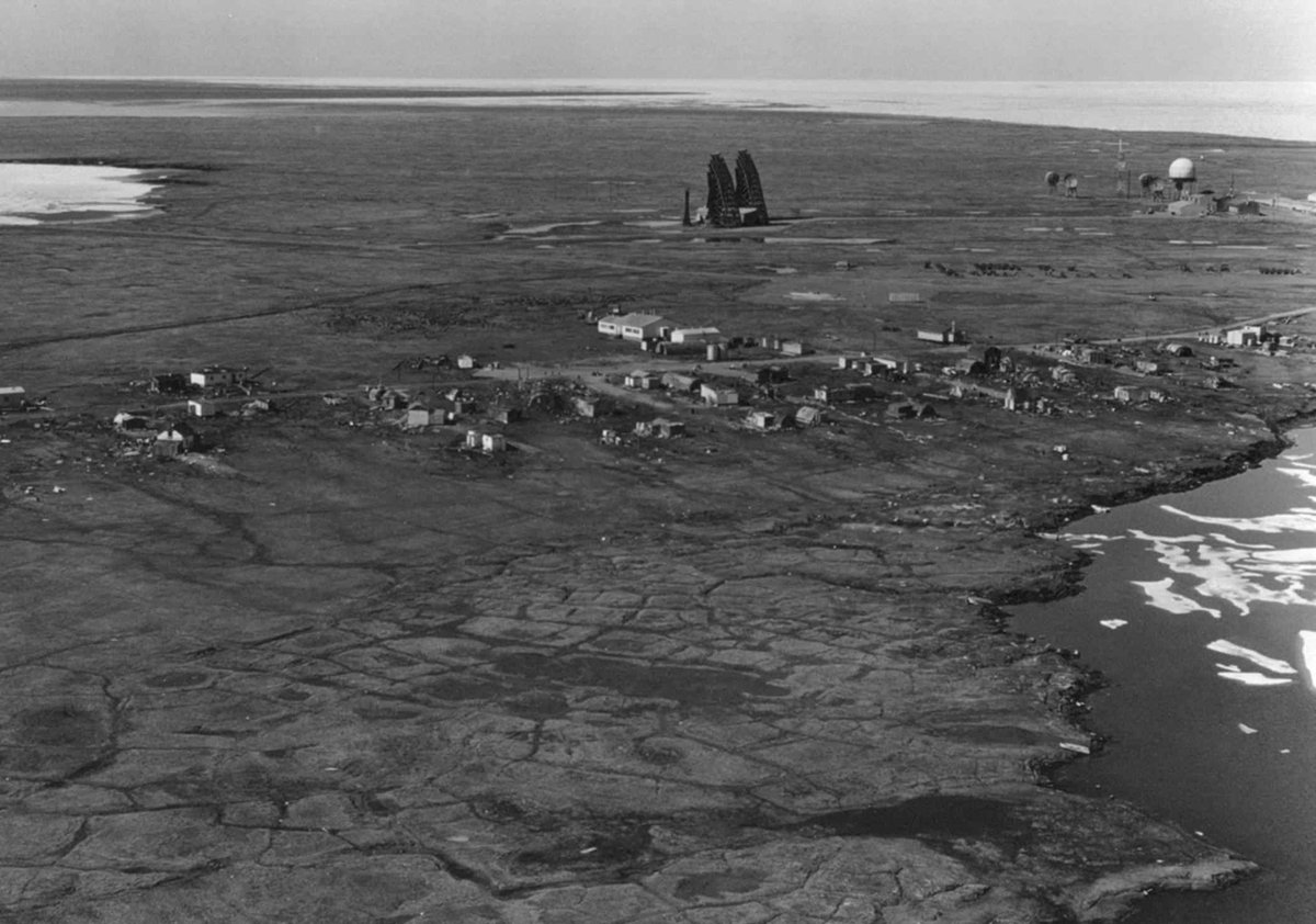
#Kaktovik, #Alaska on #BarterIsland, near a 1950s military radar station:
Some local #Inuit call the lagoon Akvakniakvuk (whaling place) Lagoon.
#Kaktovik, #Alaska on #BarterIsland, near a 1950s military radar station:
The #JagoRiver of Alaska empties into the Beaufort Sea's #JagoLagoon.
In 1919 Leffingwell modified the river's local name from Jags to Jago to honour Royal Navy Lieutenant Charles #Jago, a crew member on the HMS Enterprise that was sent in search of the lost Franklin Expedition.
In 1919 Leffingwell modified the river's local name from Jags to Jago to honour Royal Navy Lieutenant Charles #Jago, a crew member on the HMS Enterprise that was sent in search of the lost Franklin Expedition.

The #KongakutRiver of northeastern #Alaska terminates at #SikuLagoon on the Beaufort Sea.
The #Iñupiaq name #Kongakut translates as 'deer pond'. Siku means 'ice'.
The #Iñupiaq name #Kongakut translates as 'deer pond'. Siku means 'ice'.

#Alaska's #DemarcationBay lies near the border with Canada.
Demarcation Point, at the bay's entrance, was named in 1826 in reference to the boundary between British and Russian territory in North America. Its #Iñupiaq name, Pataktak, reportedly means 'place where ducks fly low.'
Demarcation Point, at the bay's entrance, was named in 1826 in reference to the boundary between British and Russian territory in North America. Its #Iñupiaq name, Pataktak, reportedly means 'place where ducks fly low.'

The #ClarenceRiver of #Yukon and #Alaska empties into #ClarenceLagoon on the #BeaufortSea.
Franklin named the river in 1826 after the Duke of #Clarence and St Andrews, who was crowned King William IV in 1830. #ClarenceHouse, a royal residence in London, was built for him.
Franklin named the river in 1826 after the Duke of #Clarence and St Andrews, who was crowned King William IV in 1830. #ClarenceHouse, a royal residence in London, was built for him.
The first Duke of Clarence was Lionel of Antwerp in 1362. Geoffrey #Chaucer was a page in his household.
The Clarence title comes from #ClareCastle in Clare, #Suffolk. First recorded as Clara, the town's name may be a Latin reference to the 'clear' water of Chilton Stream.
The Clarence title comes from #ClareCastle in Clare, #Suffolk. First recorded as Clara, the town's name may be a Latin reference to the 'clear' water of Chilton Stream.

The #MalcolmRiver terminates at the #BeaufortSea in #Yukon, #Canada. It was named in 1826 for Royal Navy Admiral Sir Pulteney Malcolm (1768–1838) from Dumfriesshire, Scotland.

'#Malcolm' (Máel Coluim or Maol Choluim in Scottish #Gaelic) means 'devotee of Saint Columba'.
Columba (or #Colmcille) was a 6th-century Irish abbot who converted Gaels and Picts to Christianity. He allegedly once banished a fierce 'water beast' to the depths of the River Ness.
Columba (or #Colmcille) was a 6th-century Irish abbot who converted Gaels and Picts to Christianity. He allegedly once banished a fierce 'water beast' to the depths of the River Ness.

The Firth River of #Alaska and Yukon was named in 1890 for John Firth, an agent of the Hudson's Bay Company at its Rampart House trading post in Old Crow, #Yukon.
The #FirthRiver in #Ivvavik National Park, #Canada:
[Image: en.wikipedia.org/wiki/File:Firt…]
The #FirthRiver in #Ivvavik National Park, #Canada:
[Image: en.wikipedia.org/wiki/File:Firt…]

US Navy officer Charles Stockton visited Herschel Island in 1889 and named several of its features. #ThetisCove was named for his ship, and #OrcaCove and #ThrasherBay for whaling ships that were in the area.
Stockton named #PaulineCove after his second wife.
Stockton named #PaulineCove after his second wife.

The #MackenzieRiver and its tributaries form Canada's longest river system, and North America's second largest drainage basin (after the Mississippi).
Its Indigenous names, 'Deh-Cho' in #Slavey and 'Kuukpak' in #Inuvialuktun, mean 'big river'.
[Image: en.wikipedia.org/wiki/File:Mack…]
Its Indigenous names, 'Deh-Cho' in #Slavey and 'Kuukpak' in #Inuvialuktun, mean 'big river'.
[Image: en.wikipedia.org/wiki/File:Mack…]

The Mackenzie River is named for Scottish explorer Alexander #Mackenzie, who followed its course downstream in 1789 hoping it offered a Northwest Passage to the Pacific. To his disappointment, he found that it instead flows to the Arctic Ocean.
[Image: en.wikipedia.org/wiki/File:Alex…]
[Image: en.wikipedia.org/wiki/File:Alex…]

Mackenzie is an anglicised form of the Scottish Gaelic family name MacCoinnich (son of Coinneach).
The personal name Coinneach (Kenneth in English) means 'comely'.
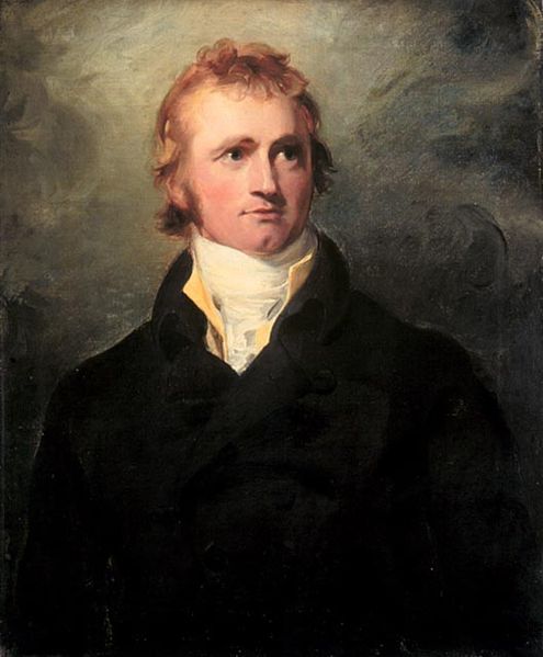
A portrait of explorer Alexander #Mackenzie painted by Sir Thomas Lawrence in 1800:
The personal name Coinneach (Kenneth in English) means 'comely'.
A portrait of explorer Alexander #Mackenzie painted by Sir Thomas Lawrence in 1800:
Mackenzie was originally written MacKenȝie and pronounced MacKenyee. In Middle English and Older Scots the letter ȝ (yogh) was pronounced like the y in yet.
Printing press operators substituted z for ȝ because their type cases didn't include ȝ, and ȝ resembles a cursive z.
Printing press operators substituted z for ȝ because their type cases didn't include ȝ, and ȝ resembles a cursive z.

The substitution of z for ȝ was common.
As northern Scotland gradually shifted from the Norn language to Scots, its northernmost islands gradually mutated from Hjaltland to Ȝetland to Zetland to Shetland.
Shetland's postcodes still begin with ZE.
As northern Scotland gradually shifted from the Norn language to Scots, its northernmost islands gradually mutated from Hjaltland to Ȝetland to Zetland to Shetland.
Shetland's postcodes still begin with ZE.
https://twitter.com/linglore/status/1147129402066722816
The #PeelRiver is a tributary of the Mackenzie, named after Sir Robert Peel, who twice served as Britain's Prime Minister.
The family name #Peel originated in Yorkshire. A peel was a fortified tower, ultimately derived from the Latin pālus (stake). Palisade has the same root.
The family name #Peel originated in Yorkshire. A peel was a fortified tower, ultimately derived from the Latin pālus (stake). Palisade has the same root.

The #OgilvieRiver is a tributary of the Peel River, originating in Canada's #OgilvieMountains. The area was surveyed by Canadian William #Ogilvie (1846–1912).
Clan #Ogilvy is a Highland clan from Angus, Scotland. The name derives from Brittonic 'Ocel-fa' meaning 'high plain'.
Clan #Ogilvy is a Highland clan from Angus, Scotland. The name derives from Brittonic 'Ocel-fa' meaning 'high plain'.

The Gwichʼin (or Kutchin) people live in northern Alaska and northwestern Canada.
The #BonnetPlumeRiver, a tributary of the Peel River, was named in honour of a Gwich'in chief. The river was called 'Tsaih Tl'ak Njik' (river of black ochre) in the Athabaskan Gwich'in language.
The #BonnetPlumeRiver, a tributary of the Peel River, was named in honour of a Gwich'in chief. The river was called 'Tsaih Tl'ak Njik' (river of black ochre) in the Athabaskan Gwich'in language.

The Gwichʼin name for Yukon's Snake River, a tributary of the Peel, is 'Gyuu Dazhoo Njik' (worm-hairy caterpillar).
Legend holds that a giant hairy worm (snake) left the sea and made the river by eating boulders as it slithered to the mountains.
[Image: flickr.com/photos/mikofox…]
Legend holds that a giant hairy worm (snake) left the sea and made the river by eating boulders as it slithered to the mountains.
[Image: flickr.com/photos/mikofox…]

The #ArcticRedRiver, a tributary of the Mackenzie in the Northwest Territories, is called 'Tsiigèhnjik' (river of iron) in Gwichʼin. Both the English name and the Gwichʼin name result from the red hue of the silt-stained water.

The #KeeleRiver is a tributary of the Mackenzie in the Northwest Territories, named for Irish explorer Joseph Keele, who surveyed its full length in 1907–08.
The river is called Begádeé (winding river) in the Northern Athabaskan languages.
[Image: en.wikipedia.org/wiki/File:Keel…]
The river is called Begádeé (winding river) in the Northern Athabaskan languages.
[Image: en.wikipedia.org/wiki/File:Keel…]

The #LiardRiver flows into the Mackenzie. Its name derives from a French word for the eastern cottonwood tree.
In Kaska, an Athabaskan language, it's called Nêtʼił Tué' (Hanging Down River), referring to goat snares that the #Kaska people hung along a narrow part of the river.
In Kaska, an Athabaskan language, it's called Nêtʼił Tué' (Hanging Down River), referring to goat snares that the #Kaska people hung along a narrow part of the river.

The South Nahanni River is a tributary of the Liard River.
#Nahanni is a Northern Athabaskan name meaning 'river of the land of the Nahʔa people', which may refer to the ancestors of the Navajo people of the southwestern United States. (Navajo is a Southern Athabaskan language.)
#Nahanni is a Northern Athabaskan name meaning 'river of the land of the Nahʔa people', which may refer to the ancestors of the Navajo people of the southwestern United States. (Navajo is a Southern Athabaskan language.)

The South Nahanni River features one of the world's largest waterfalls. Fenley Hunter of the Geological Survey of Canada (@GSC_CGC) named #VirginiaFalls in 1928 after his daughter, Virginia Hunter.
Its name in Slavey, a North Athabaskan language, is Nailicho (big water falling).
Its name in Slavey, a North Athabaskan language, is Nailicho (big water falling).

Canada's #PetitotRiver feeds the Liard River.
Linguist Émile #Petitot was one of the first Europeans to visit it in 1867–68. He created a dictionary of several Athabaskan languages.
The Slavey people call the river 'Mbehcholah' (the black).
[Image: en.wikipedia.org/wiki/File:Peti…]
Linguist Émile #Petitot was one of the first Europeans to visit it in 1867–68. He created a dictionary of several Athabaskan languages.
The Slavey people call the river 'Mbehcholah' (the black).
[Image: en.wikipedia.org/wiki/File:Peti…]
The Petitot River originates at #Bistcho Lake in the northwestern corner of Alberta. The lake's local Dene name (Mbecho) means 'big knife'.

Another tributary of the Liard River is British Columbia's Fort Nelson River, named for the town of #FortNelson, which in turn was named in honour of British Vice-Admiral Horatio Nelson.
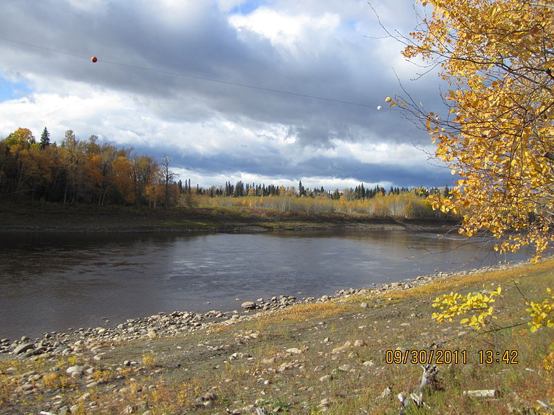
Freight boats on the #FortNelsonRiver around 1960:
Freight boats on the #FortNelsonRiver around 1960:

Horatio #Nelson's family came from Norfolk, England.
Their surname is an Anglicisation of the Norse Njálson (or Njálsson). Vikings adopted the name Njál (or Njáll) from the Old Irish male name Níall.
Njáls saga is a thirteenth-century Icelandic saga about blood feuds.
Their surname is an Anglicisation of the Norse Njálson (or Njálsson). Vikings adopted the name Njál (or Njáll) from the Old Irish male name Níall.
Njáls saga is a thirteenth-century Icelandic saga about blood feuds.

The Fort Nelson River forms at the confluence of the #SikanniChief and Fontas rivers.
The names of both tributaries refer to the Sekani people of British Columbia.
Originally Fantasque's River, the #Fontas is named for a Sekani chief.
#Sekani is a Northern Athabaskan language.
The names of both tributaries refer to the Sekani people of British Columbia.
Originally Fantasque's River, the #Fontas is named for a Sekani chief.
#Sekani is a Northern Athabaskan language.

The #CoalRiver is a tributary of the Liard River in Canada's Mackenzie river basin.
In 1831 it was named Charles River after John Charles of the Hudson's Bay Company. It was later renamed in reference to lignite deposits found along the river.
[Image: en.wikipedia.org/wiki/File:Coal…]
In 1831 it was named Charles River after John Charles of the Hudson's Bay Company. It was later renamed in reference to lignite deposits found along the river.
[Image: en.wikipedia.org/wiki/File:Coal…]

The #KechikaRiver ('Tah Chow Gàh' in Sekani) is a tributary of the Liard.
Some 19th-century maps label it the Black River after Scottish fur trader Samuel Black, who explored the river and named the tributary where he turned around '#Turnagain'.
[Image: en.wikipedia.org/wiki/File:Kech…]
Some 19th-century maps label it the Black River after Scottish fur trader Samuel Black, who explored the river and named the tributary where he turned around '#Turnagain'.
[Image: en.wikipedia.org/wiki/File:Kech…]

#DeaseLake is located at the head of the Dease River, a tributary of the Liard River in British Columbia, Canada.
Both were named in the 1830s by explorer John McLeod in honour of Arctic explorer Peter Warren #Dease.
Moose in the #DeaseRiver:
[Image: en.wikipedia.org/wiki/File:Deas…]
Both were named in the 1830s by explorer John McLeod in honour of Arctic explorer Peter Warren #Dease.
Moose in the #DeaseRiver:
[Image: en.wikipedia.org/wiki/File:Deas…]

The #RancheriaRiver is a tributary of the Liard River in Yukon, Canada.
A #ranchería was the residential area of a ranch in Spanish California, where most workers were Indigenous. '#Rancherie' is used throughout western North America to describe a part of an Indigenous reserve.
A #ranchería was the residential area of a ranch in Spanish California, where most workers were Indigenous. '#Rancherie' is used throughout western North America to describe a part of an Indigenous reserve.

The #TroutRiver is a tributary of the #MackenzieRiver in the Northwest Territories.
It begins at a lake formerly called 'Trout Lake'. In 2016 the lake and its main settlement were renamed 'Sambaa K’e', which means 'place of trout' in South Slavey, a Northern Athabaskan language.
It begins at a lake formerly called 'Trout Lake'. In 2016 the lake and its main settlement were renamed 'Sambaa K’e', which means 'place of trout' in South Slavey, a Northern Athabaskan language.

Alberta's #ChinchagaRiver flows into the #HayRiver, a tributary of the #MackenzieRiver.
'#Chinchaga' is of Northern Athabaskan origin. It means 'Big Timber River'. The river is lined with tall spruce trees and other conifers.
[Image: en.wikipedia.org/wiki/File:Chin…]
'#Chinchaga' is of Northern Athabaskan origin. It means 'Big Timber River'. The river is lined with tall spruce trees and other conifers.
[Image: en.wikipedia.org/wiki/File:Chin…]

Canada's Great Slave Lake, #SlaveRiver, Lesser Slave River, and Lesser Slave Lake are all named for the Deh Cho Dene people, known in English as 'Slavey'.
'#Slavey' is a translation of 'Awokanek', the Cree name for the Deh Cho #Dene, whom the Cree often raided and enslaved.
'#Slavey' is a translation of 'Awokanek', the Cree name for the Deh Cho #Dene, whom the Cree often raided and enslaved.

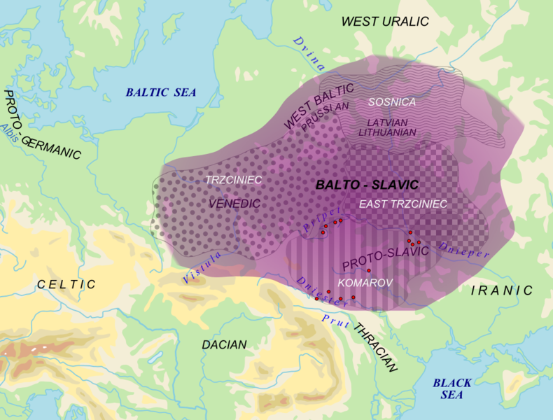
'Slave' derives from the Latin word for 'Slav'. In the Middle Ages Slavs were a common source of slaves.
Mediaeval Arabs called European slaves 'Saqaliba', from Middle Greek 'sklavenos' (Slav).
A Russian painting depicting (Norse) Rus' trading enslaved Slavs with Khazar Turks:
Mediaeval Arabs called European slaves 'Saqaliba', from Middle Greek 'sklavenos' (Slav).
A Russian painting depicting (Norse) Rus' trading enslaved Slavs with Khazar Turks:

Greek 'sklavenos' became Mediaeval Latin 'sclavus' (slave), which led to the Venetian expression 's-ciào vostro', meaning 'I am at your service' or 'I am your slave'. This is the source of the Italian greeting '#ciao', used to say 'hello' or 'goodbye'.

Some Indigenous people have recommended renaming Great Slave Lake to remove the mention of slavery.
Athabaskan names for the lake include 'Tucho' in Deh Cho Dene Zhatıé (Slavey), 'Tu Nedhé' in Dënësųłinë́, and 'Tıdeè' in Dogrib.
Athabaskan names for the lake include 'Tucho' in Deh Cho Dene Zhatıé (Slavey), 'Tu Nedhé' in Dënësųłinë́, and 'Tıdeè' in Dogrib.

• • •
Missing some Tweet in this thread? You can try to
force a refresh


.jpg)
.jpg)